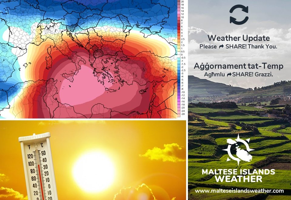
Maximum temperatures are currently at or slightly below the average for this time of year. Things will change next week, however. The Sahara Desert high pressure system will extend across the central Mediterranean. This will drag very hot air from over north Africa. From Monday 11/05 onward, temperatures will rise substantially. We may in fact experience a heatwave. By Malta’s definition, a heatwave is a spell of three or more consecutive days with daytime highs exceeding the mean maximum temperature for that particular time of year by 5°C or more. We may see this happen from Thursday 14/05 through to Saturday 16/05. Maximum temperatures on all three days will most likely exceed 30°C, with less conservative models predicting the possibility of a sweltering 35°C. The wind on these three days is anticipated to be very strong from the South. The UV Index will be at Level 10, which means a very high risk of harm from unprotected sun exposure. UV is highest in the early afternoon.
It-temperaturi massimi bħalissa jinsabu bejn wieħed u ieħor mal-medja għal dan iż-żmien tas-sena. Is-sitwazzjoni se tinbidel il-ġimgħa li ġejja, pero’. Sistema ta’ pressjoni baxxa fuq id-deżert tas-Sahara se testendi lejn iċ-ċentru tal-Mediterran. Din se ġġib magħha arja taħraq ħafna minn l-Afrika ta’ fuq. Minn nhar it-Tnejn 11/05 ‘il quddiem, it-temperaturi se jkunu qed jogħlew sew. F’Malta, ‘heatwave’ hija deskritta bħala perjodu b’minn ta’ l-anqas tlett ijiem konsekkuttivi fejn l-ogħla temperatura taqbeż il-medja għal dak iż-żmien tas-sena b’5°C jew aktar. Filfatt, nistgħu naraw dan iseħħ minn nhar il-Ħamis 14/05 sas-Sibt 16/05. L-ogħla temperatura matul dawn it-tlett ijiem probabli taqbeż it-30°C, u b’xi mudelli anqas konservattivi jindikaw il-possibilita li din tilħaq 35°C. Ir-riħ f’dawk il-jiem ser ikun qawwi ħafna minn Nofsinhar. L-Indiċi Ultravjola se tilħaq Livell 10. Dan ifisser riskju għoli ħafna ta’ ħsara minn esponiment mhux protett għax-xemx. Din tkun l-agħar kmieni wara nofsinhar.
0 comments
Write a comment