
Air Temperature
| Highest Maximum | 31.3°C | 3rd |
| Lowest Maximum | 19.4°C | 28th |
| Highest Minimum | 23.4°C | 3rd |
| Lowest Minimum | 13.5°C | 28th |
| Mean Maximum | 23.7°C |
| Mean Minimum | 18.5°C |
| Mean | 21.1°C |
Relative Humidity
| Highest Relative Humidity | 93% | Several Days |
| Lowest Relative Humidity | 44% | 6th |
| Mean Relative Humidity | 72.4% |
Atmospheric Pressure
| Highest Atmospheric Pressure | 1026.1hPa | 22nd |
| Lowest Atmospheric Pressure | 1005.8hPa | 3rd |
| Mean Atmospheric Pressure | 1017.4hPa |
Wind
| Highest Gust | 54.7km/h | 28th |
| Mean Wind Speed | 11.0km/h |
| Mean Gust Speed | 19.6km/h |
| Mean Wind + Gust Speed | 15.3km/h |
| Most Frequent Wind Direction | West Southwest |
Precipitation
| Total Rainfall During October 2020 | 32.5 mm |
| Total Rainfall Since Last 01/09 | 166.2 mm |
| Highest 24 Hour Total | 12.3 mm | 27th |
| Rain Days | 7 |
| Thunderstorm Days | 3 |
| Hail Days | 0 |
October 2020 Compared to the Climate Means
| Climate Mean | October 2020 | Anomaly | |
| Mean Maximum Temperature | 24.5°C | 23.7°C | -0.8°C |
| Mean Minimum Temperature | 18.2°C | 18.5°C | +0.3°C |
| Mean Temperature | 21.4°C | 21.1°C | -0.3°C |
| Mean Relative Humidity | 78% | 72.4% | -5.6% |
| Mean Atmospheric Pressure | 1017.6hPa | 1017.4hPa | -0.2hPa |
| Mean Wind Speed | 14.1 km/h | 15.3 km/h | +1.2km/h |
| Most Frequent Wind Direction | Northwest | West Southwest | -67.5° |
| Total Rainfall | 89.0 mm | 32.5 mm | -56.5 mm |
| Total Rainfall Since Last 01/09 | 138.9 mm | 166.2 mm | +27.3 mm |
| Total Rain Days | 9 | 7 | -2 |
| Total Thunderstorm Days | 5 | 3 | -2 |
| Total Hail Days | 1 | 0 | -1 |
A Marginally Cooler but Significantly Drier October 2020
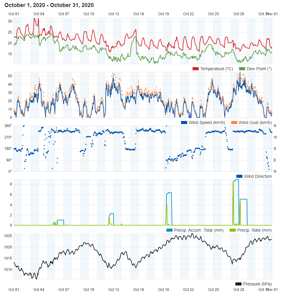
Overall, October 2020 turned out to be marginally cooler than the climate norm. At 23.7°C, daytime highs were almost a solid 0.8°C cooler than normal. Nights on the other hand, with an 18.5°C mean, were slightly warmer. Last month started off on a very warm note. It was the third October in the past decade to record a maximum temperature of over 30°C. This was on the 3rd, when the mercury shot up to 31.3°C. The transition to the cool season gained strong momentum during the second half of the month. Successive pockets of cooler air from over Europe meant a good number of days with cooler than average temperatures. A 13.5°C low, the coldest for October 2020, was registered on the 29th. This was accompanied by rain and strong winds brought about by a sharp cold front.
In a stark contrast to the previous month, October 2020 was very dry. The 32.5 mm of rain accumulated over the course of this month accounted for much less than half of October’s climate average. This was the result of anticyclonic conditions that prevailed over the central Mediterranean. These acted as a barrier, which weakened storms as soon as they reached the Maltese Islands. The 7 days of rain and 3 days of thunder observed last month were less than the norm for this time of year. October is renowned locally for being the stormiest month of the year. This year was different, as no severe rainfall events were experienced.
The average wind speed of 15.3 km/h almost confirmed with the climate mean. Winds from the West Southwest were more dominant. Two near gales (Force 7 winds) swept the Maltese Islands in October 2020, on the 12th / 13th and 27th / 28th.
Rainfall Totals around the Maltese Islands in October 2020
Għarb – 32.5 mm
Victoria – 26.3 mm
Xewkija – 26.4 mm
Nadur – 44.4 mm
Mellieħa – 33.0 mm
Buġibba – 36.3 mm
Mġarr – 23.1 mm
Għargħur – 51.5 mm
Attard – 61.7 mm
Rabat – 31.4 mm
Msida – 41.0 mm
Valletta – 20.0 mm
Luqa – 28.4 mm
Żabbar – 33.0 mm
Birżebbuġa – 34.0 mm
0 comments
Write a comment