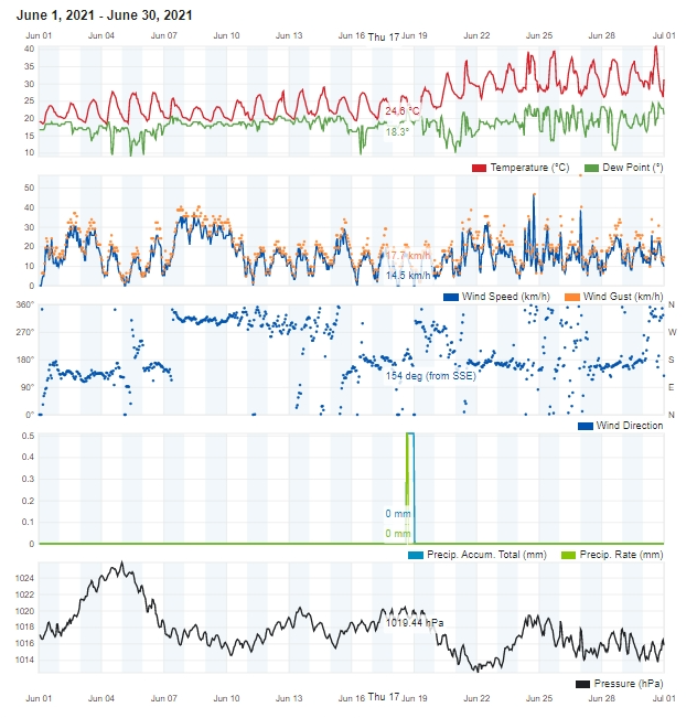
Air Temperature
| Highest Maximum | 40.8°C | 30th |
| Lowest Maximum | 23.3°C | 8th and 9th |
| Highest Minimum | 27.2°C | 23rd |
| Lowest Minimum | 17.8°C | 5th |
| Mean Maximum | 30.2°C |
| Mean Minimum | 21.4°C |
| Mean | 25.8°C |
Relative Humidity
| Highest Relative Humidity | 93% | Several Days |
| Lowest Relative Humidity | 18% | 25th and 28th |
| Mean Relative Humidity | 63.4% |
Atmospheric Pressure
| Highest Atmospheric Pressure | 1025.8hPa schweiz-libido.com | 4th |
| Lowest Atmospheric Pressure | 1012.2hPa | 22nd |
| Mean Atmospheric Pressure | 1017.5hPa |
Wind
| Highest Gust | 56.3km/h | 26th |
| Mean Wind Speed | 7.6km/h |
| Mean Gust Speed | 15.4km/h |
| Mean Wind + Gust Speed | 11.5km/h |
| Most Frequent Wind Direction | Northwest |
Precipitation
| Total Rainfall During June 2021 | 0.0 mm |
| Total Rainfall Since Last 01/09 | 414.7 mm |
| Highest 24 Hour Total | / | / |
| Rain Days | 0 |
| Thunderstorm Days | 0 |
| Hail Days | 0 |
June 2021 Compared to the Climate Means
| Climate Mean | June 2021 | Anomaly | |
| Mean Maximum Temperature | 28.2°C | 30.2°C | +2.0°C |
| Mean Minimum Temperature | 19.3°C | 21.4°C | +1.1°C |
| Mean Temperature | 23.8°C | 25.8°C | +2.0°C |
| Mean Relative Humidity | 71% | 63.4% | -7.6% |
| Mean Atmospheric Pressure | 1015.8hPa | 1017.5hPa | +1.7hPa |
| Mean Wind Speed | 15.2 km/h | 11.5 km/h | -3.7 km/h |
| Most Frequent Wind Direction | Northwest | Northwest | |
| Total Rainfall | 4.4 mm | 0.0 mm | -4.4 mm |
| Total Rainfall Since Last 01/09 | 548.0 mm | 414.7 mm | -133.3 mm |
| Total Rain Days | 1 day | 0 days | -1 day |
| Total Thunderstorm Days | 0 days | 0 days | / |
| Total Hail Days | 0 days | 0 days | / |
June 2021 brings Record-Breaking Temperatures
With a monthly average temperature of 25.8°C, June 2021 was a solid 2.0°C hotter than the climate norm. It was also the third hottest June on record in the Maltese Islands. Only those of 2019 and 2003 were hotter. The average maximum temperature was calculated at 30.2°C, surpassing the average for a normal June by 2.0°C. Nights were also rather warm. The average minimum temperature of 21.4°C exceeded the mean by 1.1°C. Using the national criteria for a heatwave, we can conclude that the Maltese Islands experienced one heatwaves during this month. This heat wave broke records. Lasting from 20th June through to 30th June (both days included), it ended up being the longest heatwave experienced locally. The previous record of 10 days was set in August 2017. The heat wave’s final day, 30th June, broke the record for the hottest June day ever. The temperature at our weather station in Għarb soared to 40.8°C on that day. An even higher value of 41.5°C was recorded at Malta International Airport. One other thing worth noting were the unseasonably cool first half of June. All days up till the 18th were cooler than average.
The difference in pressure between instability over the western Mediterranean and seasonal high pressure over the Sahara Desert set-up a stream of air from the Sahara Desert towards the western Mediterranean. This helped blow very hot air from the Sahara Desert across the central and southern Mediterranean. This state of affairs resulted in what we know as a heat dome. A heat dome is a weather phenomenon in which high-pressure atmospheric conditions trap air coming in from the Sahara Desert. The trapped air heats up at an alarming rate as it is compressed, like what happens under the lid on a saucepan. In normal conditions, winds are able to move a heat dome around, but because this particular heat dome stretched high into the atmosphere, it wasn’t easy to move about. This led to the persistent heatwave. The heat dome caused air pollution, desert sand and moisture to become stagnant, leading to a choked up atmosphere.
With the exception of an isolated shower on the 2nd, June 2021 was completely dry across the Maltese Islands. The last time a shower of over 1 mm affected our weather station in Għarb was way back in April.
Levels of relative humidity were also extremely low when compared to the norm. This was due to the relentless intense heat in the second half of the month. Several consecutive days with an average relative humidity in the region of 50% were registered. The driest days were the 25th and the 28th, with minimum readings of 18% on both.
Atmospheric pressure was slightly higher than the mean for this time of year, as stronger and more persistent anticyclonic behavior.
 r was noted.
Maximum wind gusts reached at least Force 5 on eighteen days last month. The highest wind gust was of 56.3 km/h, on the 26th.


0 comments
Write a comment