
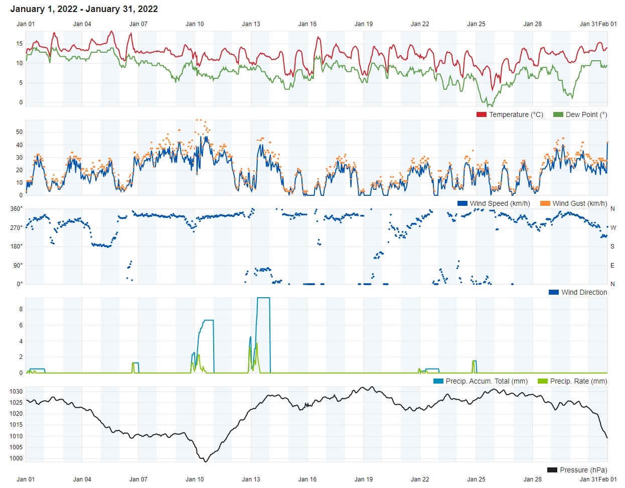
Air Temperature
| Highest Maximum | 18.2°C | 5th |
| Lowest Maximum | 9.3°C | 25th |
| Highest Minimum | 12.8°C | 3rd and 4th |
| Lowest Minimum | 2.9°C | 12th |
| Mean Maximum | 14.3°C |
| Mean Minimum | 8.9°C |
| Mean | 11.6°C |
Relative Humidity
| Lowest Relative Humidity | 44% | 23rd |
| Mean Relative Humidity | 77.8% |
Atmospheric Pressure
| Highest Atmospheric Pressure | 1032.1hPa | 19th |
| Lowest Atmospheric Pressure | 997.7hPa | 10th |
| Mean Atmospheric Pressure | 1021.3hPa |
Wind
| Highest Gust | 59.5km/h | 10th |
| Mean Wind Speed | 13.3km/h |
| Most Frequent Wind Direction | North Northwest |
Precipitation
| Total Rainfall During January 2022 | 35.1 mm |
| Total Rainfall Since Last 01/09 | 525.3 mm |
| Highest 24 Hour Total | 18.1 mm | 13th |
| Rain Days | 7 days |
| Thunderstorm Days | 1 day |
| Hail Days | 1 day |
Rainfall Events
| 06/01/2022 | 1.3 mm | Light Rain |
| 09/01/2022 | 2.5 mm | Showers |
| 10/01/2022 | 6.6 mm | Showers |
| 12/01/2022 | 4.6 mm | Showers |
| 13/01/2022 | 18.1 mm | Rainy |
| 21/01/2022 | 0.5 mm | Light Rain |
| 24/01/2022 | 1.5 mm | Rain and Hail Shower; Thunder |
January 2022 Compared to the Climate Means
| Climate Mean | January 2022 | Anomaly | |
| Mean Maximum Temperature | 15.6°C | 14.3°C | -1.3°C |
| Mean Minimum Temperature | 9.8°C | 8.9°C | -0.9°C |
| Mean Temperature | 12.7°C | 11.6°C | -1.1°C |
| Mean Relative Humidity | 79% | 77.8% | -2.2% |
| Mean Atmospheric Pressure | 1018.2hPa | 1021.3hPa | +3.1hPa |
| Mean Wind Speed | 18.9km/h | 13.3km/h | -5.6 km/h |
| Total Rainfall | 94.1 mm | 35.1 mm | -59.0 mm |
| Total Rainfall Since Last 01/09 | 436.2 mm | 525.3 mm | +89.1 mm |
| Total Rain Days | 14 days | 7 days | -7 days |
| Total Thunderstorm Days | 3 days | 1 day | -2 days |
| Total Hail Days | 1 day | 1 day | / |
Colder than Average in January 2022
The new year started off on a relatively warm note, with the month’s air temperature peaking at 18.2°C on the fifth day. Temperatures were consistently above average throughout the first week of January. From then on, a drop in temperatures was registered. The synoptic situation for much of January 2022 was marked by persistent high pressure across western Europe and successive zones of low pressure over the Balkans. This meteorological caused a series of cold snaps to traverse the central and eastern Mediterranean, with the more intense ones coming towards the end of the month. Last month’s mean minimum temperature was calculated at 8.9°C. The coldest night was on the 25th, when the minimum temperature dipped to a frosty 2.9°C. This was the coldest night in seven years. The 25th also marked the first time in five years that the maximum temperature failed to reach the 10°C level.
Overall, January 2022 was a drier than average month. Rainfall totals varied widely, however, with a number of localities in fact registering rainfall totals which exceeded the climate norm. Gozo and the western half of Malta were the drier regions. Our weather station registered a poor total of 35.1 mm over the course of the month. Localities across northern and central Malta were luckier in terms of rainfall, with a few localities almost reaching the 100 mm mark. It is worth noting how on the days that Gozo and western Malta remained relatively dry, but localities elsewhere received abundant rainfall, the wind was blowing from a predominantly North Northwest direction. This creates a form of rain shadow whose impact is felt far more profoundly across these areas. A kind of rain shadow forms over the Maltese Islands when the wind across the central Mediterranean blows from a northerly direction. Cold northerly air moving towards the Maltese Islands encounters Sicily (including Mount Etna which stands at 3,326 meters above sea-level) on its way. The advancing air is forced to rise and condense, producing rain-bearing clouds over Sicily. Precipitation occurs and the moisture carried by the cold northerly air is lost. As the cold northerly air advances further south, the stretch of sea between Sicily and the Maltese Islands is not wide enough for the air to recharge with moisture. As a result, the air is too dry to form any rain-bearing clouds locally. As a result, very little rain occurs over the Maltese Islands. That is why a North wind rarely brings any rain to our shores. As explained earlier, the rain shadow effect produced when the wind blows from the North Northwest is felt more over Gozo and western Malta.
Rainfall Totals around the Maltese Islands in January 2022 (and since last September 1st):
Għarb: 35.1 mm (525.3 mm)
Marsalforn: 43.2 mm (589.1 mm)
Victoria: 45.3 mm (548.8 mm)
Xewkija: 41.4 (509.8 mm)
Nadur: 48.9 mm (581.3 mm)
Mellieħa: 36.1 mm (512.5 mm)
Buġibba: 73.3 mm (581.2 mm)
Naxxar: 98.3 mm (590.8 mm)
Dingli: 56.6 mm (450.5 mm)
Mġarr: 74.4 mm (552.6 mm)
Mosta: 99.6 mm (499.5 mm)
Msida: 78.8 mm (557.4 mm)
Sliema: 83.4 mm (547.8 mm)
Valletta: 35.6 mm (341.8 mm)
Imqabba: 82.9 mm (529.8 mm)
Żabbar: 46.0 mm (557.6 mm)
Birżebbuġa: 47.7 mm (403.8 mm)
NATIONAL MEAN: 60.4 mm (522.3 mm)
0 comments
Write a comment