
Air Temperature
| Highest Maximum | 17.0°C | 15th |
| Lowest Maximum | 13.2°C | 28th |
| Highest Minimum | 13.0°C | 19th |
| Lowest Minimum | 5.3°C | 9th |
| Mean Maximum | 15.2°C |
| Mean Minimum | 9.4°C |
| Mean | 12.3°C |
Relative Humidity
| Lowest Relative Humidity | 43% | 8th |
| Mean Relative Humidity | 78.4% |
Atmospheric Pressure
| Highest Atmospheric Pressure | 1032.9hPa | 9th |
| Lowest Atmospheric Pressure | 1002.9hPa | 1st |
| Mean Atmospheric Pressure | 1020.7hPa |
Wind
| Highest Gust | 59.5km/h | 1st |
| Mean Wind Speed | 14.3km/h |
| Most Frequent Wind Direction | Northwest |
Precipitation
| Total Rainfall During February 2022 | 5.0 mm |
| Total Rainfall Since Last 01/09 | 530.3 mm |
| Highest 24 Hour Total | 3.3 mm | 1st |
| Rain Days | 4 days |
| Thunderstorm Days | 0 days |
| Hail Days | 1 day |
Rainfall Events
| 01/02/2022 | 3.3 mm | Rain and Hail Showers |
| 11/02/2022 | 0.3 mm | Dew |
| 13/02/2022 | 0.3 mm | Dew |
| 14/02/2022 | 0.3 mm več | Light Rain |
| 16/02/2022 | 0.5 mm | Light Rain |
| 23/02/2022 | 0.3 mm | Light Rain |
February 2022 Compared to the Climate Means
| Climate Mean | February 2022 | Anomaly | |
| Mean Maximum Temperature | 15.7°C | 15.2°C | -0.5°C |
| Mean Minimum Temperature | 9.5°C | 9.4°C | -0.1°C |
| Mean Temperature | 12.6°C | 12.3°C | -0.3°C |
| Mean Relative Humidity | 78% | 78.4% | +0.4% |
| Mean Atmospheric Pressure | 1016.6hPa | 1020.7hPa | +4.1hPa |
| Mean Wind Speed | 19.1km/h | 13.3km/h | -5.8 km/h |
| Total Rainfall | 61.6 mm | 5.0 mm | -56.6 mm |
| Total Rainfall Since Last 01/09 | 497.8 mm | 525.3 mm | +27.5 mm |
| Total Rain Days | 11 days | 4 days | -7 days |
| Total Thunderstorm Days | 3 days | 0 day | -3 days |
| Total Hail Days | 1 day | 1 day | / |
Significsntly Drier in February 2022
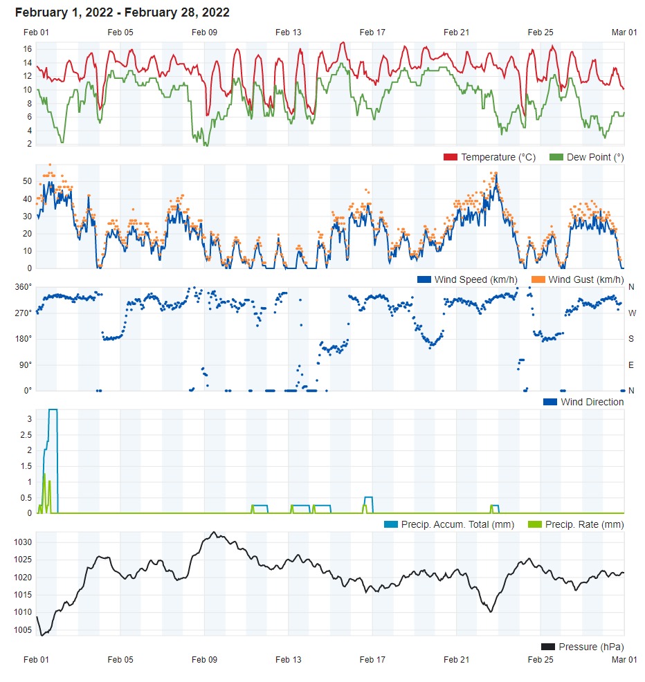
Rain over the course of February 2022 was very scarce. In fact, it was among the driest ever. Total daily rainfall exceeded 1.0 mm on only one day. This was on the 1st, when 3.3 mm were measured at our weather station. By the end of the month, 5.0 mm of rain had accumulated. This was from isolated light rain and/or dewfall on a number of days. February 2022 received less than 10% of the rain one would expect over the course of a typical February. No locality in the Maltese Islands accumulated more than 10 mm of rain last month. This serious lack of rainfall may be blamed on successive zones of high pressure that characterised the meterorological situation around the western Mediterranean. This prevented low pressure systems from reaching the central Mediterranean. The sheer stability that dominated much of last month was reflected in readings of atmospheric pressure and wind speed. Readings of atmospheric pressure were frequently above average for this time of year. No major gales were experienced last month. February is normally a very windy month locally.
Temperatures were overall cooler than average. This could be due to persistent zones of high pressure over central and eastern Europe. These patterns of atmospheric pressure direct cold air from northern Europe towards the Mediterranean. A number of nights were characterized by clear skies and a lack of wind. Clear skies at night allow heat to escape into the atmosphere, allowing air temperatures to dip. The coldest temperature last month was measured at 5.3°C, in the early hours of the 9th. A total of twelve nights registered minimum temperatures below the climate norm. Overall, with a difference of – 0.3°C from the mean, air temperatures were only marginally colder.
Rainfall Totals around the Maltese Islands in February 2022 (and since last September 1st):
Għarb: 5.0 mm (530.3 mm)
Victoria: 5.8 mm (548.8 mm)
Xewkija: 5.6 mm (515.4 mm)
Nadur: 2.3 mm (583.6mm)
Marsalforn: 5.1 mm (594.2 mm)
Mellieħa: 4.9 mm (517.4 mm)
Buġibba: 5.2 mm (586.4 mm)
Mġarr: 3.6 mm (556.2 mm)
Naxxar: 5.8 mm (596.6 mm)
Mosta: 3.9 mm (503.4 mm)
Dingli: 5.9 mm (456.4 mm)
Msida: 5.6 mm (563.0 mm)
Valletta: 6.4 mm (348.2 mm)
Imqabba: 3.3 mm (533.1 mm)
Żabbar: 7.8 mm (565.4 mm)
Birżebbuġa: 3.1 mm (406.9 mm)
Sliema: 3.5 mm (551.3 mm)
NATIONAL MEAN: 4.9 mm (527.2 mm)
0 comments
Write a comment