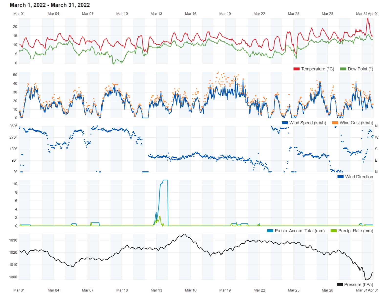
Air Temperature
| Highest Maximum | 24.6°C | 31st |
| Lowest Maximum | 11.9°C | 9th |
| Highest Minimum | 14.2°C | 31st |
| Lowest Minimum | 3.9°C | 25th |
| Mean Maximum | 15.5°C |
| Mean Minimum | 9.4°C |
| Mean | 12.4°C |
Relative Humidity
| Lowest Relative Humidity | 45% | 9th |
| Mean Relative Humidity | 75.7% |
Wind
| Highest Gust | 53.1km/h | 18th |
| Mean Wind Speed | 12.5km/h |
| Most Frequent Wind Direction | East Southeast |
Atmospheric Pressure
| Highest Atmospheric Pressure | 1035.0hPa | 15th |
| Lowest Atmospheric Pressure | 996.8hPa | 31st |
| Mean Atmospheric Pressure | 1020.9hPa |
Precipitation
| Total Rainfall During March 2022 | 21.2 mm |
| Total Rainfall Since Last 01/09 | 551.5 mm |
| Highest 24 Hour Total | 13.7 mm | 13th |
| Rain Days | 10 days |
| Thunderstorm Days | 2 days |
| Hail Days | 1 day |
Rainfall Events
| 01/03/2022 | 0.3 mm | Light Rain Shower. Hail and Thunder in Vicinity. |
| 05/03/2022 | 0.5 mm | Light Rain |
| 07/03/2022 | 0.8 mm | Light Rain |
| 12/03/2022 | 3.3 mm | P.M. Rain |
| 13/03/2022 | 13.7 mm | A.M. Rain. Thunder in Vicinity. |
| 19/03/2022 | 0.8 mm | Light Rain |
| 20/03/2022 | 0.5 mm | Light Rain |
| 21/03/2022 | 0.5 mm | Light Rain |
| 30/03/2022 | 0.5 mm | Light Rain |
| 31/03/2022 | 0.3 mm | Light Rain |
March 2022 Compared to the Climate Means
| Climate Mean | March 2022 | Anomaly | |
| Mean Maximum Temperature | 17.3°C | 15.5°C | -1.8°C |
| Mean Minimum Temperature | 10.7°C | 9.4°C | -1.3°C |
| Mean Temperature | 14.0°C | 12.4°C | -1.6°C |
| Mean Relative Humidity | 79% | 75.7% | -3.2% |
| Mean Atmospheric Pressure | 1016.1hPa | 1020.9hPa | +4.8hPa |
| Total Rainfall | 40.7 mm | 21.2 mm | -19.5 mm |
| Total Rainfall Since Last 01/09 | 538.5 mm | 551.5 mm | +13.0 mm |
| Total Rain Days | 9 days | 10 days | +1 day |
| Total Thunderstorm Days | 2 days | 2 days | / |
| Total Hail Days | 1 day | 1 day | / |
SIGNIFICANTLY COLDER in MARCH 2022
March 2022 continued the colder than average trend set in previous months. In fact, March turned out to be as cold as February. The mean temperature of 12.4°C was a staggering 1.6°C colder than the norm for this time of year. The mean maximum of 15.5°C and mean minimum of 9.4°C were 1.8°C and 1.3°C colder than the climate mean respectively. March 2022 was the coldest March in decades. The mercury dipped to a chilly 3.9°C in the early hours of the 25th, making that night one of the coldest March nights on record. Less than a week later, at around noon on the 31st, the Maltese Islands experienced one of the warmest March days in recent years. The temperature spiked to 24.6°C at our weather station on the final day of the month. Values were even higher in areas further inland. Minimum temperatures dropped to below the 10°C mark on a total of eighteen nights. The only average or slightly warmer than average days came in the month’s final week, indicating the much anticipated start of spring’s gradual rise in temperatures.
Although rainfall over the course of March 2022 was lower than the average, there was still a marked improvement over the previous month. The 21.2 mm accumulated by the end of the month were around half the total rainfall expected in a typical March. The bulk fell in a rainy episode halfway through the month (12th and 13th). The rest were produced by sporadic rain showers. Much of these showers deposited fine desert sand brought over by a predominant Sirocco wind.
Half of last month featured winds blowing from the Sirocco quarter. In fact, most days during March 2022 featured a hazy sky. This was due to the abundant fine desert sand blown across the Mediterranean by the southerly winds. Last month’s highlight was a gale-force wind from the East Southeast on the 18th and 19th.
The meteorological situation across Europe was fairly uniform last month. The meteorological situation over eastern Europe was characterized by an unusually strong and extensive area of high pressure. This anticyclone had been stationary over the region for a long while. Such a meteorological setting helped maintain a persistent stream of cold air from Siberia all the way to the central Mediterranean, keeping temperatures locally below the climatic norm. Further to this, a fairly stable atmosphere across our area deviated most rain-bearing systems to the north, maintaining the drier weather. The colder air further aggravated the situation. Things took a turn to a more seasonal meteorological setting by the final week of the month. Systems of low pressure of north African origin started developing over Tunisia. These traversed the central Mediterranean bringing warmer temperatures, elevated levels of humidity, dustier air and southerly winds.

Rainfall Totals around the Maltese Islands in March 2022 (and since last September 1st):
Għarb: 21.2 mm (551.5 mm)
Victoria: 23.7 mm (572.5 mm)
Xewkija: 18.7 mm (534.1 mm)
Nadur: 23.9 mm (607.5mm)
Marsalforn: 15.8 mm (610.0 mm)
Mellieħa: 19.0 mm (536.4 mm)
Buġibba: 22.0 mm (608.4 mm)
Mġarr: 21.8 mm (578.0 mm)
Naxxar: 22.7 mm (619.3 mm)
Mosta: 20.0 mm (523.4 mm)
Dingli: 23.5 mm (479.9 mm)
Msida: 20.4 mm (583.4 mm)
Valletta: 14.8 mm (363.0 mm)
Imqabba: 30.2 mm (563.3 mm)
Żabbar: 17.1 mm (582.5 mm)
Birżebbuġa: 14.3 mm (421.2 mm)
Sliema: 15.7 mm (567.0 mm)
NATIONAL MEAN: 20.3 mm (547.5 mm)


0 comments
Write a comment