Learn About The Weather

Learn About The Weather

Why do forecasts vary from one website to another?

People have been trying to predict the weather for thousands of years. You’d assume that by now we’d have it sorted out. Yet, you open three different weather sites and you find three slightly different forecasts. Why? How can forecasts for a small area like the Maltese Islands vary from one site to the other? These are two very valid questions. Meteorology is an art as much as it is a science.

Weather forecasts are derived from weather maps. There are various different weather maps available. All of these weather maps cover more or less the same parameters for exactly the same place over the same time. The production of these weather maps is the scientific part of weather forecasting. Now comes it’s artistic aspect. Each of these maps differ slightly from one another. These must be interpreted by humans. Humans must choose the map they deem to be the most realistic and reliable. The forecast is produced based on the chosen map. Thus, the final forecast depends on the decisions taken by the forecaster. Different weather sites employ different forecasters. Different forecasters have different knowledge levels. Different forecasters could interpret the same map differently. Different forecasters may prefer one map over another. Different forecasters make different errors of judgement along the way. And so on. Here are some common ways how human error may cause forecasts to vary from one site to another:

  • Misreading the forecast data. This occurs from not spending enough time at examining various weather data or looking over the weather data too quickly.
  • Not having enough analysis skills to interpret the weather data correctly.
  • Biasing the data toward “weather wishes”. Common weather wishes include a severe weather event or winter storm event. Wanting a particular type of weather and that weather occurring are two independent issues.
  • Relying too heavily on someone else’s forecast instead of drawing your conclusions directly from the weather data.
  • Lack of personal experience. It helps to know the local effects within a forecast region. Experience by learning from forecast mistakes produced by local effects will make you a better forecaster for that region over time. Also, those experienced with knowing model biases will have an edge over those who do not. The memory of weather patterns in the past is often beneficial to know when a similar pattern sets up.
  • Drawing illogical or meteorologically unsound conclusions from the weather data.
  • Not recognizing what the major forecast challenge for the day will be. For example, coming up with a finely turned temperature forecast is not as important as determining if severe storms will occur.
  • Not recognizing bad or irrelevant weather data.
  • Reading the valid time for weather data incorrectly.
  • Making the forecast too specific that it does not properly account for uncertainty or making the forecast too general that is does not have enough meaningful information.
  • Not communicating the forecast clearly to the target audience. A forecast to others is only as good as who hears it and who understands it.
  • A forecast that goes out of limb for the sole basis of being different from others.
Learn About The Weather

Record-breaking mean sea-level pressure

The chief suspect behind these unusually dry past two months is an atmospheric pressure pattern called the Arctic Oscillation, which circles the high Northern Hemisphere. Its lower edge is known as the North Atlantic Oscillation (NAO). Together, they influence the path and strength of the jet stream. The jet stream is a very strong air current that flows west to east across the northern hemisphere, altering temperature and precipitation as portions of it dip southward or crest northward. The NAO can either be negative or positive. At the beginning of December, it turned positive. A positive NAO oscillation causes a stronger than normal Azores High to prevail out over the Atlantic. On the other hand, the Icelandic Low is abnormally weak. As a result of this, the jet stream is keeping to the north. The Azores High is so strong that its effects are being as far north as Scandinavia. This setting favours the formation of persistent high pressure over large swathes of Europe. This weekend, an extremely strong high pressure system has formed over eastern parts of the north Atlantic. This expanded over the British Isles, and should continue to creep across western and central Europe this week. A large part of Europe will experience a pressure reading of between 1030hPa and 1045hPa. Some regions could see up to 1050hPa as well. These readings are record-breaking for many regions.

Mean sea-level pressure over the Maltese Islands will be of 1036hPa at its highest ed-hrvatski.com. This would come extremely close to breaking the record. The highest pressure ever measured by our weather station in Għarb was of 1035.8hPa on 9th January 2015.

This extremely high atmospheric pressure may cause the most sensitive of us to experience an odd sensation of ear popping, especially on Tuesday 21/01. Ear popping is something we normally associate with being on an aeroplane. A change in atmospheric pressure can be felt in your ear. The inner ear is filled with fluid, and that fluid is sensitive to changes in atmospheric pressure. The pressure inside your ears takes time to acclimatise. When atmospheric pressure varies rapidly, you may feel a sensation of fullness or popping in the ears, as the pressure inside your ears acclimatises.

Learn About The Weather

Smog

Cities across southern Europe are experiencing dangerously high levels of smog caused by a prolonged period of dry sunny weather and light winds. Temporary bans on diesel vehicles have been ordered in Italian cities in an effort to reduce pollution. Meanwhile, in Bosnia-Herzegovina, protesters have taken to the streets in gas masks demanding action from the government. Environmentalists have described the situation as an emergency.

Smog is a type of intense air pollution. The term ‘smog’ was coined in the early 20th century. It is a combination of the words ‘smoke’ and ‘fog’ to refer to smoky fog. Smog is composed of nitrogen oxides, sulphur oxides, ozone and smoke. Man-made smog is derived from the emissions created by fossil fuel combustion. In nature, these are often the result of fires. There are two main kinds of smog. These are summer or winter smog. Summer smog forms with the photo-chemical formation of ozone. In the summer season, when the temperatures are warmer and sunlight is plentiful, reactions occur between pollutants in the atmosphere. These reactions produce ozone. When it occurs at ground-level, ozone is dangerous. In the winter season, when the temperatures are cold, fossil fuel usage spikes. A rise in emission is the result https://polska-ed.com/kupic-generic-cialis/. Both smog types require anticyclonic conditions to form. Anticyclonic conditions are associated with light winds. Light winds prevent the dispersion of pollution, allowing it to build-up.

Learn About The Weather

Rain hits Australia’s east coast

Intense thunderstorms have brought heavy rain, hail and strong winds to some regions of Australia. Several of the regions hit have been ravaged by some of the worst bush fires in decades. People and wildlife alike have celebrated the rain. It has helped disperse in major cities like Melbourne and Sydney. A number of fierce bush fires have now been extinguished, or at least weakened. Meteorologists warned, however, that intense thunderstorms may lead to flash flooding. Lightning also brought the risk of new fires being ignited, especially when it was accompanied by no rain. The region of eastern Australia will be characterised by unsettled weather in the next few days. The rainfall in some areas might be useful and in other spots it might only be a millimetre or two. There were still 85 fires burning across the state of New South Wales on Thursday, with 30 of them yet to be contained, while 19 fires were alight in Victoria, according to fire authorities.

Learn About The Weather

2019-2020 Australian bush fire season

Bush fires are by no means alien to Australia. They are a yearly occurrence which has been taking place for centuries if not millennia. In southeast Australia, bush fires are most common and most severe in the summer and autumn months. Southeast Australia is fire-prone, and warm and dry conditions intensify the probability of fires. This year’s bush fires are regarded by some as one of the worst bush fire seasons in memory. When compared to the previous seasons, this year’s bush fires have burned an estimated 6.3 million hectares of bush (about 185 times the size of the Maltese Islands), destroyed over 2,500 buildings and killed 25 people as of 5 January 2020. So far, it is estimated that close to half a billion animals were impacted by the ongoing fires.

Why is this year’s bush fire season the worst in memory?

In the second half of 2019, Australia experienced a record-breaking heatwave. The record of the average temperature across the country was broken twice. The first was of 40.9°C, followed by 41.9°C. The prior record was set in 2013. This meteorological situation has led to Australia experiencing one of its worst droughts. There was an occasion back in 2019, when the whole of Australia experienced a day when not a single drop of rain was measured anywhere. It was the first time since the 1800s that this happened. This meteorological situation has partly been brought about by a positive Indian Ocean Dipole. The Indian Ocean Dipole is an irregular variation in the sea-surface temperatures across the western Indian Ocean. The western Indian Ocean becomes alternately warmer (positive phase) and colder (negative phase) than the eastern part of the ocean. A positive phase sees above-average sea-surface temperatures and greater precipitation in the western Indian Ocean region, with a corresponding cooling of waters for the eastern Indian Ocean region. This tends to cause droughts across the adjacent land areas of Indonesia and Australia. The cooler waters across the eastern Indian Ocean region weaken winds over there, reducing significantly the amount of moisture picked up and transported across Australia https://polska-ed.com/kupic-generic-cialis/. The consequence is well below average rainfall across south-east Australia.

Learn About The Weather

Rain shadow

A rain shadow is a dry area on the leeward side of a stretch of land (normally a highland or mountainous area). This stretch of land dries up the air within a rain-producing weather system, casting an area of dryness on the leeward side. Wind and moist air is drawn by prevailing winds across this stretch of land. It condenses and precipitates as it does so. The air, without much moisture left (and no body of water to recharge itself), advances on creating an area of dryness called the rain shadow.

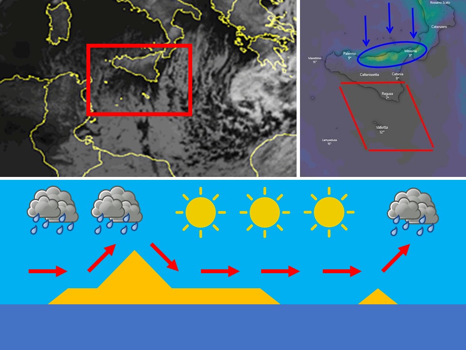
A kind of rain shadow forms over the Maltese Islands when the wind across the central Mediterranean blows from a northerly direction. Cold northerly air (blue arrows) moving towards the Maltese Islands encounters Sicily (including Mount Etna which stands at 3,326 meters above sea-level) on its way. The air is forced to rise and condense. Condensation produces rain-bearing clouds over Sicily’s northern coast (area encircled in blue). Precipitation occurs and the moisture carried by the cold northerly air is lost. As the cold northerly air advances further south, the stretch of sea between Sicily and the Maltese Islands is not wide enough for the air to recharge with moisture. As a result, the air is too dry to form any rain-bearing clouds locally. As a result, very little rain occurs over the Maltese Islands. That is why a North wind rarely brings any rain to our shores. This rain shadow is the the grey area indicated within the red lines. The satellite image on the left indicates today’s rain shadow formation. The bottom diagram is a diagram to help you understand the process more.

Learn About The Weather

Winter solstice

The astronomical start of a season is based on the position of the Earth in relation to the Sun. The start of each season is marked by either a solstice (winter and summer) or an equinox (spring and autumn). A solstice takes place when the Sun reaches the most southerly or northerly point in the sky, while an equinox marks the point when the Sun passes over Earth’s equator.

The winter solstice occurs when one of the Earth’s poles, the north pole in the case of the Northern Hemisphere, has its maximum tilt away from the Sun. It happens twice yearly, once in each hemisphere. The winter solstice is the day with the shortest period of daylight and longest night of the year. The Sun is at its lowest daily maximum elevation in the sky. At the pole, there is continuous darkness around the winter solstice. The winter solstice marks the beginning of winter. Because of leap years, the dates of the equinoxes and solstices can shift by a day or two over time, causing the start dates of the seasons to shift too. For instance, this year, winter started on Sunday, December 22nd and not on Saturday, December 21st!

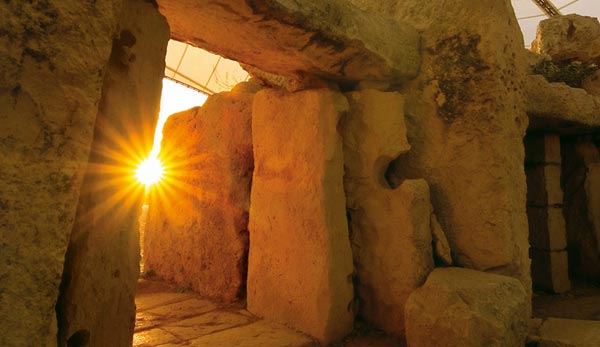
Since prehistory, the winter solstice has been seen as a significant time of year in many cultures, and has been marked by festivals and rituals. On the first day of each season, the rises in a particular alignment to the prehistoric temples of Ħaġar Qim and Mnajdra. They are so systematic that it is very probably that these orientations were intentional. In prehistory, the observation of the motion of celestial bodies was related to the changing season and times of planting and harvesting of crops.

From tomorrow onward, the length of the day will again start increasing again! For those of you who love summer, see this day as the start of the road to summer.

Learn About The Weather

Airborne Fine Desert Sand

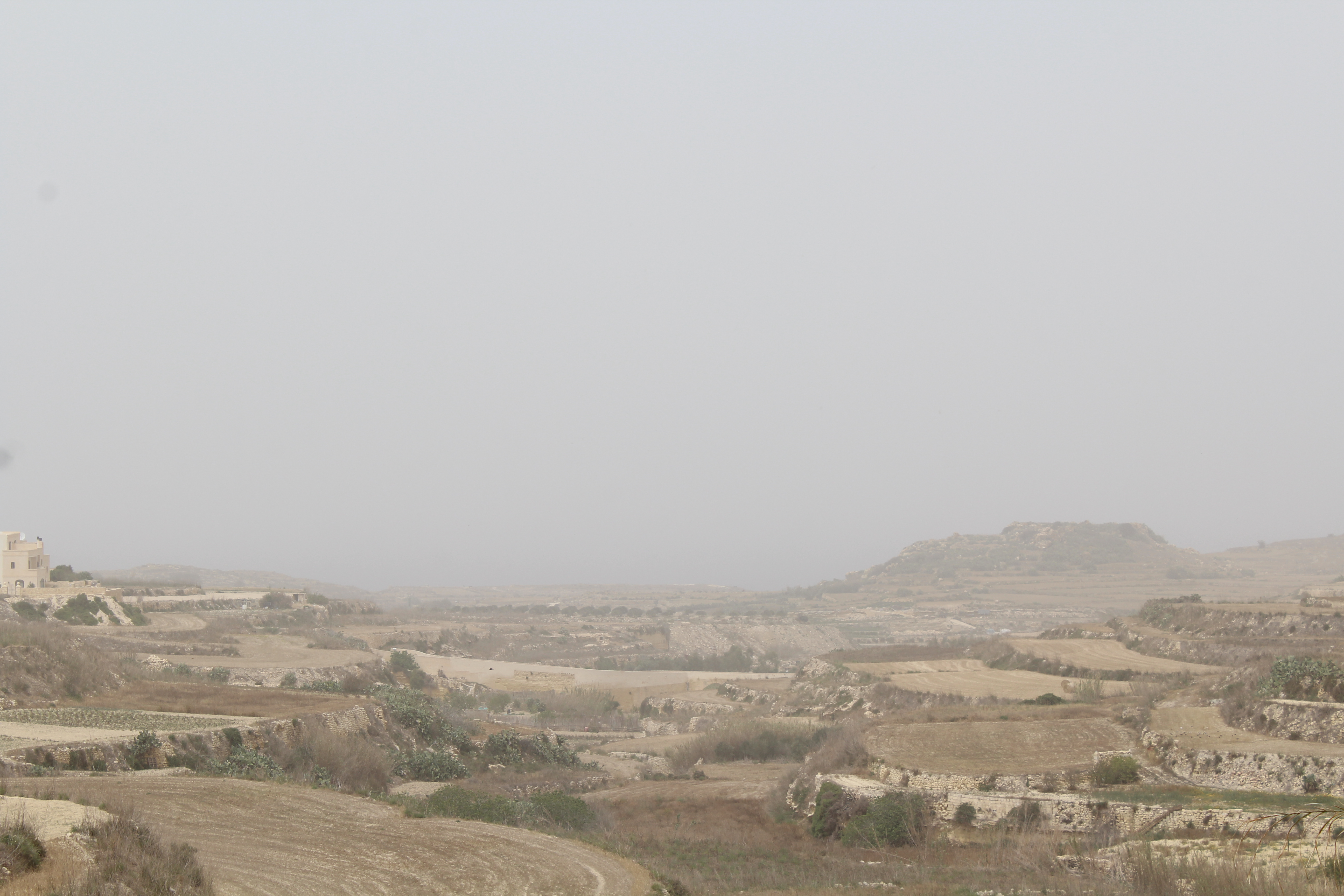
The atmosphere around the Maltese Islands is choked with fine desert sand from the Sahara Desert today. Ever wondered how it ends up here?


Transport of Fine Desert Sand

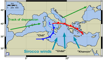
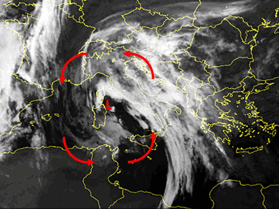
Airborne fine desert sand in the atmosphere around the Maltese Islands typically occurs on a day characterised by a Scirocco wind. The term Scirocco is an all-inclusive name given to hot and subsequently humid southeast to southwest winds originating over northern Africa and flowing into the southern Mediterranean basin. Sciroccos occur in advance of a low pressure system moving eastward across the southern Mediterranean Sea or northern Africa. Air from high pressure over the Sahara Desert rushes in to fill this low pressure system https://polska-ed.com/kupic-generic-cialis/. The rushing air manifests itself as a Scirocco.

Strong Sciroccos over the Sahara Desert whip up large amounts of fine desert sand, causing sandstorms across north Africa. When the center of an intense low pressure system happens to be traversing the region affected by sandstorms, it acts as a funnel which sucks the airborne fine desert sand and transports it far north, towards the southern Mediterranean Sea. Our islands happen to be located in an area which frequently experiences this kind of meteorological scenario. It is particularly common in spring, but can occur at any point during the year.


Deposition of Fine Desert Sand

As the airborne fine desert sand is transported across our region, the atmosphere attains a reddish hue. At ground level, it manifests itself as a reddish mist. Airborne fine desert sand is deposited in dry form this way.

It is also deposited in copious amounts with rain. Water vapour in the atmosphere requires a non-gaseous surface to make the transition from a vapour to a liquid. This transitional process is called condensation. This non-gaseous surface presents itself as tiny solid or liquid particles called Cloud Condensation Nuclei. When abundant, the airborne fine desert sand acts as a particle onto which water vapour can condense. As a result, when the rain falls, it drags down with it the sand particle. Once the rain dries up it leaves behind the sand particle.

Learn About The Weather

Can earthquakes and tsunamis occur in the Maltese Islands?

With the recent earthquakes across the Balkans and the eastern Mediterranean, you may be asking yourselves about whether the Maltese Islands are at risk of an earthquake or not.

The risk of earthquakes in the Maltese Islands is considered to be low. However, several earthquakes (some of which were damaging) were recorded in the past. The archipelago is in a potentially significant seismic zone.

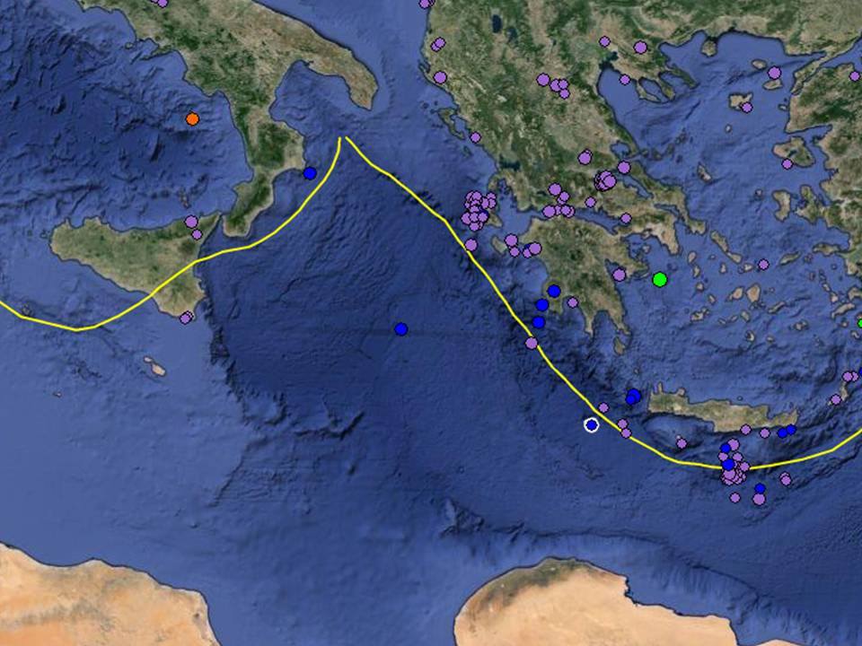
Look at the seismological map below. The yellow line indicates the boundary that separates the Eurasian plate from the African plate. Along this line the chance for earthquakes is considered high. However, notice how the areas near Greece are much more active than those near us. We are sitting on the same fault, so why the difference? Whereas a volcano exists on our side (Mount Etna) there are none near Greece. Etna erupts frequently. These  eruptions release pressure within the crust; therefore reducing the strength and frequency of earthquakes near to us. To the east, there are no volcanoes and so it experiences a lot of earthquakes, some of which are strong. This was seen in recent days. A deadly earthquake struck Albania. Several other earthquakes rattled the Balkans and the eastern Mediterranean.

In the past there have been several tsunamis in the Mediterranean with the most recent being in 2003 and 1999. We have had them before and will therefore most likely have them again in the future. Having said that, a tsunami in the Mediterranean would be much weaker than the ones that occur in the ocean. A tsunami in the Mediterranean would most likely occur after some strong earthquake in the eastern basin or due to a submarine land slide associated with Mount Etna. However, given the varying depths of the Mediterranean and the small size of the basin it would not be as powerful as the ones that occur in the ocean. Therefore, the wave would likely hit nearby coasts hard but then fade away as it spreads around the basin, regardless of the magnitude of the earthquake. You might think that the Maltese Islands, being located right at the centre of the Mediterranean Sea makes them highly vulnerable. This is simply not true. The waves reaching us would be very similar to those we get in the strongest of storms. This is because we are sheltered from tsunamis from the west and east by repeatedly varying ocean depth on both sides. On the other hand, we are sheltered from a tsunami caused by Etna by the south east coast of Sicily. The risk of a serious tsunami in the Maltese Islands, is therefore very low. It may only occur if a strong earthquake strikes close-by. This is not possible as long as the volcanic activity of our region remains as it is, since Mount Etna releases the pressure within the crust through the frequent eruptions.

The strongest earthquake ever recorded in Malta was that of 11th January 1693, when a 7.4 MAG earthquake struck east of Sicily.


Learn About The Weather

The weather as a headache, migraine and SAD trigger

A number of weather conditions (mainly humidity, temperatures, dusty atmosphere and lack of sun) mess our brain chemistry. For example sunshine gives us serotonin (a chemical which makes us feel happy) and so when there is little sunshine (especially when the sun is covered by a uniform grey cloud or a red hue due to airborne fine desert sand) the levels of serotonin in our brain dip, thus making us feel a bit down. These affects are obviously felt more by people who already are experiencing depression or other related conditions. The fluctuation in brain chemical can trigger headaches and sometimes also migraines.

Very often, the Sun has the reputation for only leaving a negative impact on our health, when in fact, its benefits are many. Like many things in life, sunshine should be enjoyed in moderation.

Some positive impacts

  • It enhances your mood. Being in the Sun can help people feel better and more energetic. Sunlight increases the levels of serotonin in the brain. Serotonin is associated with improved mood. Not surprisingly, serotonin levels are highest in the summer months.
  • It helps relieve stress. Life in itself induces stress. Be it through work, family or health related issues. Stress can be relieved in various ways. One of them is through exposure to sunlight.
  • It helps treat Seasonal Affective Disorder. In some people, the lack of sunlight in winter can trigger depression. Symptoms include bad moods, difficulty making and keeping friends, overeating, tiredness and sleeping far too much.
  • It improves sleep quality. Exposure to sunlight impacts how much melotonin your body produces. Melotonin is the chemical that tells your brain when it is time to sleep. With a lack of sunlight, your body produces far more melotonin than is needed. Hence, you feel tired and ready to sleep more often and earlier.
  • It provides you with Vitamin D. It is often referred to as the sun vitamin. Vitamin D is involved in maintaining a healthy body. One way you can get this vitamin is exposure to the ultraviolet light from the sun.

You don’t need much time in the sun to take advantage of these benefits. Only 15 to 30 minutes of sun exposure is all you need. Why not spend your break-time at work in the Sun?