Learn About The Weather

Learn About The Weather

Pressure Systems

ANTICYCLONES

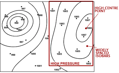
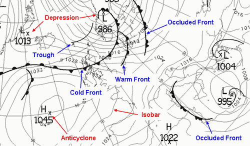
A high pressure system, also known as an anticyclone occurs when the weather is dominated by stable conditions. Under anticyclonic conditions, the air is descending, forming an area of high pressure at the surface. Because of these stable conditions, cloud formation is inhibited, so the weather is usually settled with only small amounts of cloud cover. Anticyclones can be identified on weather charts as an often large area of widely spaced isobars, where pressure is higher than surrounding areas.

There is a difference between anticyclones in winter and anticyclones in summer. In winter, the clear conditions and light winds associated with anticyclones can lead to frost and fog. The clear skies allow heat to be lost from the surface of the earth through radiation, allowing temperatures to fall steadily overnight, leading to air or ground frosts. Light winds along with falling temperatures encourage fog to form. In summer, the clear conditions associated with anticyclones can bring long sunny days and warm temperatures. The weather is normally dry, although occasionally, very hot temperatures can trigger thunderstorms.


LOW PRESSURE SYSTEMS

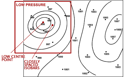
A low pressure system, also known as a depression occurs when the weather is dominated by unstable conditions. Under a depression air is rising, forming an area of low pressure at the surface. This rising air cools and condenses and helps encourage cloud formation, so the weather is often cloudy and wet. Depressions can be identified on weather charts as an area of closely spaced isobars, often in a roughly circular shape, where pressure is lower than surrounding areas. They are often accompanied by fronts.


FRONTS

Large air masses with similar temperatures and humidity form in different parts of the world. They are classified by temperature as arctic, polar, tropical or equatorial and by their humidity level as continental (dry) or maritime (moist). Air masses of different properties do not mix together, forming a low pressure system. The sharp boundary between air masses is called a front. There are three types of fronts: cold fronts, warm fronts and occluded fronts.

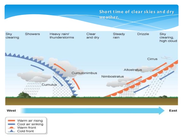
A warm front indicates that warm air is advancing and rising up over colder air. This is because the warm air is less dense than the cold air. Therefore, warm fronts occur where warmer air is replacing colder air at the surface. As the warm front approaches a gradual deterioration in weather conditions occurs. Clouds gradually lower from higher cirrus, through altostratus, to stratus and nimbostratus at the front. There is often a prolonged spell of rainfall which is often heavy. Behind the warm front the rain becomes lighter and the sky remains cloudy.

A cold front indicates that cold air is advancing and pushing underneath warmer air at the surface. This occurs because the cold air is denser than the warm air. Therefore, cold fronts occur where cooler air is replacing warmer air at the surface. The impact  associated with a cold front is much shorter lived than that with a warm front. As there is often a lot of cloud in the warmer air ahead of the cold front, there is often little indication of the approaching cold front. As the front passes temperatures fall and there is often a short spell of very heavy rain, sometimes with embedded thunderstorms and cumulonimbus clouds. Behind the front the weather is much brighter with broken clouds but occasional showers. Winds veer with the passage of the cold front and are often strong and gusty, especially near showers. Pressure rises throughout the approach and passage of the cold front.

In a mature depression the warm front normally precedes the cold front. Cold fronts generally travel much quicker than warm fronts, and eventually it will catch up with the warm front. Where the two fronts meet, warm air is lifted from the surface and an occlusion is formed. An occlusion can be thought of as having similar characteristics to both warm and cold fronts. The weather ahead of an occlusion is similar to that ahead of a warm front, whilst the weather behind is similar to that behind a cold front.


LIFE CYCLE OF LOW PRESSURE SYSTEMS

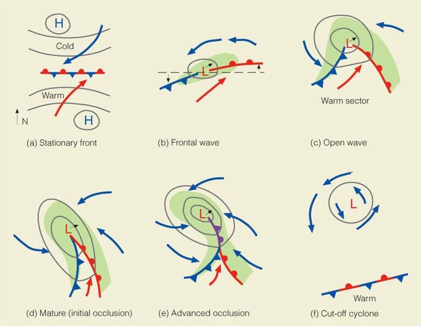
  1. Cold and warm air masses converge and move side by side in opposing directions. The first signs of instability manifest themselves here. This is referred to as an embryo low pressure system.
  2. The warm air mass begins to rise over the cold air, creating a low pressure system. The air masses begin to rotate. Clouds and precipitation form.
  3. The cold front pushes under and lifts, or occludes , the warm front.
  4. Warm air is completely lifted off the surface. The cold air cuts off the supply of warm air. Precipitation and wind subside. The system dissipates.


WEATHER SEQUENCE IN A LOW PRESSURE SYSTEM

Most low pressure systems have a warm and cold front. More mature depressions may also have an occluded front. This section will show what weather one expects as the low pressure system advances across an area of the world.
 

Learn About The Weather

General Circulation of the Atmosphere

General Circulation of the Atmosphere

It has been shown in previous notes, that there is a surplus of energy towards the Equator and a deficit nearer to the poles. In theory, this surplus energy should be transferred to areas with a deficiency of energy by means of a single convective system. This would be the case for a non-rotating Earth.

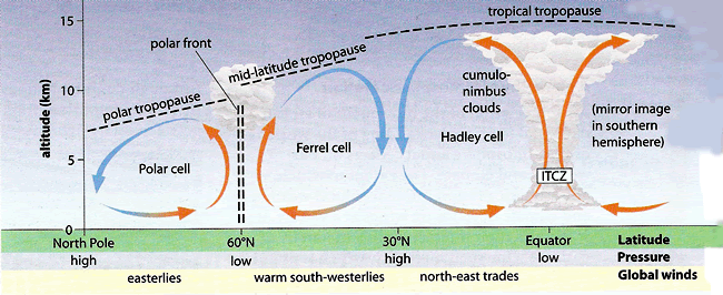
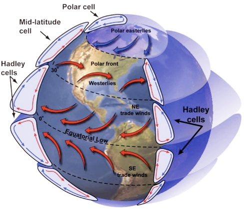
The Sun’s rays hit the Equator directly, causing a consistent flow of warm, rising air in the tropics. This rising air is rapidly cooled to produce the towering cumulonimbus clouds, frequent afternoon thunderstorms and low pressure characteristic of the equatorial climate. This is the reason why rain forests exist at the Equator. As the rising air cools to the temperature of the surrounding air, uplift ceases and it begins to move away from the Equator. Further cooling, increasing density and diversion by the Coriolis force cause the air to slow down and to subside, forming the descending limb of the Hadley Cell https://fr-libido.com/. In looking at the northern hemisphere, it can be seen that the air subsides at 30°N of the Equator to create the sub-tropical high pressure with its clear skies and dry, stable conditions. This is the reason why extensive deserts exist at this latitude. On reaching the Earth’s surface, the cell is completed as some of the air returns to the Equator as the north-east trade winds. The remaining air is diverted pole ward forming the warm south-westerlies which collect moisture when they cross areas of sea. The Maltese Islands are located within the south-westerlies zone. This is why the westerlies are the most common winds direction locally. These warm winds meet cold Arctic air at 60°N of the Equator. This forces the air to rise and form an area of low pressure and the rising limb of both the Ferrel and Polar cells. The resultant unstable conditions produce the heavy-cyclonic rainfall associated with mid-latitude depressions. These depressions are another mechanism by which surplus heat is transferred. While some of this rising air returns to the tropics, some travels towards the poles where, having lost its heat, it descends to form another stable area of high pressure at 90°N of the Equator. This is why the north pole is considered as one of the driest deserts on Earth. Air returning to the polar front is referred to as the cold easterlies.


Learn About The Weather

Atmospheric Pressure

How is wind formed?

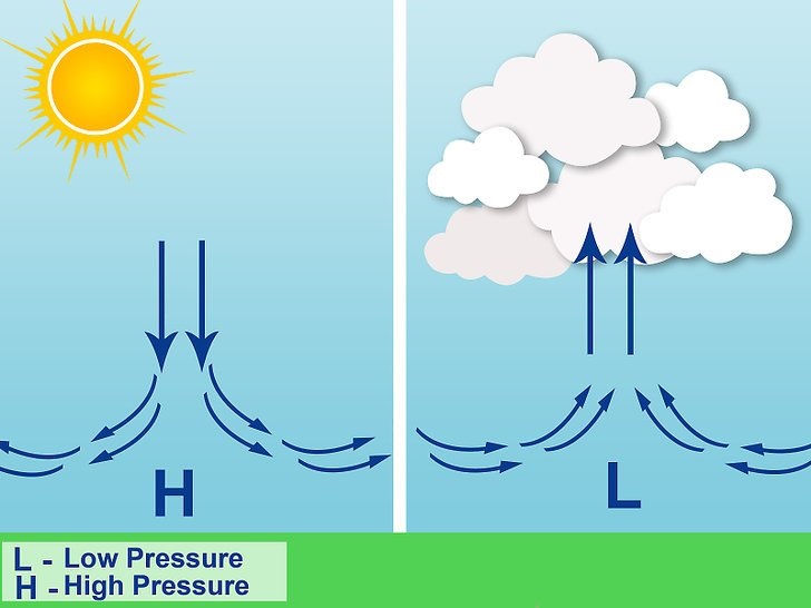
Changes in air pressure and temperature usually start and maintain wind. Generated by differential heating of the Earth’s surface, pressure differences may develop on all scales, from local to global. Warm air is less dense than cold air and tends to rise, reducing the number of air molecules at ground level. This leaves behind a mass deficit, or an area of low pressure. As air cools, it sinks and the number of air molecules at the Earth’s surface increases, forming a region of high pressure. To balance the difference, air flows from high to low pressure, creating wind.


What is atmospheric pressure?

Atmospheric pressure at any particular point is caused by the weight of air molecules above it. As discussed earlier, differences in pressure create wind as the air moves from areas of high to low pressure. Weather experienced on the ground is greatly influenced by atmospheric pressure: high pressure usually produces fine weather, and low pressure creates unsettled, often stormy conditions. Rising air in a low-pressure system, warm air converges at the surface and spirals upward. Rising water vapour cools and condense, forming clouds, and often precipitation. As air molecules are transported downward, high pressure forms at the surface. Descending air warms, causing water droplets to evaporate and clouds to dissipate. Since winds always blow from areas of high pressure to low pressure, a closed circulation system develops.


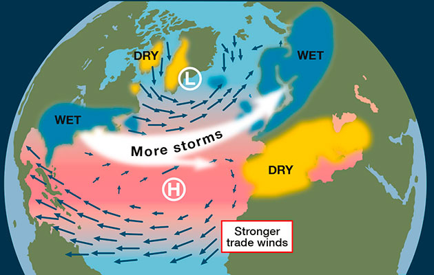
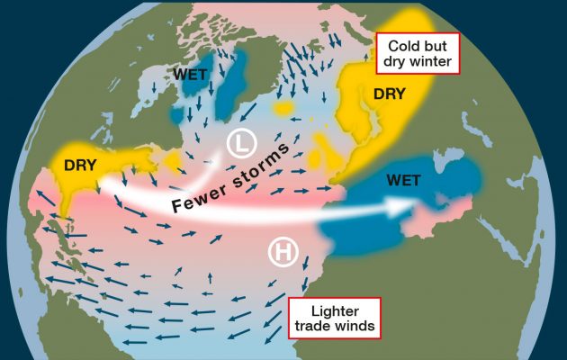
Areas of high and low pressure encircle Earth in defined bands. In equatorial regions, low pressure dominates, but in midlatitudes, large areas of high pressure in both hemispheres. Belts of low pressure systems are found toward the polar regions. Two pressure systems largely influence the climate of the Maltese Islands. These are the Icelandic Low  and the Azores High. The Azores high is a semi-permanent subtropical high is named after the archipelago of the Azores. This region of high pressure gains strength and shifts farther north in summer, occasionally expanding to the northeast, preventing Atlantic storms from reaching Europe. The Icelandic Low is a semi-permanent area of low pressure between Iceland and Greenland. This centre of atmospheric circulation is associated with frequent storm activity and is stronger in winter. The behaviour of the Azores High and Icelandic Low anchor the NAO. If we measure the pressure differences between the Icelandic Low and the Azores High, we see fluctuations in their strengths. We say that there is a positive NAO index when there is a stronger than normal Azores High and a deeper Icelandic low. As storm systems track further north it gives warmer and wetter weather in Europe keeping the most of Europe on the south side of lows in the warmer and wetter south-westerly tropical maritime air. A negative index, on the other hand, is indicated by a less well developed high to the south or low pressure to the north. This weaker pressure gradient and more southerly position of the Azores High means that the winter storms will tend to track further south. This tends to bring unsettled weather into the Mediterranean and southern Europe while the colder, drier air will affect the UK giving us less stormy but drier and colder weather.


In the upcoming note we will be discussing global winds and the general circulation of the atmosphere.

Learn About The Weather

Temperature

What is temperature?

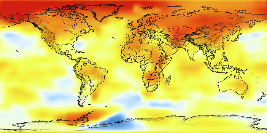
Temperature is a measure of the heat, or average kinetic energy, of molecules in a substance. It is one of the most important weather and climate parameters and determines the heat flow between two different areas of objects. Temperature controls biological activity, the phase state of water and many other physical processes. As discussed in an earlier note, air temperatures around the world are not evenly distributed. The image below depicts this uneven temperature distribution around the globe. Note how the northern Hemisphere (which has a greater area of land) is much warmer than the southern Hemisphere (which has a smaller area of land).


How is temperature measured?

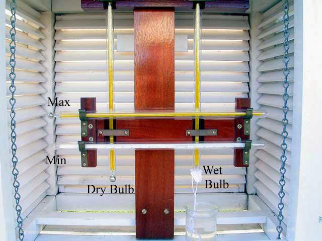
Temperature is measured with thermometers that can be calibrated to a variety of scales. While most countries use the Celsius scale, some still use Fahrenheit. Air temperature is measured with thermometers. Thermometers consist of a glass rod with a very thin tube in it. The tube contains a liquid that is supplied from a reservoir, or “bulb,” at the base of the thermometer. Sometimes the liquid is mercury, and sometimes it is red-coloured alcohol. As the temperature of the liquid in the bulb rises, the liquid expands. As the liquid expands, it rises up in the tube. The tube is marked with a scale, in degrees Fahrenheit or in degrees Celsius. It is important that the thermometer is kept in the shade at all times. Nowadays, air temperature is measured using automatic sensors.


Some global temperature records

  • The highest temperature: Recorded at 56.7 °C on 10 July 1913 in Furnace Creek, California, United States.
  • The coldest temperature: Recorded at -89.2 °C on 21 July 1983 at the Soviet Vostok Station in Antarctica.
Learn About The Weather

The Seasons

Reason for Seasons 

Seasons are distinct periods during the year characterised by annually recurring weather changes. The varying intensity and duration of incoming solar radiation as Earth orbits the Sun, caused by the tilt of Earth’s rotational axis, creates these seasons. Generally, four seasons that differ by temperature – winter, spring, summer and autumn – are observed in mid and polar latitudes. In the tropics, and the subtropics, where solar radiation does not fluctuate much throughout the year, changing precipitation levels produce a dry and a wet season.

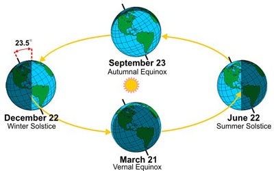
Earth rotates in a counterclockwise direction around an imaginary line, its axis, running between the North and South Poles. Because the axis is tilted at an angle of 23.5 degrees from the vertical, different parts of the planet receive solar radiation in different amounts. This tilt is the reason behind the seasons. Depending on the time of year, some latitude are tilted toward the Sun, while other regions are tilted further away. For half the year, sunlight falls most directly on the Northern Hemisphere; during the other half the Southern Hemisphere. In the Northern Hemisphere, the north pole is tilted away from the Sun in December. Less light reaches the hemisphere then, resulting in short days and low temperatures – in other words; winter. If Earth’s axis was not tilted at all, the Poles would be cold and dark year round. Were the axis tilted more, the seasons would be more extreme.


The Seasons

  1. Winter: Due to colder temperatures, deciduous trees lose their leaves in winter. The same woodland scene for a typical forest in Europe is shown below for the different seasons.
  2. Spring: Rising temperatures and increased sunlight bring the biosphere back to life in spring. Buds and new growth appear on branches and develop into leaves and blossoms.
  3. Summer: Consistently warm weather encourages growth. Photosynthesis converts atmospheric carbon dioxide into sugars using energy from the Sun. Leaves open fully and seed pods form.
  4. Autumn: Decreased temperatures and sunlight in autumn slows biological activity, Trees withdraw chlorophyll (what makes all trees green) and nutrients from their leaves , causing them to change colour before they drop. Pods open and release seeds.

The Maltese Islands enjoy a typical Mediterranean climate. The year is made up of two very different seasons; a hot and dry summer followed by a cool and wet winter. The transition between the two is sudden, but no definite time for when this occurs exists.


Astronomical and Meteorological Seasons

The astronomical definition uses the dates of equinoxes and solstices to mark the beginning and end of the seasons:

  1. Spring begins on the spring equinox (normally 21st March)
  2. Summer begins on the summer solstice (normally 21st June)
  3. Autumn begins on the fall equinox (normally 21st September)
  4. Winter begins on the winter solstice (normally 21st December)

Because the timings of the equinoxes and solstices change each year, the length of astronomical seasons within a year and between years also vary.

According to the meteorological definition, the seasons begin on the first day of the month:

  1. Spring runs from March 1 to May 31st
  2. Summer runs from June 1 to August 31
  3. Autumn runs from September 1 to November 30
  4. Winter runs from December 1 to February 28 (February 29 in a leap year)

Seasons in the Southern Hemisphere are opposite to those in the Northern Hemisphere. Under the definition of astronomical seasons, the June solstice marks the start of summer in the Northern Hemisphere, but it is the start of winter in the Southern Hemisphere. The same rule applies for the other seasons.

In the next post we’ll be dealing with temperature.


Learn About The Weather

The Sun and the Energy Cycle

The Sun

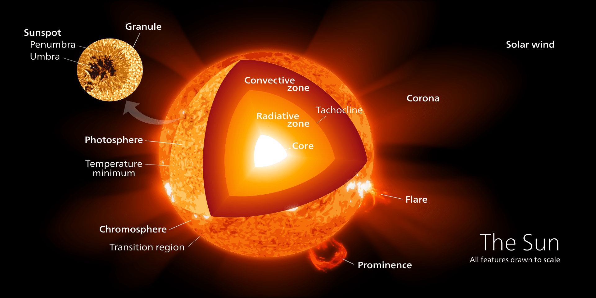
The Sun is the center of our solar system, around which all planets orbit. Like all stars, the Sun is a giant ball of super heated hydrogen gas. Containing 98.6 percent of the solar system’s total mass, the Sun provides nearly all of Earth’s energy as electromagnetic radiation. The absorption, reflection and redistribution of this energy from the Sun fuels Earth’s weather and climate. The Sun’s surface is not firm like Earth’s; it is composed of churning active gases, hot enough to vaporize any solid. The energy produced and emitted by the Sun provides warmth and light for all planets. Its core, containing only seven percent of the Sun’s volume, but half its mass, fuels the star with nuclear fusion. Some features of the Sun’s surface are the following:

  1. Core: Energy is produced by the fusion of hydrogen into helium at 15 million °C in the Sun’s intensely hot core.
  2. Radiative Zone: Energy is transported from the core toward the surface by electromagnetic waves.
  3. Convective Zone: This is the outer portion of the Sun. Energy is carried to the surface by convective motion.
  4. Prominence: Long-lasting arcs of gas erupting from the Sun’s surface, held in place by strong magnetic fields.
  5. Photosphere: The visible surface of the Sun.
  6. Flares: Magnetic storms on the surface release bursts of high-energy particles, gas and radiation.
  7. Sunspots: Dark spots indicate regions of magnetic activity that inhibit convection. Observed with telescopes since the 1600s, sunspot activity fluctuates in 11-year cycles. Sunspot cycles impact the Earth’s climate as the energy emitted by the Sun varies.

The Energy Cycle

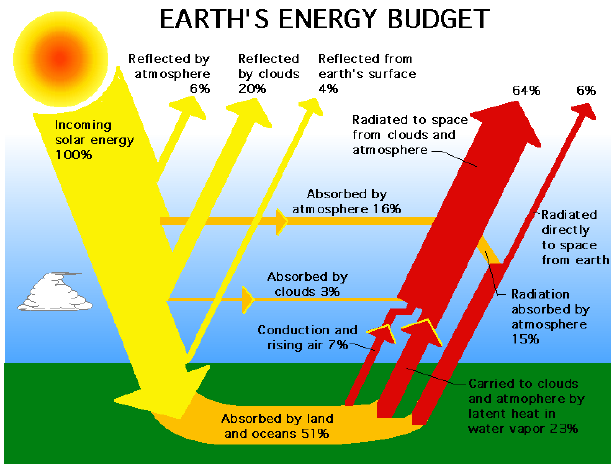
Energy produced by fusion in the Sun’s core reaches Earth as short-wave electromagnetic radiation. After this energy encounters the Earth’s atmosphere, this energy is reflected, absorbed, transformed and radiated back into space in a complex process known as the energy cycle polska-ed.com. The balance between incoming and outgoing radiation results in Earth’s stable temperature. This diagram illustrates solar radiation as it enters and leaves Earth’s atmosphere.

In next week’s post we’ll be dealing with the seasons.


Learn About The Weather

Weather and Climate

What is weather? What is the difference between weather and climate?

Earth is surrounded by a thin envelope of gases, the atmosphere. The term weather is used to describe the state of the atmosphere at a given moment. Weather is the day-to-day state of the atmosphere, and its short-term variation in minutes to weeks. Weather conditions include the distribution and intensity of wind, air pressure, humidity, cloud cover and precipitation among others. Climate is the statistics of these conditions, including their variability, mean and extremes, measured over an extended period of time, often 30 years. We talk about climate change in terms of years, decades, and centuries. Scientists study climate to look for trends or cycles of variability.

The Atmosphere

Earth is a system consisting of five distinct components that permanently interact through the exchange of mass and energy: atmosphere (air), lithosphere (land), hydrosphere (liquid water), cryosphere (ice), and biosphere (life). As a whole, this system is in quasi-equilibrium, fueled by incoming energy from the Sun. Uneven heating of the land and oceans by the Sun is what creates weather.

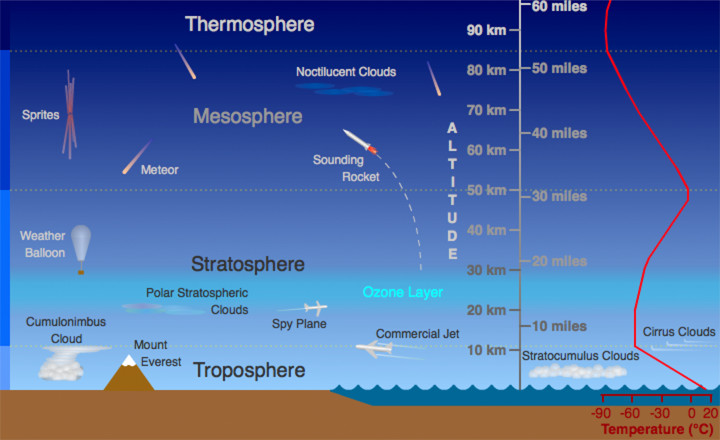
All planets in our solar system have gravitational forces strong enough to maintain an atmosphere. An atmosphere is a mixture of gases that surrounds and protects a planet. Compositions of an atmosphere varies due to gravitational differences. Our Earth too, has an atmosphere. Air density and pressure decrease with height. Earth’s atmosphere consists of distinct layers that are characterized by their temperature profiles: the troposphere, the stratosphere, mesosphere, thermosphere and exosphere. The well-defined boundaries between the layers use the suffix ‘pause’. There is no boundary between the atmosphere and outer space. Molecules become simply more and more rare. These are the different layers of the atmosphere:

  1. Troposphere: The lowest layer reaches from sea-level to 7 kilometers at the Poles, and up to 17 kilometers at the Equator. Being the lowest level of the atmosphere, the troposphere, contains 90% of its mass and the vast majority of atmospheric water. Nearly all weather develops in the troposphere. This layer is characterized by strong convection, a heat-driven process that causes warmer air to rise and cooler air to sink. The base of this layer is warmer than its top because the air is heated by the surface of the Earth, which absorbs the incoming Sun’s energy.
  2. Stratosphere: Above the troposphere lies the stratosphere. This is where jet airplanes fly. The ozone layer lies within the stratosphere. It absorbs harmful ultraviolet rays. Due to absorption of Ultraviolet radiation, in the ozone layer, temperatures in the stratosphere increase with height.
  3. Mesosphere: Frictional heating caused by high air density in the mesosphere incinerates meteors. As this layer extends upward  temperatures decrease. The coldest parts of our atmosphere are located in this layer and can reach –90°C.
  4. Thermosphere: In the forth layer from Earth’s surface, the thermosphere, the air is thin, meaning that there are far fewer air molecules. The thermosphere is very sensitive to solar activity and can heat up to 1,500°C when an aurora is active. Astronauts orbiting Earth in a space station spend their time in this layer.
  5. Exosphere: The upper layer of our atmosphere, where atoms and molecules escape into space, is referred to as the exosphere.

In next week’s post we’ll be dealing with the Sun and the role it plays in the Earth’s Energy Cycle.

Learn About The Weather

Foreword

The weather affects us all. Weather has always been elemental to the course of human history. We have dedicated an area from our website to teach the general public on how the weather works. In this course, we will uncover the processes and mechanics of weather and climate. With clear words and detailed illustrations, we hope to provide you with an interesting and educational read. Interesting topics such as the Earth’s atmosphere, cloud formation, extreme weather events etc … will be examined in great depth.

Starting in February 2019, we will be publishing one post per week ed-hrvatski.com. We hope you’ll enjoy the experience as much as we do.