End of Month Reports

End of Month Reports

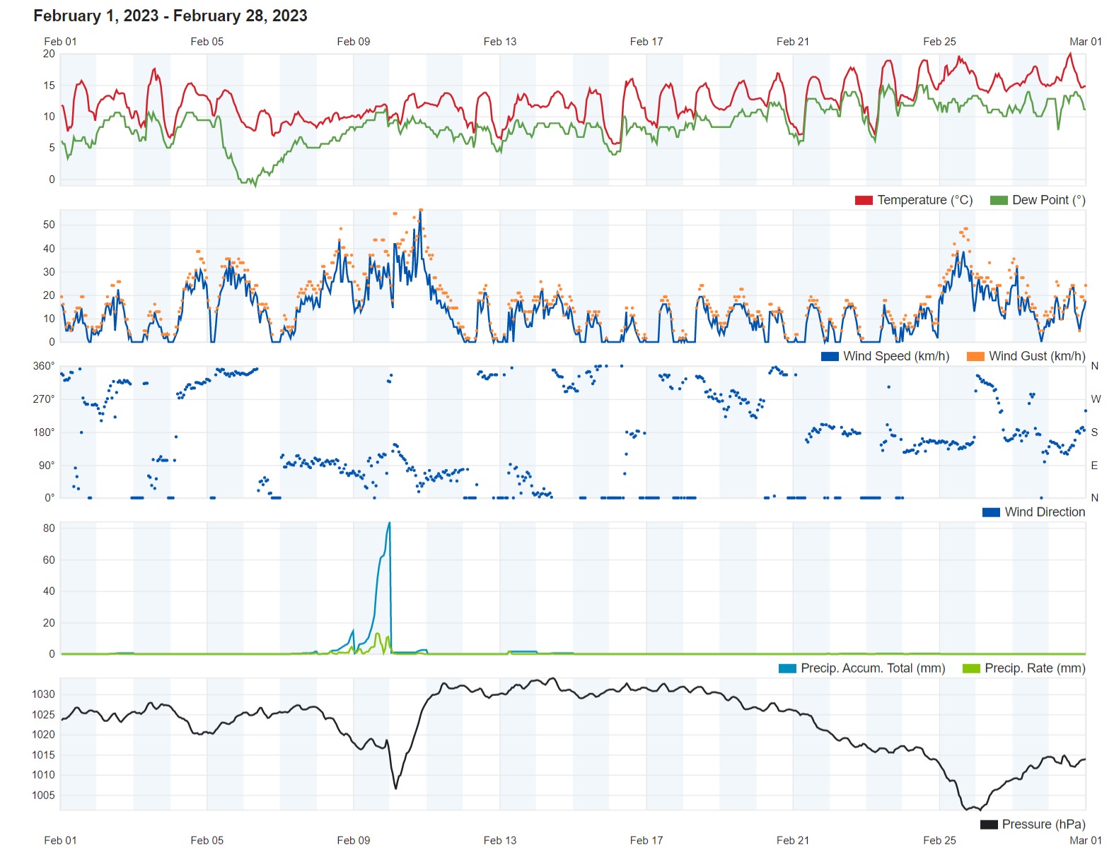
An Eventful February 2023

Air Temperature

Highest Maximum 20.0°C 28th
Lowest Maximum 10.6°C 8th
Highest Minimum 14.6°C 27th
Lowest Minimum 5.1°C 16th


Mean Maximum 15.4°C
Mean Minimum 8.7°C
Mean 12.0°C


Relative Humidity

Highest Relative Humidity 96% Numerous days
Lowest Relative Humidity 40% 5th


Mean Relative Humidity 78.9%


 Wind

Highest Gust 56.3km/h 10th


Mean Wind Speed 9.0km/h
Most Frequent Wind Direction North Northwest


 Atmospheric Pressure

Highest Atmospheric Pressure 1034.0hPa 14th
Lowest Atmospheric Pressure 1000.9hPa 26th


Mean Atmospheric Pressure 1022.8hPa


Precipitation

Total Rainfall During February 2023 149.4 mm
Total Rainfall Since Last 01/09 506.5 mm


Highest 24 Hour Total 121.1 mm 9th


Rain Days 7 days
Thunderstorm Days 2 days
Hail Days 1 day


Rainfall Events

02/02/2023 1.1 mm Light Rain
07/02/2023 3.0 mm Light Rain
08/02/2023 18.7 mm P.M. Steady Rain
09/02/2023 121.1 mm Steady Rain; Thunderstorms
10/02/2023 2.5 mm A.M. Steady Rain; Distant Thunder and Hail
13/02/2023 1.5 mm Light Rain
14/02/2023 0.5 mm Light Rain
21/02/2023 0.3 mm Dew; Fog
22/02/2023 0.2 mm Dew; Fog
23/02/2023 0.3 mm Dew; Fog
24/02/2023 0.2 mm Dew; Fog


February 2023 Compared to the Climate Means

  Climate Mean February 2023 Anomaly
Mean Maximum Temperature 15.6°C 15.4°C -0.2°C
Mean Minimum Temperature 9.7°C 8.7°C -1.0°C
Mean Temperature 12.7°C 12.0°C -0.7°C
Mean Relative Humidity 78.1% 78.9% +0.8%
Mean Atmospheric Pressure 1019.6hPa 1022.8hPa +3.2hPa
Total Rainfall 59.5 mm 149.4 mm +89.9 mm
Total Rainfall Since Last 01/09 495.9 mm 506.5 mm +10.6 mm
Total Rain Days 11 days 7 days -4 days
Total Thunderstorm Days 3 days 2 days -1 day
Total Hail Days 2 days 1 day -1 day


An Eventful FEBRUARY 2023

The third and final month of the 2022/2023 meteorological winter proved to be a very eventful one.

149.4 mm of rain were measured over the course of last February. 95% of this were measured in a staggering 35 hours of incessant rainfall from later in the afternoon on the 8th through to the predawn hours of the 10th. The 9th will be remembered for being the wettest February day on record. This was produced by Storm Helios, an intense Mediterranean cyclone which developed over the central Mediterranean. These 35 hours of intense rainfall also accounted for the two days of thunder and one day of hail recorded last month. The rest of the month was relatively stable.

February 2023 was colder than average overall. Whilst the mean maximum temperature of 15.4°C was only marginally below the climate norm, the mean minimum temperature of 8.7°C was a full degree colder than normal. February’s mean temperature of 12.0°C was 0.7°C lower than the typical value for the time of year. Most nights were colder than average. This could be due to the anticyclonic conditions that maintained clear skies and calm winds overnight, allowing for the cooling of the air. The mercury dipped to its coldest point in the early hours of the 16th, when a chilly 5.1°C was measured. The only exception to the fresh conditions that dominated much of February was the month’s closing week. A current of warm, humid air off the Sahara Desert, formed by the passage of a zone of low pressure across our area. The final day of February 2023 was to be the month’s warmest. The temperature on the 28th shot up to 20°C.

Rounding off the month with a mean of 1022.8hPa, atmospheric pressure was significantly higher than norm. This had a profound impact on the sea-level around the Maltese Islands. The atmospheric pressure shot up from 1005.7hPa (stormy weather) on Friday 10th February to 1032.7hPa (fine weather) on Saturday 11th February. It remained at consistently high levels for a number of days, with the highest values peaking at 1034hPa on the 14th. This spike in atmospheric pressure increased the force the air exerted on the sea. On average, a column of air with a cross-sectional area of 1 square centimeter squared, measured from the sea level to the top of the Earth’s atmosphere, has a mass of approximately 1 kilogram. A 1hPa increase in atmospheric pressure on a regional level temporarily lowers the sea-level by approximately 1 centimeter. When this phenomenon happens on a regional the fall in sea-level is significant. In fact, the temporary fall in sea-level last month was one of the most drastic in recent years.

In the morning of the 23rd, people across the Maltese Islands woke up to widespread fog. This persisted for a long while and caused some delays to flights at the airport. That morning’s fog, termed radiation fog in meteorology, was a product of the great stability the Maltese Islands were experiencing at that point. Radiation fog is formed by the cooling of land after sunset by infrared thermal radiation in calm conditions with a clear sky. The cooling ground cools adjacent air by conduction, causing the air temperature to fall and reach the dew point (the temperature at which an air mass becomes saturated and the water vapor in it condenses), forming fog. Radiation fog occurs at night, and often does not last long after sunrise. That morning’s fog was denser and more persistent than usual for one reason. The land was still wet from the abundant precipitation received from Storm Helios earlier on in February. The moisture available for the formation of fog was far more plentiful than in a typical year.


Rainfall Totals around the Maltese Islands in February 2023 (and since last September 1st):

Għarb: 149.4 mm (506.5 mm)

Victoria: 142.2 mm (450.6 mm)

Xewkija: 126.0 mm (444.4 mm)

Nadur: 139.6 mm (438.2 mm)

Marsalforn: 143.9 mm (467.4 mm)

Mellieħa: 134.7 mm (414.1 mm)

Buġibba: 153.2 mm (494.7 mm)

Mġarr: 129.5 mm (443.4 mm)

Naxxar: 179.0 mm (583.9 mm)

Mosta: 170.1 mm (556.3 mm)

Dingli: 145.2 mm (470.6 mm)

Msida: 202.6 mm (655.0 mm)

Valletta: 133.8 mm (478.1 mm)

Imqabba: 172.2 mm (528.9 mm)

Żabbar: 172.5 mm (535.3 mm)

Birżebbuġa: 151.7 mm (438.0 mm)

Sliema: 167.9 mm (617.9 mm)

NATIONAL MEAN: 153.7 mm (501.3 mm)

End of Month Reports

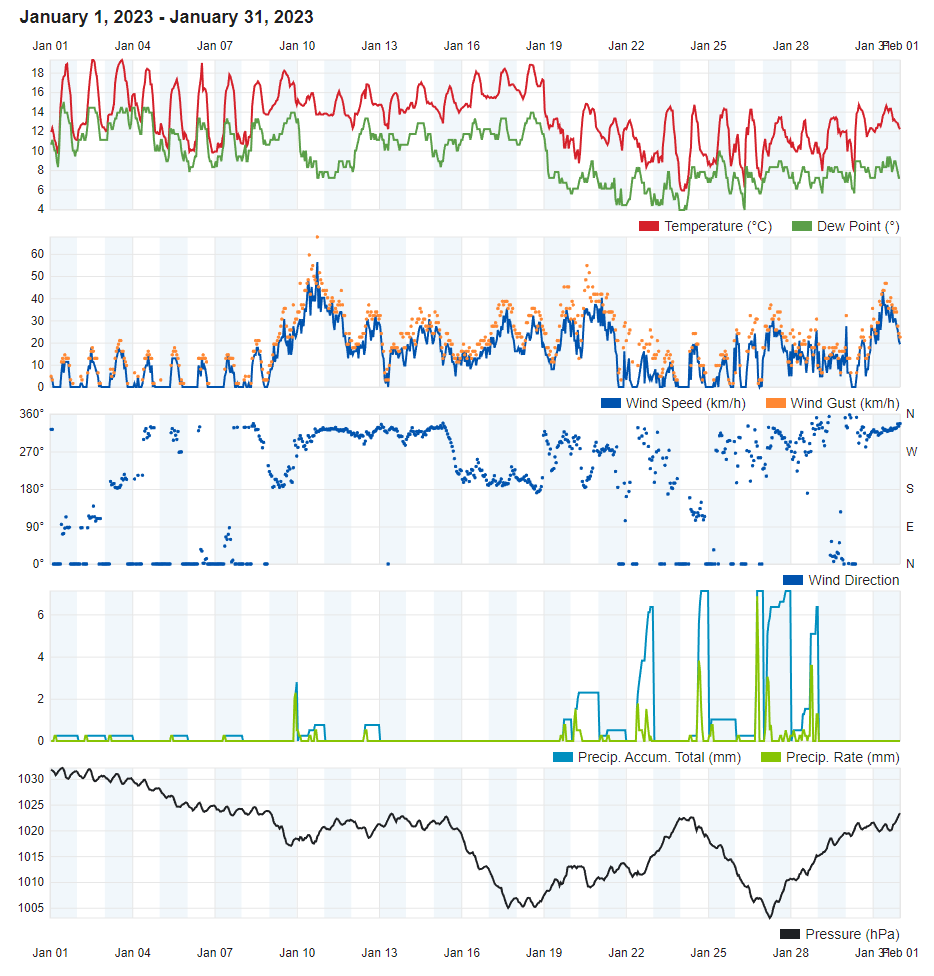
The Two Faces of January 2023

Air Temperature

Highest Maximum 19.3°C 2nd and 3rd
Lowest Maximum 13.1°C 22nd and 28th
Highest Minimum 15.2°C 17th
Lowest Minimum 4.9°C 24th


Mean Maximum 16.2°C
Mean Minimum 10.0°C
Mean 13.1°C


Relative Humidity

Highest Relative Humidity 95% Numerous days
Lowest Relative Humidity 52% 20th


Mean Relative Humidity 78.5%


Wind

Highest Gust 67.6km/h 10th


Mean Wind Speed 10.7km/h
Most Frequent Wind Direction Northwest


Atmospheric Pressure

Highest Atmospheric Pressure 1032.1hPa 1st
Lowest Atmospheric Pressure 1002.6hPa 27th


Mean Atmospheric Pressure 1018.6hPa


Precipitation

Total Rainfall During January 2023 58.4 mm
Total Rainfall Since Last 01/09 357.1 mm


Highest 24 Hour Total 9.8 mm 26th and 27th


Rain Days 15 days
Thunderstorm Days 9 days
Hail Days 6 days


Rainfall Events

01/01/2023 0.3 mm Dew
02/01/2023 0.2 mm Light Rain
03/01/2023 0.3 mm Light Rain
09/01/2023 2.8 mm Rain and Hail Showers
10/01/2023 0.8 mm Rain Showers
12/01/2023 1.8 mm Light Rain
19/01/2023 1.3 mm Rain Showers; Distant Thunder
20/01/2023 3.1 mm A.M. Thunderstorm with Hail
21/01/2023 0.5 mm Light Rain
22/01/2023 9.3 mm Showers and Thunderstorms with Hail
24/01/2023 9.3 mm Steady Rain; Distant Thunder
25/01/2023 0.8 mm A.M. Light Rain; Distant Thunder
26/01/2023 9.8 mm Thunderstorm with Hail
27/01/2023 9.8 mm Thunderstorm; Rain and Hail Showers
28/01/2023 8.3 mm Thunderstorm with Hail; Showers
29/01/2023 0.0 mm Distant Thunder and Hail


January 2023 Compared to the Climate Means

  Climate Mean January 2023 Anomaly
Mean Maximum Temperature 15.6°C 16.2°C  +0.6°C
Mean Minimum Temperature 9.8°C 10.0°C +0.2°C
Mean Temperature 12.7°C 13.1°C +0.4°C
Mean Relative Humidity 79.0% 78.4% -0.6%
Mean Atmospheric Pressure 1018.2hPa 1018.6hPa +0.4hPa
Total Rainfall 94.1 mm 58.4 mm -35.7 mm
Total Rainfall Since Last 01/09 436.4 mm 357.1 mm -79.3 mm
Total Rain Days 14 days 15 days +1 day
Total Thunderstorm Days 4 days 9 days +5 days
Total Hail Days 1 day 6 days +5 days


The Two Faces of January 2023

The New Year started off with bright sunshine, warm temperatures and calm winds. This was the product of a persistent anticyclone that had covered the central Mediterranean since the start of meteorological winter. The anticyclone started fading away slowly, with the second week of January 2023 registering the first gale of the year. An abrupt cold snap bringing typical wintry weather started overnight on the 19th and lasted till the end of the month. This was the result of deep low pressure extending from mainland Europe towards the Mediterranean. It brought colder temperatures and eleven consecutive days with at least one shower being recorded at some point during the day.

Overall, where temperature is concerned, January 2023 turned out to be marginally warmer than average. Last month’s mean temperature of 13.1°C was just under half a degree above the climate norm. An episode of wintry temperatures in the final ten days of the month was not enough to tip the balance in favour of a colder than average trend. The rest of the month was marked by consistently warmer than average temperatures. The maximum temperature for last month was of 19.3°C, measured on both the 2nd and 3rd. In the early hours of the 24th, after a calm, clear and frosty night, the mercury dipped to last month’s coldest point of 4.9°C.

Around half of all days in January 2023 were characterized by showers. The rumbling thunder was heard on a staggering nine days. Hail was registered on six days. This wasn’t enough to produce the amount of rainfall expected in a typical January. In fact, the month’s total of 58.4 mm fell a third short of the climate norm. Although the average for January was not reached, the countryside still got a much-needed boost. For this boost to be enhanced, February needs to give us more of this precious rainfall. The last February to give us more rainfall that average was way back in 2018.

The highest wind gust recorded last month reached 67.6 km/h during a Mistral gale. This was also the first gale of 2023.


Rainfall Totals around the Maltese Islands in January 2023 (and since last September 1st):

Għarb: 58.4 mm (357.1 mm)

Victoria: 49.9 mm (308.4 mm)

Xewkija: 47.6 mm (318.4 mm)

Nadur: 51.6 mm (298.6 mm)

Marsalforn: 47.6 mm (323.5 mm)

Mellieħa: 45.6 mm (279.4 mm)

Buġibba: 64.2 mm (341.5 mm)

Mġarr: 71.0 mm (313.9 mm)

Naxxar: 92.5 mm (404.9 mm)

Mosta: 80.2 mm (386.2 mm)

Dingli: 70.6 mm (325.4 mm)

Msida: 89.4 mm (452.4 mm)

Valletta: 76.1 mm (344.3 mm)

Imqabba: 66.7 mm (356.7 mm)

Żabbar: 75.0 mm (362.8 mm)

Birżebbuġa: 75.7 mm (286.3 mm)

Sliema: 91.5 mm (450.0 mm)

NATIONAL MEAN: 67.9 mm (347.6 mm)

End of Month Reports

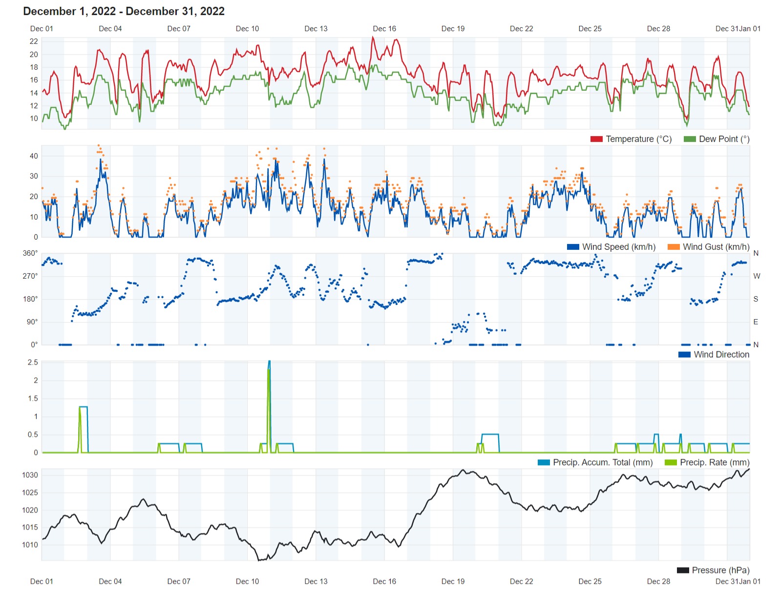
Record-Breaking December 2022

Air Temperature

Highest Maximum 22.6°C 15th
Lowest Maximum 17.2°C 31st
Highest Minimum 17.4°C 9th
Lowest Minimum 9.3°C 21st and 29th


Mean Maximum 19.2°C
Mean Minimum 13.2°C
Mean 16.5°C


Relative Humidity

Highest Relative Humidity 96% Numerous days
Lowest Relative Humidity 59% 5th


Mean Relative Humidity 85.4%


Wind

Highest Gust 45.1km/h 3rd


Mean Wind Speed 8.9km/h
Most Frequent Wind Direction South


Atmospheric Pressure

Highest Atmospheric Pressure 1031.8hPa 31st
Lowest Atmospheric Pressure 1004.8hPa 10th


Mean Atmospheric Pressure 1019.2hPa


Precipitation

Total Rainfall During December 2022 7.0 mm
Total Rainfall Since Last 01/09 298.7 mm


Highest 24 Hour Total 2.5 mm 10th


Rain Days 4 days
Thunderstorm Days 1 days
Hail Days 0 days


Rainfall Events

02/12/2022 1.3 mm Light Showers
06/12/2022 0.2 mm Mist/Fog and Dew
07/12/2022 0.3 mm Light Showers
10/12/2022 2.5 mm Showers; Distant Thunder
11/12/2022 0.2 mm Light Showers
20/12/2022 0.5 mm Mist/Fog and Dew
26/12/2022 0.3 mm Mist/Fog and Dew
27/12/2022 0.5 mm Mist/Fog and Dew
28/12/2022 0.5 mm Mist/Fog and Dew
29/12/2022 0.2 mm Mist/Fog and Dew
30/12/2022 0.3 mm Mist/Fog and Dew
31/12/2022 0.2 mm Mist/Fog and Dew


December 2022 Compared to the Climate Means

  Climate Mean December 2022 Anomaly
Mean Maximum Temperature 17.1°C 19.2°C  +2.1°C
Mean Minimum Temperature 11.8°C 13.2°C +1.4°C
Mean Temperature 14.5°C 16.2°C +1.7°C
Mean Relative Humidity 79% 85.4% +6.4%
Mean Atmospheric Pressure 1017.3hPa 1019.2hPa +1.9hPa
Total Rainfall 109.7 mm 7.0 mm -102.7 mm
Total Rainfall Since Last 01/09 342.3 mm 291.7 mm +59.1 mm
Total Rain Days 14 days 4 days -10 days
Total Thunderstorm Days 4 days 1 day -3 days
Total Hail Days 1 day 0 days -1 day


Record-Breaking DECEMBER 2022

December 2022, the first month of meterological winter and the last month of 2022 shattered long-standing meteorological records.

With a mean temperature of 16.2°C, December 2022 will go down in the record books as the warmest on record. It broke a decades-old record set in the 1960s by a fraction of a degree. Not a single day last month registered maximum temperatures at or below the climate norm of 17.1°C. With a maximum temperature of 22.6°C, the 15th was the warmest day last month. The ‘coolest’ was the 31st with a mild 17.2°C daytime high. Nights were significantly warmer than average too. The mean minimum temperature of 13.2°C exceeded the norm for the time of year by 1.4°C. The minimum temperature dipped to below 10°C on just five nights. Winter is yet to make its prescence felt.

More records were broken where precipitation is concerned. The paltry 7.0 mm measured by our weather station were just a tiny fraction of the 109.7 mm one would normally expect in December. December is statistically the wettest month of the year locally, but in 2022, even August would turn out to have produced more precipitation. December 2022 broke an almost century-old record set in the 1920s to become the driest December yet. If matters were not dire enough, 2.7 mm of this months total came in the form of mist or fog patches and heavy dewfall. Dewfall was heavy enough to measure on a staggering eight days.

The atmosphere above the central Mediterranean and surrounding regions was very stable. This was due to an extensive anticyclone that became stagnant. As one would expect under these conditions, the mean wind speed last month was much lighter than normal. December is renowned for its northwesterly gales. The highest wind speed in December 2022 clocked in at 45.1 km/h, or a mere strong breeze on the Beaufort Scale. The wind blew predominantly from the southerly quadrant.

Another phenomenon worth mentioning from the final month of 2022 was its incredibly high levels of humidity. The mean humidity last month was a damp 85.4%. Levels of humdity failed to drop below the 80% mark on almost half of all days last month.


Rainfall Totals around the Maltese Islands in December 2022 (and since last September 1st):

Għarb: 7.0 mm (298.7 mm)

Victoria: 8.7 mm (258.5 mm)

Xewkija: 4.2 mm (270.8 mm)

Nadur: 7.4 mm (247.0 mm)

Marsalforn: 2.3 mm (275.9 mm)

Mellieħa: 10.6 mm (233.8 mm)

Buġibba: 7.5 mm (277.3 mm)

Mġarr: 4.9 mm (242.9 mm)

Naxxar: 8.6 mm (312.4 mm)

Mosta: 4.3 mm (306.0 mm)

Dingli: 4.9 mm (254.8 mm)

Msida: 4.3 mm (363.0 mm)

Valletta: 5.7 mm (268.2 mm)

Imqabba: 6.4 mm (290.0 mm)

Żabbar: 3.6 mm (287.8 mm)

Birżebbuġa: 9.7 mm (210.6 mm)

Sliema: 5.3 mm (358.5 mm)

NATIONAL MEAN: 6.2 mm (279.7 mm)

End of Month Reports

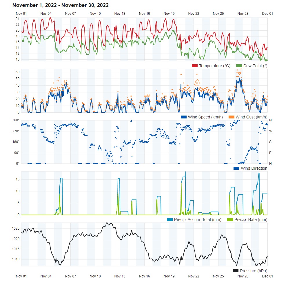
Rain Poured Down in November 2022

Air Temperature

Highest Maximum 24.4°C 4th
Lowest Maximum 15.4°C 30th
Highest Minimum 20.4°C 4th
Lowest Minimum 10.8°C 30th


Mean Maximum 21.1°C
Mean Minimum 15.1°C
Mean 18.1°C


Relative Humidity

Highest Relative Humidity 93% Numerous days
Lowest Relative Humidity 54% 5th


Mean Relative Humidity 79.6%


Wind

Highest Gust 64.4km/h 27th


Mean Wind Speed 11.1km/h
Most Frequent Wind Direction Northwest


Atmospheric Pressure

Highest Atmospheric Pressure 1027.8hPa 11th
Lowest Atmospheric Pressure 1005.4hPa 27th


Mean Atmospheric Pressure 1016.5hPa


Precipitation

Total Rainfall During November 2022 176.8 mm
Total Rainfall Since Last 01/09 291.7 mm


Highest 24 Hour Total 23.5 mm 29th


Rain Days 14 days
Thunderstorm Days 7 days
Hail Days 6 days


Rainfall Events

05/11/2022 21.2 mm Isolated Showers; Thunderstorm with Hail
12/11/2022 21.2 mm Thunderstorm with Hail
13/11/2022 2.4 mm Isolated Shower
14/11/2022 22.1 mm Thunderstorm with Hail
17/11/2022 9.3 mm Shower; Distant Thunder
20/11/2022 21.0 mm Thunderstorm; Isolated Showers
21/11/2022 10.4 mm Showers
22/11/2022 1.4 mm Isolated Showers
23/11/2022 1.8 mm Isolated Showers
24/11/2022 1.8 mm Isolated Showers
26/11/2022 15.9 mm Thunderstorm; Severe Thunderstorm with Hail
27/11/2022 11.7 mm Showers
29/11/2022 23.5 mm Thunderstorms with Hail
30/11/2022 13.1 mm Thunderstorm with Hail


November 2022 Compared to the Climate Means

  Climate Mean November 2022 Anomaly
Mean Maximum Temperature 20.6°C 21.1°C  +0.5°C
Mean Minimum Temperature 14.5°C 15.1°C +0.6°C
Mean Temperature 17.6°C 18.1°C +0.4°C
Mean Relative Humidity 77% 79.6% +2.6%
Mean Atmospheric Pressure 1017.9hPa 1016.5hPa -1.4hPa
Total Rainfall 93.6 mm 176.8 mm +83.2 mm
Total Rainfall Since Last 01/09 232.6 mm 291.7 mm +59.1 mm
Total Rain Days 11 days 14 days +3 days
Total Thunderstorm Days 4 days 7 days +3 days
Total Hail Days 1 day 6 days +5 days


Rain Poured Down in NOVEMBER 2022

The third and last month of meteorological autumn registered almost double the amount in a typical November. A plentiful 176.8 mm were measured by our weather station. Rain fell on a staggering 14 days last month, with the vast majority of these occurring in the second half of the month. Much of last month’s rain was produced by heavy showers which were often accompanied by hail and thunder. 6 of last November’s rainy days also recorded precipitation in hail form. Thunder was heard on 7 days. Out of November’s 14 rainy days, the wettest was the 29th, when 23.5 mm of rainfall were measured in 24 hours. Localities in central Malta were far wetter on that day. Msida and Sliema tallied 93.5 mm and 88.1 mm of rain respectively on that day. This caused intense flooding in the usual low-lying areas. Last month also produced one notable severe rainfall event. This was a severe thunderstorm on the 26th. Hailstones of 2 centimetres diameter were confirmed in Ħ’Attard. Damaging wind gusts were also recorded by weather station in neighboring localities. Rainfall totals in the region of 45 mm were also measured in nearby localities.

November 2022 was also warmer than average. The mean temperature of 18.1°C was almost half a degree warmer than the climate norm for this time of year. All days from the 1st till the 19th were marked by significantly warmer than average daytime temperatures. With a 24.4°C maximum temperature, the 4th was the warmest day last month. The temperature had not cooled down much in the previous night. In fact, that day’s minimum temperature of 20.4°C was a staggering 5.9°C warmer than the climate mean. The meteorological situation cooled down noticeably for the final week of the month, however, as an incursion of colder air from northern Europe engulfed the central Mediterranean.

There were three outbreaks of strong wind last month. The one on the 27th left the biggest impact by far. A severe Gregale that lasted for much of that Sunday caused havoc along the exposed areas of coast. It also disrupted ferry services between the two islands. The highest wind gust recorded at our weather station was of 64.4 km/h (Force 8). An even stronger wind gusts of 96 km/h (Force 10) was measured in more exposed areas.


Rainfall Totals around the Maltese Islands in November 2022 (and since last September 1st):

Għarb: 176.8 mm (291.7 mm)

Victoria: 157.0 mm (249.8 mm)

Xewkija: 171.6 mm (266.6 mm)

Nadur: 139.9 mm (239.6 mm)

Marsalforn: 159.6 mm (273.6 mm)

Mellieħa: 166.3 mm (223.2 mm)

Buġibba: 185.2 mm (269.8 mm)

Mġarr: 171.4 mm (238.0 mm)

Naxxar: 219.3 mm (303.8 mm)

Mosta: 218.7 mm (301.7 mm)

Dingli: 150.0 mm (249.9 mm)

Msida: 259.3 mm (358.7 mm)

Valletta: 192.6 mm (262.5 mm)

Imqabba: 178.1 mm (283.6 mm)

Żabbar: 183.3 mm (284.2 mm)

Birżebbuġa: 124.9 mm (200.9 mm)

Sliema: 267.9 mm (353.2 mm)

NATIONAL MEAN: 183.6 mm (273.5 mm)

End of Month Reports

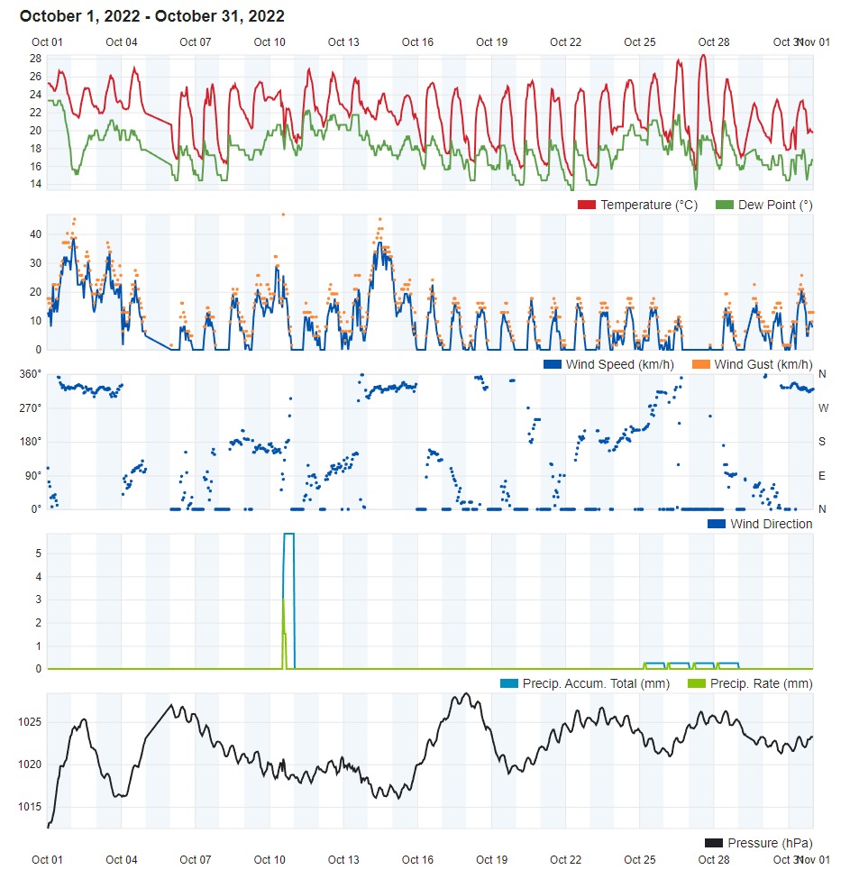
Dry, Warm and Calm in October 2022

Air Temperature

Highest Maximum 28.4°C 27th
Lowest Maximum 23.0°C 29th
Highest Minimum 21.9°C 1st
Lowest Minimum 14.4°C 22nd


Mean Maximum 25.3°C
Mean Minimum 17.9°C
Mean 21.6°C


Relative Humidity

Highest Relative Humidity 95% 28th
Lowest Relative Humidity 43% 26th


Mean Relative Humidity 80.0%


Wind

Highest Gust 46.7km/h 10th


Mean Wind Speed 6.4km/h
Most Frequent Wind Direction East Northeast


Atmospheric Pressure

Highest Atmospheric Pressure 1028.4hPa 17th
Lowest Atmospheric Pressure 1011.9hPa 1st


Mean Atmospheric Pressure 1022.0hPa


Precipitation

Total Rainfall During October 2022 27.7 mm
Total Rainfall Since Last 01/09 114.9 mm


Highest 24 Hour Total 27.7 mm 10th


Rain Days 1
Thunderstorm Days 1
Hail Days 1


Rainfall Events

10/10/2022 27.7 mm Thunderstorm with Hail


October 2022 Compared to the Climate Means

  Climate Mean October 2022 Anomaly
Mean Maximum Temperature 24.8°C 25.3°C  +0.5°C
Mean Minimum Temperature 17.9°C 17.9°C Nil
Mean Temperature 21.4°C 21.6°C +0.2°C
Mean Relative Humidity 78% 80.0% +2.0%
Mean Atmospheric Pressure 1017.4hPa 1022.0hPa +4.6hPa
Total Rainfall 83.3 mm 27.7 mm -55.6 mm
Total Rainfall Since Last 01/09 138.8 mm 114.9 mm -23.9 mm
Total Rain Days 10 days 1 day -9 days
Total Thunderstorm Days 5 days 1 day -4 days
Total Hail Days 1 day 1 day Nil


DRY, WARM and CALM in OCTOBER 2022

With its many days of uninterrupted bright sunshine, continuous days with light and variable winds, and generally warm maximum temperatures, October 2022 didn’t feel like autumn at all.

The month was warmer than the climate norm overall. The mean maximum temperature of 25.3°C surpassed the average by half a degree. Mean minimum temperatures conformed with the climatic norm of 17.9°C. With a maximum temperature of 28.4°C, the 27th was October 2022’s warmest day. The mercury hovered close to the 30°C in certain localities on that day. The coolest day of the month was to be registered a mere 48 hours later, however, with the maximum temperature on the 29th rising to 23°C. Weather during the second half of October was shaped by an anticyclone that spanned much of the Mediterranean region. Anticyclonic conditions promote clear and calm conditions. This allows heat to be lost from the surface of the Earth to space by radiation, allowing temperatures to fall steady overnight. Temperatures typically reach the minimum just before dawn, after a night of cooling. Since cold air sinks, and due to the moderating effect of the sea, the coldest spots are inland low-lying plains and valleys. The freshest night was that of the 22nd, with a minimum temperature of 14.4°C.

October 2022 was also much drier than usual. The 27.7 mm of precipitation measured by the rain gauage at our weather station fell 55.6 mm short of the rainfall expected over the course of a typical October. To aggravate matters, this precipitation was produced by a single heavy thunderstorm at around lunchtime on the 10th. This rainfall event was to be the sole rain day last month. The thunderstorm on the 10th also accounted for the highest wind gust measured last month. This clocked in at 46.7km/h from a Northerly direction.

October 2022 will also be remembered for its unprecedented episodes of calm. Wind in the Maltese Islands is very common because it is an island in the middle of the mid-latitude depressions’ path and in a band of pressure difference. On average, 92% of all days experience winds of at least Force 2. This means that only 25 days a year are windless. For a total of 15 consecutive days, from the 16th through to the 30th (both days included), the wind speed averaged 1.7km/h (Force 1). No wind gusts were reported for days on end, with the highest wind speed registered then being of only 17.7km/h (Force 3). Strong wind events were largely absent. The wind direction varied widely, with the East Northeast direction coming out on top in the end.

Not surprisingly, the value for mean atmospheric pressure exceeded the October norm by a fair amount. The 1022.0hPa value was not only 4.6hPa more stable than normal, but also one of the highest for any October.

Rainfall Totals around the Maltese Islands in October 2022 (and since last September 1st):

Għarb: 27.7 mm (114.9 mm)

Victoria: 18.9 mm (92.8 mm)

Xewkija: 19.0 mm (95.0 mm)

Nadur: 14.7 mm (99.7 mm)

Marsalforn: 33.5 mm (114.0 mm)

Mellieħa: 18.0 mm (56.9 mm)

Buġibba: 19.3 mm (84.6 mm)

Mġarr: 15.8 mm (66.6 mm)

Naxxar: 18.5 mm (84.5 mm)

Mosta: 18.3 mm (83.0 mm)

Dingli: 17.3 mm (99.9 mm)

Msida: 24.6 mm (99.4 mm)

Valletta: 19.3 mm (69.9 mm)

Imqabba: 18.8 mm (105.5 mm)

Żabbar: 22.1 mm (100.9 mm)

Birżebbuġa: 16.6 mm (76.0 mm)

Sliema: 19.5 mm (85.3 mm)

NATIONAL MEAN: 20.1 mm (89.9 mm)

End of Month Reports

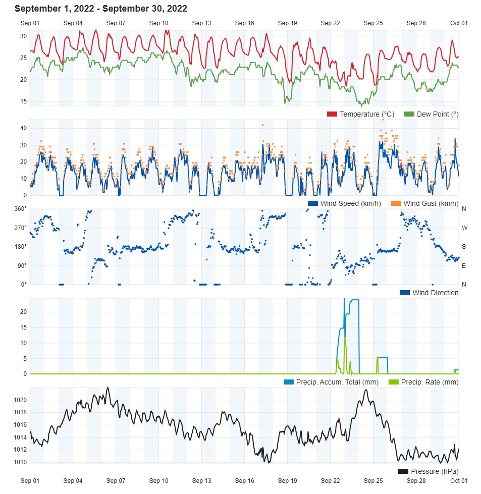
Warmer and Wetter in September 2022

Air Temperature

Highest Maximum 31.3°C 5th and 10th
Lowest Maximum 23.9°C 23rd
Highest Minimum 26.8°C 9th
Lowest Minimum 17.3°C 23rd


Mean Maximum 28.8°C
Mean Minimum 22.8°C
Mean 25.8°C


Relative Humidity

Highest Relative Humidity 94% 10th and 23rd
Lowest Relative Humidity 46% 24th


Mean Relative Humidity 77.1%


Wind

Highest Gust 45.1km/h 25th


Mean Wind Speed 9.7km/h
Most Frequent Wind Direction South


Atmospheric Pressure

Highest Atmospheric Pressure 1022.0hPa 6th
Lowest Atmospheric Pressure 1008.6hPa 17th


Mean Atmospheric Pressure 1015.1hPa


Precipitation

Total Rainfall During September 2022 87.2 mm
Total Rainfall Since Last 01/09 87.2 mm


Highest 24 Hour Total 40.9 mm 22nd


Rain Days 4
Thunderstorm Days 3
Hail Days 0


Rainfall Events

22/9/2022 40.9 mm Steady Light Rain; P.M. Thunderstorm
23/9/2022 39.2 mm A.M. Thunderstorm
25/9/2022 5.7 mm A.M. Showers
30/9/2022 1.4 mm P.M. Shower; Distant Thunder


September 2022 Compared to the Climate Means

  Climate Mean September 2022 Anomaly
Mean Maximum Temperature 28.3°C 28.8°C  +0.5°C
Mean Minimum Temperature 20.8°C 22.8°C +2.0°C
Mean Temperature 24.6°C 25.8°C +1.2°C
Mean Relative Humidity 77% 77.1% +0.1%
Mean Atmospheric Pressure 1017.4hPa 1015.1hPa -3.3hPa
Total Rainfall 55.5 mm 87.2 mm +1.1 mm
Total Rainfall Since Last 01/09 55.5 mm 87.2 mm +0.4 mm
Total Rain Days 3 days 4 days +1 day
Total Thunderstorm Days 1 day 3 days +3 days
Total Hail Days 1 day 0 days Nil


WARMER and WETTER in SEPTEMBER 2022

The first month of meteorological autumn was marked by significantly warmer than average temperatures. The mean maximum temperature of 28.8°C and the minimum temperature of 22.8°C exceeded the climate norm by 0.5°C and 2.0°C respectively. The first twenty days were all warmer than average. Temperatures cooled down to average or below average upon the arrival of a colder air mass from northern Europe on the 21st. September 2022 maintained the warmer than average trend started in late spring. Despite this, no extremes were registered last month.

September 2022 produced 87.2 mm of precipitation at our weather station in Għarb. That is significantly more than what one would expect in a typical September. September is normally a hit-or-miss month for rain-bearing systems around the central Mediterranean. In fact, 92% of last month’s total precipitation fell within 24 hours, from late morning on the 22nd till late morning on the 23rd. There were an additional two days of rain, with both registering a brief but intense shower. No severe phenomena were observed in September 2022.

The final ten days of the month were noticeably more unsettled, with most days featuring a cloudier sky, breezier conditions and cooler temperatures.

Rainfall Totals around the Maltese Islands in September 2022 (and since last September 1st):

Għarb: 87.2 mm (87.2 mm)

Victoria: 73.9 mm (73.9 mm)

Xewkija: 73.4 mm (73.4 mm)

Nadur: 85.0 mm (85.0 mm)

Marsalforn: 80.5 mm (80.5 mm)

Mellieħa: 38.9 mm (38.9 mm)

Buġibba: 65.5 mm (65.5 mm)

Mġarr: 50.8 mm (50.8 mm)

Naxxar: 66.0 mm (66.0 mm)

Mosta: 64.7 mm (64.7 mm)

Dingli: 82.6 mm (82.6 mm)

Msida: 74.8 mm (74.8 mm)

Valletta: 50.6 mm (50.6 mm)

Imqabba: 86.7 mm (86.7 mm)

Żabbar: 78.8 mm (78.8 mm)

Birżebbuġa: 59.4 mm (59.4 mm)

Sliema: 65.8 mm (65.8 mm)

NATIONAL MEAN: 69.9 mm

End of Month Reports

Hotter but Wetter in August 2022

Air Temperature

Highest Maximum 38.3°C 17th
Lowest Maximum 29.1°C 25th
Highest Minimum 28.0°C 18th
Lowest Minimum 21.1°C 24th


Mean Maximum 31.4°C
Mean Minimum 23.9°C
Mean 27.6°C


 Relative Humidity

Highest Relative Humidity 94% 17th
Lowest Relative Humidity 25% 17th


Mean Relative Humidity 76.6%


 Wind

Highest Gust 43.5km/h 19th


Mean Wind Speed 8.5km/h
Most Frequent Wind Direction Northwest


Atmospheric Pressure

Highest Atmospheric Pressure 1018.9hPa 30th
Lowest Atmospheric Pressure 1008.2hPa 22nd


Mean Atmospheric Pressure 1013.3hPa


Precipitation

Total Rainfall During August 2022 9.7 mm
Total Rainfall Since Last 01/09 586.0 mm


Highest 24 Hour Total 5.1 mm 11th


Rain Days 2
Thunderstorm Days 3
Hail Days 0


 Rainfall Events

10/8/2022 4.6 mm Showers, Thunder in Vicinity
11/8/2022 5.1 mm Showers, Thunder in Vicinity, Waterspouts
12/8/2022 0.0 mm Thunder in Vicinity


August 2022 Compared to the Climate Means

  Climate Mean August 2022 Anomaly
Mean Maximum Temperature 31.4°C 31.4°C Nil
Mean Minimum Temperature 22.7°C 23.9°C +1.2°C
Mean Temperature 27.1°C 27.6°C +0.5°C
Mean Relative Humidity 73% 76.6% +3.6%
Mean Atmospheric Pressure 1015.4hPa 1013.3hPa +2.1hPa
Total Rainfall 8.6 mm 9.7 mm +1.1 mm
Total Rainfall Since Last 01/09 585.6 mm 586.0 mm +0.4 mm
Total Rain Days 1 day 2 days +1 day
Total Thunderstorm Days 0 days 3 days +3 days
Total Hail Days 0 days 0 days Nil


HOTTER but WETTER in AUGUST 2022


The third and final month of the meteorological summer completed a whole season of hotter than average temperatures. The mean maximum temperature of 31.4°C conformed with the climate norm. The mean minimum temperature of 23.9°C exceeded the norm by a staggering 1.2°C. Overall, August 2022’s mean temperature of 27.6°C was half a degree warmer than the climate average for a typical August. This anomaly in minimum temperatures could be directly attributed to a very warm central Mediterranean Sea (with a sea surface temperature of 28°C to 29°C). A very warm sea inhibits nighttime cooling of air across land areas. Despite maximum temperatures being around the norm for the time of year, elevated levels of relative humidity made for some very uncomfortable days. Relative humidity averaged 76.6% overall, with the level failing to drop below 50% on most days. The heat index exceeded 40°C on a number of days. The heat index is what the air temperature actually feels like to the human body when relative humidity is combined with air temperature in the shade. A number of rain showers drenched zones of the Maltese Islands around the 10th and 11th. Much of the rain that fell in these showers evporated from the soil and vegetation in the following days, causing levels of relative humidity to spike. Last month also accounted for the hottest day and night recorded at our weather station over the course of this year’s meteorological summer. The mercury hit a sweltering 38.3°C on the 17th. It dipped to only 28.0°C the following night.

August 2022 was a very interesting month with regards to precipitation. Despite the intense heat that dominated much of last month, it was a rather unstable month. Towering cumulus clouds featured on the vast majority of days. The air closer to the surface was hot and humid. Simultaneously, cold air was present in the upper levels of the atmosphere. On sunlit days, the hot and humid air is forced to rise. Upon reaching the colder air aloft, moisture within the air mass condenses to form dense clouds. These clouds start forming in the late morning and dissipate by the late afternoon, peaking in the mid-afternoon. These clouds generated some intense thunderstorms from 10th to 12th August. Various localities around the Maltese Islands experienced showers. A handful of localities were drenched by intense downpours. Localities to the south of Malta remained largely dry. Total precipitation tallied at a national average of 22.2 mm. A few localities received in excess of two inches (or 50 mm) of precipitation.

Rainfall Totals around the Maltese Islands in August 2022 (and since last September 1st):

Għarb: 9.7 mm (586.0 mm)

Victoria: 18.1 mm (615.3 mm)

Xewkija: 11.4 mm (562.6 mm)

Nadur: 7.4 mm (626.8 mm)

Marsalforn: 3.6 mm (629.4 mm)

Mellieħa: 44.2 mm (587.8 mm)

Buġibba: 31.8 mm (651.7 mm)

Mġarr: 52.3 mm (644.1 mm)

Naxxar: 56.4 mm (688.1 mm)

Mosta: 61.7 mm (605.5 mm)

Dingli: 2.0 mm (497.1 mm)

Msida: 33.3 mm (627.7 mm)

Valletta: 13.6 mm (384.6 mm)

Imqabba: 12.4 mm (592.8 mm)

Żabbar: 12.0 mm (607.5 mm)

Birżebbuġa: 0.8 mm (432.6 mm)

Sliema: 16.8 mm (594.9mm)

NATIONAL MEAN: 22.8 mm (584.8 mm)

End of Month Reports

Hotter than Average in July 2022

Air Temperature

Highest Maximum 36.8°C 5th
Lowest Maximum 28.4°C 10th
Highest Minimum 26.3°C 26th
Lowest Minimum 19.1°C 17th


Mean Maximum 31.9°C
Mean Minimum 23.4°C
Mean 27.7°C


Relative Humidity

Lowest Relative Humidity 25% 6th


Mean Relative Humidity 69.1%


Wind

Highest Gust 45.1km/h 8th


Mean Wind Speed 7.7km/h
Most Frequent Wind Direction Northwest


Atmospheric Pressure

Highest Atmospheric Pressure 1021.6hPa 12th
Lowest Atmospheric Pressure 1008.6hPa 27th


Mean Atmospheric Pressure 1015.9hPa


Precipitation

Total Rainfall During July 2022 0.0 mm
Total Rainfall Since Last 01/09 576.3 mm


Highest 24 Hour Total Nil Nil


Rain Days 0 days
Thunderstorm Days 0 days
Hail Days 0 days


July 2022 Compared to the Climate Means

  Climate Mean July 2022 Anomaly
Mean Maximum Temperature 31.2°C 31.9°C +0.7°C
Mean Minimum Temperature 21.8°C 23.4°C +1.6°C
Mean Temperature 26.5°C 27.7°C +1.2°C
Mean Relative Humidity 69.0% 69.1% +0.1%
Mean Atmospheric Pressure 1015.7hPa 1015.9hPa +0.2hPa
Total Rainfall 0.3 mm 0.0 mm -0.3 mm
Total Rainfall Since Last 01/09 576.4 mm 576.3 mm -0.1 mm
Total Rain Days 0 days 0 days Nil
Total Thunderstorm Days 0 days 0 days Nil
Total Hail Days 0 days 0 days Nil


HOTTER THAN AVERAGE in JULY 2022

July 2022, the second month of meteorological summer, was marked by hotter than average temperatures. Whilst no extreme heat waves were recorded, the maximum temperature did exceed the climate norm of 31.2°C on eighteen days. Whilst daytime maximum temperatures were 0.7°C warmer than the norm, nighttime minimum temperatures exceeded the climate average by a staggering 1.6°C. This could be attributed to a warmer than average sea around the central Mediterranean. A very warm sea inhibits nighttime cooling of air on land. Nights did in fact feel very warm, offering meagre relief after a hot day. The air temperature at our Gozo weather station peaked at 36.8°C on the 5th. A handful of localities on mainland Malta registered maximum temperatures in the region of 39°C.

The sea surface temperature around the Maltese Islands surged to 28°C / 29°C as the month progressed.

Whilst it was bone dry at our Gozo weather station, July 2022 proved to be more interesting in terms of precipitation for a number of localities in Malta. A national mean of 0.3 mm was measured by rain gauges distributed in a number of localities around the Maltese Islands. The wettest area was around Dingli. Other localities around central Malta also received some rain. Isolated showers developed over Malta on the 10th and the 14th. That week was characterized by instability. A pocket of cold air was present in the upper levels of the atmosphere over the Maltese Islands. The air at lower levels was substantially warmer and more humid. This state of affairs rendered the atmosphere unstable. As the sun heated the land, the warm and humid air at the surface was forced to rise. This caused the water vapour to condense, forming rain clouds. Cloudbuilding started early in the day, and the clouds reached a size large enough to produce an isolated shower. This episode of instability that spanned the entire second week of July also claimed the highest wind gust measured last month, a 45.1 km/h (Force 6) wind gust from the North Northwest on a breezy day on the 8th.

Rainfall Totals around the Maltese Islands in July 2022 (and since last September 1st):

Għarb: 0.0 mm (576.3 mm)

Victoria: 0.0 mm (597.2 mm)

Xewkija: 0.0 mm (551.2 mm)

Nadur: 0.0 mm (619.4mm)

Marsalforn: 0.0 mm (625.8 mm)

Mellieħa: 0.0 mm (543.6 mm)

Buġibba: 0.0 mm (619.9 mm)

Mġarr: 0.0 mm (591.8 mm)

Naxxar: 0.0 mm (631.7 mm)

Mosta: 0.5 mm (543.8 mm)

Dingli: 3.8 mm (495.1 mm)

Msida: 0.0 mm (594.4 mm)

Valletta: 0.0 mm (371.0 mm)

Imqabba: 0.4 mm (580.4 mm)

Żabbar: 0.0 mm (595.5 mm)

Birżebbuġa: 0.0 mm (431.8 mm)

Sliema: 0.0 mm (578.1mm)

NATIONAL MEAN: 0.3 mm (562.0 mm)

End of Month Reports

Dry and Significantly Hotter than Average in June 2022

Air Temperature

Highest Maximum 35.9°C 26th
Lowest Maximum 24.3°C 10th
Highest Minimum 26.7°C 27th
Lowest Minimum 18.2°C 3rd


Mean Maximum 30.9°C
Mean Minimum 21.4°C
Mean 26.2°C


Relative Humidity

Lowest Relative Humidity 17% 25th


Mean Relative Humidity 61.8%


 Wind

Highest Gust 45.1km/h 10th


Mean Wind Speed 8.8km/h
Most Frequent Wind Direction Northwest


Atmospheric Pressure

Highest Atmospheric Pressure 1019.5hPa 15th
Lowest Atmospheric Pressure 1008.9hPa 10th


Mean Atmospheric Pressure 1015.3hPa


Precipitation

Total Rainfall During June 2022 0.0 mm
Total Rainfall Since Last 01/09 576.3 mm


Highest 24 Hour Total Nil Nil


Rain Days 0 days
Thunderstorm Days 0 days
Hail Days 0 days


June 2022 Compared to the Climate Means

  Climate Mean June 2022 Anomaly
Mean Maximum Temperature 28.2°C 30.9°C +2.7°C
Mean Minimum Temperature 19.3°C 21.4°C +2.1°C
Mean Temperature 23.8°C 26.2°C +2.4°C
Mean Relative Humidity 71% 61.8% -9.2%
Mean Atmospheric Pressure 1015.8hPa 1015.3hPa -0.5hPa
Total Rainfall 4.4 mm 0.0 mm -4.4 mm
Total Rainfall Since Last 01/09 576.1 mm 576.3 mm +0.2 mm
Total Rain Days 1 day 0 days -1 day
Total Thunderstorm Days 0 days 0 days Nil
Total Hail Days 0 days 0 days Nil


DRY and SIGNIFICANTLY HOTTER THAN AVERAGE in JUNE 2022

June 2022, the first month of meteorological summer, was marked by significantly hotter than average and bone dry weather.

With the mean temperature a staggering 2.4°C warmer than the climatic mean, last June was the warmest in decades. There was one heat spell at the start of the month and a heat wave towards the end of the month (24th till 31st). By definition, a heat wave is defined as a spell of three of more consecutive days with maximum temperatures exceeding the mean maximum temperature for that particular time of year by 5°C or more. A heat spell is any episode of intense heat that doesn’t satisfy the criteria for a heat wave. The hottest day last month was the 26th, when the mercury soared to 35.9°C at our weather station. It was hotter elsewhere around the Maltese Islands. With a maximum temperature of 39°C, the 28th was the hottest day nationally. A period of seasonal weather, with temperatures at or slightly above the norm, was experienced halfway through June.

There was nothing to report in terms of rainfall. June 2022 was bone dry. It was also relatively calm regionally, with no thunderstorms observed in territorial waters.

As the first month of meteorological summer, it also lived up to its expectation of being a calm month. There was only one episode of windy weather. Its peak was on the 10th, when a wind gust of 45.2 km/h (Force 6) was measured.

Rainfall Totals around the Maltese Islands in June 2022 (and since last September 1st):

Għarb: 0.0 mm (576.3 mm)

Victoria: 0.0 mm (597.2 mm)

Xewkija: 0.0 mm (551.2 mm)

Nadur: 0.0 mm (619.4mm)

Marsalforn: 0.0 mm (625.8 mm)

Mellieħa: 0.0 mm (543.6 mm)

Buġibba: 0.0 mm (619.9 mm)

Mġarr: 0.0 mm (591.8 mm)

Naxxar: 0.0 mm (631.7 mm)

Mosta: 0.0 mm (543.3 mm)

Dingli: 0.0 mm (491.3 mm)

Msida: 0.0 mm (594.4 mm)

Valletta: 0.0 mm (371.0 mm)

Imqabba: 0.0 mm (580.0 mm)

Żabbar: 0.0 mm (595.5 mm)

Birżebbuġa: 0.0 mm (431.8 mm)

Sliema: 0.0 mm (578.1mm)

NATIONAL MEAN: 0.0 mm (561.7 mm)

End of Month Reports

Wetter but Marginally Warmer in May 2022

Air Temperature

Highest Maximum 31.9°C 26th
Lowest Maximum 17.9°C 1st
Highest Minimum 21.4°C 25th
Lowest Minimum 12.3°C 12th


Mean Maximum 24.1°C
Mean Minimum 16.2°C
Mean 20.1°C


Relative Humidity

Lowest Relative Humidity 17% 24th


Mean Relative Humidity 73.3%


Wind

Highest Gust 46.7km/h 27th


Mean Wind Speed 14.3km/h
Most Frequent Wind Direction South Southeast


Atmospheric Pressure

Highest Atmospheric Pressure 1029.0hPa 20th
Lowest Atmospheric Pressure 1005.8hPa 29th


Mean Atmospheric Pressure 1016.7hPa


Precipitation

Total Rainfall During May 2022 20.1 mm
Total Rainfall Since Last 01/09 576.3 mm


Highest 24 Hour Total 12.6 mm 29th


Rain Days 5 days
Thunderstorm Days 2 days
Hail Days 1 day


Rainfall Events

01/05/2022 0.8 mm Light Rain
02/05/2022 0.3 mm Light Rain
08/05/2022 6.1 mm Rain Shower; Distant Thunder
09/05/2022 0.3 mm Light Rain
29/05/2022 12.6 mm Rain Shower; Distant Thunder and Hail


May 2022 Compared to the Climate Means

  Climate Mean May 2022 Anomaly
Mean Maximum Temperature 23.9°C 24.1°C +0.2°C
Mean Minimum Temperature 15.7°C 16.2°C +0.5°C
Mean Temperature 19.8°C 20.1°C +0.3°C
Mean Relative Humidity 74% 73.3% -0.7%
Mean Atmospheric Pressure 1015.3hPa 1016.7hPa +1.4hPa
Total Rainfall 10.6 mm 20.1 mm +9.5 mm
Total Rainfall Since Last 01/09 571.7 mm 576.3 mm +4.6 mm
Total Rain Days 3 days 5 days +2 days
Total Thunderstorm Days 1 days 2 days +1 day
Total Hail Days 0 days 1 day -1 day


WETTER but MARGINALLY WARMER in MAY 2022

May 2022 was marked by the gradual rise in air temperatures which is synonymous with late spring. Overall, it was marginally warmer than average. The mean temperature of 20.1°C was 0.3°C warmer than the climate mean. The 17th was the warmest day last month. A maximum temperature of 31.9°C was measured on that day. No temperature extremes were recorded over the course of the month.

May 2022 was wetter than normal. The 12.2 mm measured across the Maltese Islands was a fraction higher than what one would normally expect in May. The majority was produced by two rainfall events: on the 8th and 29th. Both rainfall events produced a brief episode of heavy rain. Thunder was heard on both days too. Some small hail was also reported on the 29th. A few days with light rain along with abundant fine desert sand were also reported. The wetter than average weather was due to prevalent instability across the central Mediterranean.

May 2022 lived up to its expectation of being a relatively breezy month. In fact, half of all days last month featured wind of at least Force 5 at times.


Rainfall Totals around the Maltese Islands in May 2022 (and since last September 1st):

Għarb: 20.1 mm (576.3 mm)

Victoria: 20.4 mm (597.2 mm)

Xewkija: 16.6 mm (551.2 mm)

Nadur: 8.9 mm (619.4mm)

Marsalforn: 12.4 mm (625.8 mm)

Mellieħa: 6.2 mm (543.6 mm)

Buġibba: 9.9 mm (619.9 mm)

Mġarr: 12.5 mm (591.8 mm)

Naxxar: 8.8 mm (631.7 mm)

Mosta: 17.2 mm (543.3 mm)

Dingli: 10.0 mm (491.3 mm)

Msida: 10.2 mm (594.4 mm)

Valletta: 7.7 mm (371.0 mm)

Imqabba: 15.2 mm (580.0 mm)

Żabbar: 12.0 mm (595.5 mm)

Birżebbuġa: 9.1 mm (431.8 mm)

Sliema: 9.8 mm (578.1mm)

NATIONAL MEAN: 12.2 mm (561.7 mm)