End of Month Reports

End of Month Reports

Hotter September 2020

Air Temperature

Highest Maximum 32.1°C 10th
Lowest Maximum 24.3°C 26th
Highest Minimum 24.8°C 4th 
Lowest Minimum 19.4°C 14th


Mean Maximum 28.4°C
Mean Minimum 22.9°C
Mean 25.7°C


Relative Humidity

Highest Relative Humidity 95% 14th
Lowest Relative Humidity 45% 26th


Mean Relative Humidity 74.7%


Atmospheric Pressure

Highest Atmospheric Pressure 1023.4hPa 4th
Lowest Atmospheric Pressure 1005.1hPa 27th


Mean Atmospheric Pressure 1015.7hPa


Wind

Highest Gust 61.2km/h 26th


Mean Wind Speed 8.5km/h
Mean Gust Speed 16.7km/h
Mean Wind + Gust Speed 12.6km/h
Most Frequent Wind Direction Northwest


Precipitation

Total Rainfall During September 2020 133.7 mm
Total Rainfall Since Last 01/09 133.7 mm


Highest 24 Hour Total 112.1 mm 14th


Rain Days 8
Thunderstorm Days 1
Hail Days 6


September 2020 Compared to the Climate Means

  Climate Mean September 2020 Anomaly
Mean Maximum Temperature 28.1°C 28.4°C +0.3°C
Mean Minimum Temperature 21.1°C 22.9°C +1.8°C
Mean Temperature 24.6°C 25.7°C +1.1°C
Mean Relative Humidity 77% 74.7% -2.3%
Mean Atmospheric Pressure 1017.4hPa 1015.7hPa -1.7hPa
Mean Wind Speed 13.7 km/h 12.6 km/h -1.1km/h
Most Frequent Wind Direction Northwest Northwest
Total Rainfall 49.9 mm 133.7 mm +83.8 mm
Total Rainfall Since Last 01/09 49.9 mm 133.7 mm +83.8 mm
Total Rain Days 4 8 +4
Total Thunderstorm Days 3 6 +3
Total Hail Days 1 1 0


Hotter September 2020

A hotter than average September brought summer 2020 to an end. With a mean temperature of 25.7°C, September 2020 was 1.1°C warmer than the climate norm. Nights were particularly warm. The mean minimum temperature of 22.9°C exceeded the climate mean by a staggering 1.8°C. Temperatures dropped to below average on only two occasions. These were the 13th and 14th, thanks to widespread thunderstorms. A cold front which swept Europe at the end of the month also reached the Maltese Islands. This ensured a cool final five days.

September 2020 produced 133.7 mm of precipitation at our weather station in Għarb. That is just under three times the amount in a typical September. 83% of this fell in just a few hours, during a torrential thunderstorm in the afternoon of the 14th. There were 8 days of rain in total last month. Thunder was heard on 6 of these. Some hail was observed on 1 of these, the 14th. Of the 8 rainy days, 6 had a total rainfall of 2.5 mm or less. Statistically, September 2020 was much wetter than normal when compared to the climate average. When you dig into the numbers, however, you’ll see that much of the rain fell in one or two heavy rainfall events halfway through the month.

September 2020 was not as windy. The wind reached Force 7 on only four days. The highest wind gust of 61.2 km/h (from the Northwest) was measured on the 26th. 17 of 30 days were characterised by a wind speed of Force 2 (light breeze).

Rainfall Totals around the Maltese Islands in September 2020

Għarb – 133.7 mm

Victoria – 123.7 mm

Xewkija – 88.4 mm

Nadur – 123.5 mm

Mellieħa – 79.4 mm

Buġibba – 74.0 mm

Mġarr – 66.0 mm

Għargħur – 106.0 mm

Attard – 172.8 mm

Rabat – 53.8 mm

Msida – 134.4 mm

Valletta – 81.6 mm

Luqa – 143.4 mm

Żabbar – 142.8 mm

Birżebbuġa – 73.0 mm

End of Month Reports

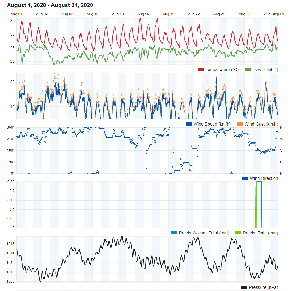
Hotter August 2020

Air Temperature

Highest Maximum 35.8°C 15th
Lowest Maximum 28.7°C 5th
Highest Minimum 26.3°C 1st 
Lowest Minimum 22.6°C 21st


Mean Maximum 31.9°C
Mean Minimum 24.3°C
Mean 28.1°C


Relative Humidity

Highest Relative Humidity 96% 3rd, 4th and 5th
Lowest Relative Humidity 20% 31st


Mean Relative Humidity 72.8%


Atmospheric Pressure

Highest Atmospheric Pressure 1018.0hPa 13th and 21st
Lowest Atmospheric Pressure 1007.8hPa 31st


Mean Atmospheric Pressure 1013.1hPa


Wind

Highest Gust 45.1km/h 6th


Mean Wind Speed 6.5km/h
Mean Gust Speed 12.4km/h
Mean Wind + Gust Speed 9.5km/h
Most Frequent Wind Direction Northwest


Precipitation

Total Rainfall During August 2020 0.0 mm
Total Rainfall Since Last 01/09 406.1 mm


Highest 24 Hour Total 0.0 mm


Rain Days https://southafrica-ed.com/kamagra-in-south-africa/ 0
Thunderstorm Days 0
Hail Days 0


August 2020 Compared to the Climate Means

  Climate Mean August 2020 Anomaly
Mean Maximum Temperature 31.1°C 31.9°C +0.8°C
Mean Minimum Temperature 22.9°C 24.3°C +1.4°C
Mean Temperature 27.0°C 28.1°C +1.1°C
Mean Relative Humidity 73% 72.8% -0.2%
Mean Atmospheric Pressure 1015.4hPa 1013.1hPa -2.3hPa
Mean Wind Speed 13.0 km/h 9.5 km/h -3.5km/h
Most Frequent Wind Direction Northwest Northwest
Total Rainfall 7.9 mm 0.0 mm -7.9 mm
Total Rainfall Since Last 01/09 555.7 mm 406.1 mm -149.6 mm
Total Rain Days 1 0 -1
Total Thunderstorm Days 0 0 0
Total Hail Days 0 0 0


Hotter August 2020

August 2020 was the hottest month of the year. It was a staggering 1.4°C hotter than July, the second hottest month of 2020. The average temperature exceeded the climate norm by 1.1°C. The climate average was exceeded on a total of 25 out of 31 days. The maximum temperature for August was registered at the height of a heat spell which characterised much of the second and third week of August. The mercury on the 15th soared to 35.8°C. Nights offered litle relief throughout. With the exception of just one night (the 21st), the minimum temperature never dipped below the 23°C mark.

Our weather station in Għarb recorded no precipitation in August 2020, as rain clouds kept well away of the Maltese Islands. It is quite common to experience a completely dry August. In fact, six of the past ten years experienced a bone dry August. An interesting observation was the lack of cumulus clouds (locally referred to as the ‘għarixa’). These were only sparsely observed. This implies a lack of cool air aloft, a sure sign of a stable atmosphere.

Overall, the wind was lighter than normal. The wind gusted up to Force 6 on just three days. All three were back-to-back (the 4th, 5th and 6th). The highest wind gust was registered at 45.1 km/h (Force 6), on the 6th. These three days were also the only three days with a maximum temperature below 30°C. This was due to a short-lived area of instability across the central Mediterranean.

End of Month Reports

Cooler Days but Warmer Nights in July 2020

Air Temperature

Highest Maximum 34.6°C 30th
Lowest Maximum 27.4°C 7th
Highest Minimum 25.8°C 31st 
Lowest Minimum 21.1°C 10th


Mean Maximum 30.6°C
Mean Minimum 22.9°C
Mean 26.7°C


Relative Humidity

Highest Relative Humidity 97% Several Days
Lowest Relative Humidity 35% 2nd


Mean Relative Humidity 76.7%


Atmospheric Pressure

Highest Atmospheric Pressure 1020.3hPa 21st
Lowest Atmospheric Pressure 1008.1hPa 6th and 7th 


Mean Atmospheric Pressure 1014.5hPa


Wind

Highest Gust 51.5km/h 4th and 5th 


Mean Wind Speed 8.2km/h
Mean Gust Speed 15.0km/h
Mean Wind + Gust Speed 11.6km/h
Most Frequent Wind Direction Northwest


Precipitation

Total Rainfall During July 2020 0.3 mm
Total Rainfall Since Last 01/09 406.1 mm


Highest 24 Hour Total 0.3 mm 2oth


Rain Days 1
Thunderstorm Days 0
Hail Days 0


Rainfall Events

20/07/2020 0.3 mm Light Rain Shower


July 2020 Compared to the Climate Means

  Climate Mean July 2020 Anomaly
Mean Maximum Temperature 31.2°C 30.6°C -0.6°C
Mean Minimum Temperature 22.0°C 22.9°C +0.9°C
Mean Temperature 26.6°C 26.7°C +0.1°C
Mean Relative Humidity 69% 76.7% +7.7%
Mean Atmospheric Pressure 1015.7hPa 1014.5hPa -1.2hPa
Mean Wind Speed 13.3 km/h 11.6km/h -1.7km/h
Most Frequent Wind Direction Northwest Northwest
Total Rainfall 0.3 mm 0.3 mm 0 mm
Total Rainfall Since Last 01/09 547.8 mm 406.1 mm -141.7 mm
Total Rain Days 0 0 +1
Total Thunderstorm Days 0 0 0
Total Hail Days 0 0 0


Cooler Days but Warmer Nights in July 2020

At 30.6°C, daytime highs were 0.6°C cooler than normal. Conversely, at 22.9°C, nighttime lows were 0.9°C warmer than the norm. This made for an overall difference of only 0.1°C from the climate mean. Up till 23rd July, maximum temperatures exceeded the climatic norm of 31.2°C on only three days. This was due to the presence of an upper level cold pool. This covered the central Mediterranean for a large part of the first two thirds of the month. Apart from keeping temperatures cool, this cold pool was responsible for several days with a breezy Northwest wind. The final nine days, on the other hand, were characterised by a heat spell. July 2020’s hottest temperature was recorded at 34.6°C on the 30th. This was followed by the month’s warmest night. A minimum temperature of 25.8°C was measured just before dawn on the 31st. Dipping into the sea during this heat spell provided little respite. The sea surface temperature shot up to 28°C, a full 3°C above the climate mean, in the final days of July 2020.

July 2020 is known for being the year’s driest month. This time round, it was a tad different, at least for a few localities. A heavy rain shower produced up to 30.5 mm in localised areas. Rain in July is rare, but not unheard of. This was only the third time in recent decades that such heavy rainfall occurred in July. Meanwhile, our weather station in Għarb only recorded a brief shower, with 0.3 mm of rainfall.

Levels of relative humidity were significantly higher than in a typical July. In fact, all but one morning recorded relative humidity greater than 90%. Most mornings were characterised by mist or fog patches and low clouds. The more humid air can be attributed to the warmer than average sea across the central Mediterranean.

End of Month Reports

Completely Dry in June 2020

Air Temperature

Highest Maximum 33.0°C 30th
Lowest Maximum 23.6°C 5th and 6th
Highest Minimum 22.4°C 30th 
Lowest Minimum 17.4°C 1st and 2nd


Mean Maximum 27.0°C
Mean Minimum 19.7°C
Mean 23.4°C


Relative Humidity

Highest Relative Humidity 98% On 7th and 30th 
Lowest Relative Humidity 32% 14th


Mean Relative Humidity 75.7%


Atmospheric Pressure

Highest Atmospheric Pressure 1020.3hPa 25th
Lowest Atmospheric Pressure 1002.7hPa 5th


Mean Atmospheric Pressure 1014.2hPa


Wind

Highest Gust 59.5km/h 5th


Mean Wind Speed 10.4km/h
Mean Gust Speed 19.1km/h
Mean Wind + Gust Speed 14.8km/h
Most Frequent Wind Direction Northwest


Precipitation

Total Rainfall During June 2020 0.0 mm
Total Rainfall Since Last 01/09 405.8 mm


Highest 24 Hour Total 0.0 mm /


Rain Days 0
Thunderstorm Days 0
Hail Days 0


June 2020 Compared to the Climate Means

  Climate Mean June 2020 Anomaly
Mean Maximum Temperature 27.4°C 27.0°C -0.8°C
Mean Minimum Temperature 19.4°C 19.7°C +0.3°C
Mean Temperature 23.6°C 23.4°C -0.2°C
Mean Relative Humidity 71% 75.7% +4.7%
Mean Atmospheric Pressure 1015.8hPa 1014.2hPa -1.6hPa
Mean Wind Speed 15.2 km/h 14.8km/h -0.4km/h
Most Frequent Wind Direction Northwest Northwest
Total Rainfall 3.9 mm 0.0 mm -3.9 mm
Total Rainfall Since Last 01/09 547.5 mm 405.8 mm -141.7 mm
Total Rain Days 1 0 -1
Total Thunderstorm Days 0 0 0
Total Hail Days 0 0 0


Completely Dry in June 2020

Air temperatures varied between the highest maximum of 33.0°C (on the 30th) and the lowest minimum of 17.4°C (on the 1st and 2nd). Averaging at 27.0°C, the mean maximum temperature was some 0.8°C below the average for this time of year. The minimum temperature, on the other hand, was 0.3°C warmer than the expected value. This made for June being an overall fairly typical one with regards to air temperature. No heatwaves were experienced. In fact, temperatures only exceeded the 30°C mark on 4 days.

Atmospheric pressure was slightly weaker than what one would expect in a typical June. The central Mediterranean was affected by zones of instability more often than usual. This is also reflected in the number of days with winds in excess of 39 km/h (Force 6). This wind speed was reached on a total of 9 days in June 2020. The strongest gust was measured at 59.5 km/h from the Northwest on the 5th. That day also accounted for the lowest atmospheric pressure reading for June 2020. Most days last month were characterised by a Northwest wind. A more unstable atmosphere also contributed to an overall higher level of relative humidity.

Despite the greater instability, June 2020 ended up being a completely dry month. It was the third completely dry June in the past 10 years. The closest rain showers and thunderstorms were over Sicily.

End of Month Reports

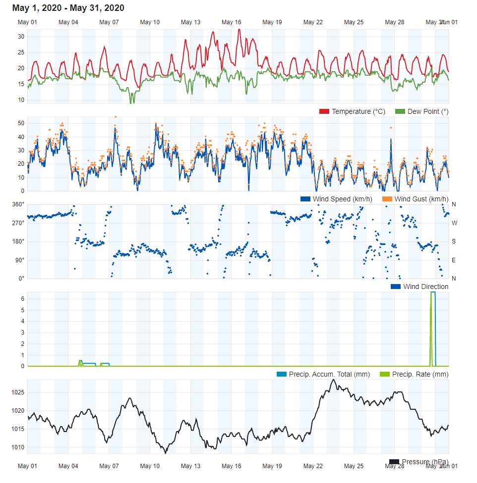
One Heatwave and a Severe Thunderstorm in May 2020

Air Temperature

Highest Maximum 32.3°C 16th
Lowest Maximum 21.3°C 7th
Highest Minimum 20.6°C 16th 
Lowest Minimum 13.4°C 9th


Mean Maximum 24.7°C
Mean Minimum 17.3°C
Mean 21.0°C


Relative Humidity

Highest Relative Humidity 100% On 4th and 5th 
Lowest Relative Humidity 30% 17th


Mean Relative Humidity 76.8%


Atmospheric Pressure

Highest Atmospheric Pressure 1028.5hPa 23rd
Lowest Atmospheric Pressure 1007.5hPa 11th


Mean Atmospheric Pressure 1016.9hPa


Wind

Highest Gust 54.7km/h 7th


Mean Wind Speed 10.8km/h
Mean Gust Speed 32.1km/h
Mean Wind + Gust Speed 21.5km/h
Most Frequent Wind Direction South Southeast


Precipitation

Total Rainfall During April 2020 6.6 mm
Total Rainfall Since Last 01/09 405.8 mm


Highest 24 Hour Total 6.6 mm 30th


Rain Days 2
Thunderstorm Days 1
Hail Days 0


Rainfall Events

27/05/2020 TR mm Severe Thunderstorm in Malta; Drizzle in Għarb
30/05/2020 6.6 mm Rain Shower


May 2020 Compared to the Climate Means
   

  Climate Mean May 2020 Anomaly
Mean Maximum Temperature 23.4°C 24.7°C +1.3°C
Mean Minimum Temperature 15.8°C 17.3°C +1.5°C
Mean Temperature 19.6°C 21.0°C +1.4°C
Mean Relative Humidity 71% 76.8% +5.8%
Mean Atmospheric Pressure 1015.3hPa 1016.9hPa +1.6hPa
Mean Wind Speed 17.0 km/h 21.5km/h +4.5km/h
Most Frequent Wind Direction Northwest South Southeast +157.5°
Total Rainfall 9.9 mm 6.6 mm -3.3 mm
Total Rainfall Since Last 01/09 543.6 mm 405.8 mm -137.8 mm
Total Rain Days 3 2 -1
Total Thunderstorm Days 1 1 0
Total Hail Days 1 0 0


One Heatwave and a Severe Thunderstorm in May 2020

Most days last month were characterized by air temperatures at or slightly above the climate average. The same cannot be said for the stretch of days from the 12th till the 17th, however. Warmer than average temperatures characterized much of May 2020’s second week. Using the national criterion for a heatwave, we may conclude that the Maltese Islands experienced one heatwave during this month. This lasted for three days, from 14/05/2020 till 16/05/2020. The maximum temperature measured during this heatwave was of 32.3°C on the 16th. It was the hottest May day in 14 years. With a monthly mean temperature of 21.0°C, May 2020 was 1.4°C warmer than usual. Both days and nights were substantially warmer.

The most notable event last month was a severe thunderstorm on 27/05/2020. At least two thunderstorms drenched mainland Malta on that day. The second of these, which struck late in the afternoon, was confirmed as having been severe. It produced wind gusts of up to Force 8 (over 62 km/h), hailstones with a diameter of around 2.5 centimetres (the size of a €2 coin) and a confirmed waterspout (dissipated when over the beach) close to Armier. Total rainfall ranged from 6.4 mm (Birżebbuġa) to 41.2 mm (Għargħur). A separate shower occurred over parts of Gozo. The western half of the sister island, which encompasses our weather station in Għarb, remained completely dry. Għarb saw only one day of rain. This was the 30th, when 6.6 mm of rain were measured during an afternoon shower.

This year’s May lived up to the expectation of it being a blustery month, with 10 days in total seeing winds greater than Force 6 (39 km/h) on the Beaufort Scale. Soitherly winds dominated May 2020. In fact, the wind blew from a southerly quadrant on a total of 17 days.

Atmospheric pressure clocked in at an average 1016.9hPa. This is well above average for this time of year.

End of Month Reports

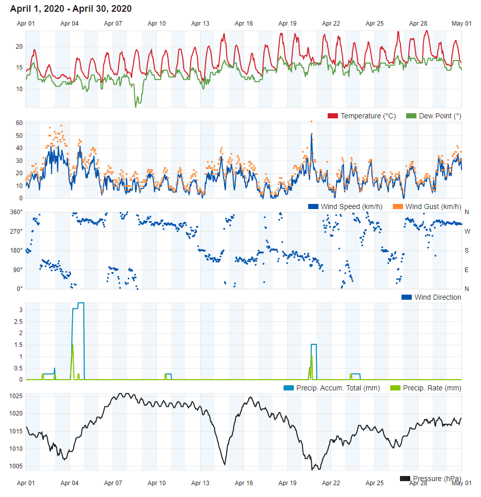
Warmer and Drier April 2020

Air Temperature

Highest Maximum 23.7°C 28th
Lowest Maximum 13.4°C 3rd
Highest Minimum 15.9°C 28th 
Lowest Minimum 11.1°C 13th


Mean Maximum 20.1°C
Mean Minimum 13.7°C
Mean 16.9°C


Relative Humidity

Highest Relative Humidity 100% Several days
Lowest Relative Humidity 42% 13th


Mean Relative Humidity 82.0%


Atmospheric Pressure

Highest Atmospheric Pressure 1026.0hPa 7th
Lowest Atmospheric Pressure 1002.6hPa 20th


Mean Atmospheric Pressure 1016.6hPa


Wind

Highest Gust 61.2km/h 20th


Mean Wind Speed 9.1km/h
Mean Gust Speed 31.3km/h
Mean Wind + Gust Speed 20.2km/h
Most Frequent Wind Direction Northwest


Precipitation

Total Rainfall During April 2020 8.2 mm
Total Rainfall Since Last 01/09 399.2 mm


Highest 24 Hour Total 5.9 mm 4th


Rain Days 4
Thunderstorm Days 0
Hail Days 0


Rainfall Events

02/04/2020 0.5 mm Drizzle
04/04/2020 5.9 mm Isolated Thunderstorms
20/04/2020 1.6 mm Light Rain and Drizzle
29/04/2020 0.2 mm Drizzle


April 2020 Compared to the Climate Means  

  Climate Mean April 2020 Anomaly
Mean Maximum Temperature 19.4°C 20.1°C +0.7°C
Mean Minimum Temperature 12.8°C 13.7°C +0.9°C
Mean Temperature 16.1°C 16.9°C +0.8°C
Mean Relative Humidity 77% 82% +5%
Mean Atmospheric Pressure 1014.3hPa 1016.6hPa +2.3hPa
Mean Wind Speed 18.9 km/h 20.1km/h +1.1km/h
Most Frequent Wind Direction Northwest Northwest
Total Rainfall 20.9 mm 8.2 mm -12.7 mm
Total Rainfall Since Last 01/09 533.7 mm 399.2 mm -134.5 mm
Total Rain Days 5 4 -1
Total Thunderstorm Days 1 0 -1
Total Hail Days 1 0 -1


Warmer and Drier April 2020

Spring made its prescence felt across the Maltese Islands last month https://polska-ed.com/kupic-generic-cialis/. Temperatures warmed up gradually over the course of April. Overall, air temperature averaged at 16.9°C, surpassing the climate norm by 0.8°C. Despite this, last month still recorded the coolest April day in many years. With a maximum temperature of 13.4°C, 3rd April was a full 5°C cooler than a typical April day. The warmest day last month was the 28th, with a 23.7°C high. This was exceptionally warm, especially when compared to the warmest temperatures recorded in April of previous years.

Only 8.2 mm of rain were measured over the course of April 2020. This is less than half of the total amount expected during this month. As is the norm in spring, much of this rain fell with showers which deposited fine desert sand from over the Sahara. 399.2 mm of rain have been recorded at our weather station in Għarb since last September 1st. That is some 130 mm less than in a typical year.

The first four months of the year are the windiest locally. April 2020 conformed with the norm in this aspect. An average wind speed of 20.1 km/h over the past 30 days, meant that winds were in line with the average. The wind exceeded Force 7 on 3 days. April’s highest wind gust of 61.2 km/h from the East Southeast was registered on the 20th. This was due to a deep low pressure system traversing the central Mediterranean.

Atmospheric pressure clocked in at an average 1016.6hPa, above the average for this time of year. This explains the warmer and drier than average conditions experienced in April 2020.

End of Month Reports

March 2020 eases winter’s drought

Air Temperature

Highest Maximum 22.2°C 2nd
Lowest Maximum 13.3°C 30th
Highest Minimum 13.9°C 1st 
Lowest Minimum 8.8°C 26th


Mean Maximum 16.8°C
Mean Minimum 11.6°C
Mean 14.2°C


Relative Humidity

Highest Relative Humidity 100% Several days
Lowest Relative Humidity 40% 2nd


Mean Relative Humidity 84.2%


Atmospheric Pressure

Highest Atmospheric Pressure 1028.7hPa 17th
Lowest Atmospheric Pressure 995.6hPa 25th


Mean Atmospheric Pressure 1015.5hPa


Wind

Highest Gust 72.4km/h 26th


Mean Wind Speed 11.9km/h
Mean Gust Speed 37.9km/h
Mean Wind + Gust Speed 24.9km/h
Most Frequent Wind Direction Northwest


Precipitation

Total Rainfall During March 2020 33.3 mm
Total Rainfall Since Last 01/09 391.7 mm


Highest 24 Hour Total 10.3 mm 10th


Rain Days 10
Thunderstorm Days 1
Hail Days 1


Rainfall Events

04/03/2020 0.5 mm Isolated Light Rain
05/03/2020 1.6 mm Isolated Showers
09/03/2020 1.4 mm Isolated Showers
10/03/2020 10.3 mm Showers
21/03/2020 0.6 mm Isolated Light Rain
24/03/2020 0.2 mm Brief Light Rain/Drizzle
25/03/2020 9.5 mm Showers; Isolated Thunderstorm with Hail
26/03/2020 1.6 mm Isolated Light Rain
27/03/2020 1.5 mm Isolated Light Rain
30/03/2020 6.1 mm Showers; Persistent Drizzle


March 2020 Compared to the Climate Means 

  Climate Mean March 2020 Anomaly
Mean Maximum Temperature 17.0°C 16.8°C -0.2°C
Mean Minimum Temperature 10.9°C 11.6°C +0.7°C
Mean Temperature 14.0°C 14.2°C +0.2°C
Mean Relative Humidity polska-ed.com 79% 84.2% +5.2%
Mean Atmospheric Pressure 1016.1hPa 1015.5hPa -0.6hPa
Mean Wind Speed 18.9 km/h 11.9km/h -7.0km/h
Most Frequent Wind Direction Northwest Northwest
Total Rainfall 39.8 mm 33.3 mm -6.5 mm
Total Rainfall Since Last 01/09 512.8 mm 391.0 mm -121.8 mm
Total Rain Days 7 10 +3
Total Thunderstorm Days 2 1 -1
Total Hail Days 1 1 0


March 2020 eases winter’s drought

With 33.3 mm of rain, March 2020 was wetter than both January 2020 and February 2020 combined. Only 6.4 mm were measured in the previous two months combined. The total of 33.3 mm still means that last month was, albeit by a narrow margin, drier than average. Some localities around the Maltese Islands had a wetter March though. It was down to the spatial variation in heavy rain cells on the 25th and 30th. The 10.3 mm measured on the 10th was the highest 24 hour total since last 11th December  All in all, March 2020 helped ease the drought that has gripped the Maltese Islands since the beginning of December 2019.

A glance at data reveals that the Maltese Islands experienced a typical March temperature-wise. The mean temperature of 14.2°C was only a marginal 0.2°C above the climatic average. Daytime highs averaged 16.8°C, 0.2°C below the norm. Delving deeper, however, will reveal that nighttime lows were on the whole more than half a degree warmer than usual. Values of air temperature varied evenly over the course of March 2020. A notable observation is the lowest maximum temperature of 13.3°C, measured on the 30th. No day was as cold in either January 2020 or February 2020.

March is typically one of the windiest months locally. March 2020 was much calmer, with only one day of gale-force winds. This was the 26th, when the month’s highest wind gust of 72.4 km/h from the Northwest was measured.

Atmospheric pressure clocked in at an average 1015.5hPa, slightly below the average for this time of year. This was a stark contrast to atmospheric pressure readings in January 2020 and February 2020. Both months were characterised by extremely high atmospheric pressure. It was the result of a strong positive North Atlantic Oscillation (NAO). The pattern flipped during March. A strong high pressure developed close to the British Isles. This expanded to cover a large part of central and northern Europe. The high pressure over those regions deviated the storm track south, encouraging low pressure systems to reach the central Mediterranean.

End of Month Reports

February 2020 was the Driest February on Record

Air Temperature

Highest Maximum 18.9°C 1st
Lowest Maximum 13.8°C 6th and 7th
Highest Minimum 14.7°C 4th 
Lowest Minimum 8.1°C 7th


Mean Maximum 16.6°C
Mean Minimum 11.4°C
Mean 14.0°C


Relative Humidity

Highest Relative Humidity 100% Several days
Lowest Relative Humidity 40% 5th


Mean Relative Humidity 82.6%


Atmospheric Pressure

Highest Atmospheric Pressure 1034.7hPa 9th
Lowest Atmospheric Pressure 1009.0hPa 5th


Mean Atmospheric Pressure 1023.2hPa


Wind

Highest Gust 74.0km/h 5th


Mean Wind Speed 13.0km/h
Mean Gust Speed 37.2km/h
Mean Wind + Gust Speed 25.1km/h
Most Frequent Wind Direction Northwest


Precipitation

Total Rainfall During February 2020 0.5 mm
Total Rainfall Since Last 01/09 357.7 mm


Highest 24 Hour Total 0.5 mm 5th


Rain Days 1
Thunderstorm Days 0
Hail Days 1


Rainfall Events

05/02/2020 0.5 mm Light Rain/Hail


February 2020 Compared to the Climate Means 

  Climate Mean February 2020 Anomaly
Mean Maximum Temperature 15.5°C 16.6°C +1.1°C
Mean Minimum Temperature 9.6°C 11.4°C +1.8°C
Mean Temperature 12.6°C 14.0°C +1.4°C
Mean Relative Humidity 78% 82.6% +4.6%
Mean Atmospheric Pressure 1016.6hPa 1023.2hPa +6.6hPa
Mean Wind Speed 19.1 km/h 13.0km/h -6.1km/h
Most Frequent Wind Direction Northwest Northwest
Total Rainfall 61.5 mm 0.5 mm -61.0 mm
Total Rainfall Since Last 01/09 473.0 mm 357.7 mm -115.3 mm
Total Rain Days 10 1 -9
Total Thunderstorm Days 3 0 -3
Total Hail Days 1 1 0


February 2020 was the Driest February on Record

With a mere 0.5 mm of rain – registered in a brief isolated light rain and/or hail shower on the 5th – February 2020 has become the driest on record. It broke the record set in 2016. According to climate data, February is normally one of the year’s wettest months. The amount of rain measured over the course of this year’s exceptionally dry February is more comparable to the values usually registered during the summer months. In fact, past data reveals that February 2020 was drier than July 2019.

With regards to air temperatures, the Maltese Islands experienced a very mild February. The mean maximum of 16.6°C was just over a degree above the average. The mean minimum of 11.4°C exceeded the norm by almost two degrees. The first ten days of the month registered all of February 2020’s extremes. With an 18.9°C high, the first day of the month was also the warmest. A few days later, on the 7th, our weather station measured February 2020’s lowest temperature of 8.1°C. From 10th February onward, under persistent anticyclonic conditions, the temperature stabilised.

February is typically the windiest month, locally. February 2020 was much calmer, with only one gale. The highest wind gust of 74.0 km/h, from the Northwest, was registered on the 5th. The wind did not exceed the 50.0 km/h mark for the rest of the month. Calm nights were a common occurrence.

Atmospheric pressure clocked in at an average 1023.2hPa, a full 6.6hPa greater than the norm for this time of year. The maximum atmospheric pressure reading of 1034.7hPa came very close to breaking the all time record for our weather station. A strong positive North Atlantic Oscillation (NAO) prevailed throughout the month. A stronger than usual Azores High in combination with a deeper than normal Icelandic Low was reflected by data gathered at our weather station in Għarb. Anticyclones characterised our weather in February 2020. All low pressure systems, with the exception of one, originating over the Atlantic were forced northwards. This meteorological situation meant that the Maltese Islands experienced complete dryness and milder temperatures in February 2020.

End of Month Reports

January 2020 was one of the Driest on Record

Air Temperature

Highest Maximum 17.9°C 26th
Lowest Maximum 12.4°C 6th
Highest Minimum 13.5°C 26th 
Lowest Minimum 7.3°C 5th


Mean Maximum 15.7°C
Mean Minimum 11.1°C
Mean 13.4°C


Relative Humidity

Highest Relative Humidity 100% Several days
Lowest Relative Humidity 49% 5th


Mean Relative Humidity 87.9%


Atmospheric Pressure

Highest Atmospheric Pressure 1034.5hPa 22nd
Lowest Atmospheric Pressure 1019.7hPa 26th


Mean Atmospheric Pressure 1025.5hPa


Wind

Highest Gust 56.3km/h 5th


Mean Wind Speed 9.0km/h
Mean Gust Speed 31.6km/h
Mean Wind + Gust Speed 20.3km/h
Most Frequent Wind Direction Northwest


Precipitation

Total Rainfall During January 2020 8.9 mm
Total Rainfall Since Last 01/09 357.2 mm


Highest 24 Hour Total 5.9 mm 13th


Rain Days 4
Thunderstorm Days 0
Hail Days 0


Rainfall Events

12/01/2020 0.5 mm Drizzle
13/01/2020 5.9 mm Isolated Showers
14/01/2020 1.5 mm Isolated Light Rain
21/01/2020 1.0 mm Isolated Light Rain


January 2020 Compared to the Climate Means 

  Climate Mean January 2020 Anomaly
Mean Maximum Temperature 15.4°C 15.7°C +0.3°C
Mean Minimum Temperature 9.9°C 11.1°C +1.2°C
Mean Temperature 12.7°C 13.4°C +0.7°C
Mean Relative Humidity 79% 87.9% +8.9%
Mean Atmospheric Pressure 1018.2hPa 1025.5hPa +7.3hPa
Mean Wind Speed 18.9 km/h 20.3km/h +1.4km/h
Most Frequent Wind Direction Northwest Northwest
Total Rainfall 85.4 mm 8.9 mm -76.5 mm
Total Rainfall Since Last 01/09 411.5 mm 357.2 mm -54.3 mm
Total Rain Days 13 4 -9
Total Thunderstorm Days 3 0 -3
Total Hail Days 1 0 -1


January 2020 was one of the Driest on Record

The month of January was extremely drier than average. In fact, it came close to breaking a decades old record for the driest January ever. The measly 8.9 mm measured over the course of this month was just 10% of the total we normally receive in a typical January. In terms of dry weather, January 2020 continued the trend set at the beginning of December 2019. Only 4 days of rain were recorded. With the exception of a brief hailstorm in Mellieħa, no thunder or hail was observed across the Maltese Islands this month. All rain this January came in brief isolated showers, a weather pattern we often experience in late spring.

With regards to air temperatures, the Maltese Islands experienced a mild January. Daytime highs, at a mean of 15.7°C, were only slightly above the average. The average nighttime low of 11.1°C, however, was a solid 1.2°C greater than the mean for this time of year. A brief cold spell towards the start of the month registered January 2020’s coldest minimum temperature of 7.3°C. No other cold spell was observed over the course of the month. The rest of January 2020, especially its second half, was marked by warmer than average temperatures.

January is typically a windy month, locally. January 2020 was overally quite breezy, with winds reaching the Force 4/5 mark on a number of days. However, it was marked by the complete abscence of gale-force winds. The highest wind gust last month was of only 56.3 km/h, from the North Northwest.

A very strong positive North Atlantic Oscillation (NAO) was present throughout the month. A stronger than usual Azores High in combination with a deeper than normal Icelandic Low left its impact on the data gathered by our weather station in Għarb. Anticyclones characterised our weather in January 2020. Low pressure systems coming in from the Atlantic were forced northwards. This meteorological situation meant that the Maltese Islands experienced some very dry weather and milder temperatures throughout the month of January 2020. This was confirmed by atmospheric pressure gathered at our weather station in Għarb. The mean value of 1025.5hPa exceeded the climate average significantly. The maximum atmospheric pressure reading of 1034.5hPa came very close to breaking the all time record.

End of Month Reports

Warmer and Drier December 2019

Air Temperature

Highest Maximum 22.5°C 3rd
Lowest Maximum 12.0°C 29th
Highest Minimum 16.4°C 3rd and 18th 
Lowest Minimum 6.5°C 30th


Mean Maximum 17.5°C
Mean Minimum 13.5°C
Mean 15.5°C


Relative Humidity

Highest Relative Humidity 100% Several days
Lowest Relative Humidity 54% 28th


Mean Relative Humidity 83.5%


Atmospheric Pressure

Highest Atmospheric Pressure 1028.9hPa 31st
Lowest Atmospheric Pressure 1000.8hPa 14th


Mean Atmospheric Pressure 1017.7hPa


Wind

Highest Gust 82.1km/h 14th


Mean Wind Speed 14.0km/h
Mean Gust Speed 45.6km/h
Mean Wind + Gust Speed 29.8km/h
Most Frequent Wind Direction Northwest


Precipitation

Total Rainfall During December 2019 34.6 mm https://southafrica-ed.com/kamagra-in-south-africa/
Total Rainfall Since Last 01/09 348.3 mm


Highest 24 Hour Total 11.0 mm 10th


Rain Days 10
Thunderstorm Days 3
Hail Days 4


Rainfall Events

09/12/2019 0.2 mm Drizzle
10/12/2019 9.2 mm Rain/Hail Showers
11/12/2019 0.3 mm Drizzle
12/12/2019 11.0 mm Intermittent Rain/Hail
13/12/2019 3.5 mm Isolated Showers
14/12/2019 0.8 mm Drizzle
22/12/2019 1.0 mm Drizzle
23/12/2019 0.3 mm Drizzle
30/12/2019 2.8 mm Rain/Hail Showers
31/12/2019 5.5 mm Rain/Hail Showers


December 2019 Compared to the Climate Means 

  Climate Mean December 2019 Anomaly
Mean Maximum Temperature 17.1°C 20.7°C +0.4°C
Mean Minimum Temperature 11.8°C 15.6°C +1.7°C
Mean Temperature 14.5°C 18.2°C +1.0°C
Mean Relative Humidity 79% 71.7% +4.5%
Mean Atmospheric Pressure 1017.3hPa 1012.3hPa +0.4hPa
Mean Wind Speed 18.2 km/h 10.0km/h -4.2km/h
Most Frequent Wind Direction Northwest South
Total Rainfall 109.7 mm 129.3 mm -75.1 mm
Total Rainfall Since Last 01/09 342.1 mm 313.7 mm +6.2 mm
Total Rain Days 14 10 -4
Total Thunderstorm Days 4 3 -1
Total Hail Days 1 4 +3


Warmer and Drier December 2019

Temperatures throughout the last month of 2019 followed the trend set in previous months. Daytime highs exceeded the norm by just less than half a degree. Nighttime lows, on the other hand, were almost a solid 2˚C warmer than average. December 2019 started on a very warm note, with maximum temperatures of around 20˚C throughout the first week. Nighttime lows never dipped below the 16˚C mark for the duration of the first week. A few days with cooler than average temperature values followed. This didn’t last long, however, as warm conditions returned to the Maltese Islands by mid-December. These prevailed till after Christmas, when the first cold snap of winter gripped the central Mediterranean. It was at this time, that the coldest day and night were measured, with temperatures of 12.0˚C and 6.5˚C respectively.

In a stark contrast to the previous autumnal months, December 2019 was very dry. The 34.6 mm accumulated during the month were a full 75 mm short of the climate average. A typical December is the wettest month of the year. This was the result of anticyclonic conditions that prevailed over the central and eastern Mediterranean. These acted as a barrier, deviating the majority of storm systems to the north. The 10 days of rain and 3 days of thunder observed last month less than the average for this time of year. The 4 days of hail exceeded the climate average, however.

Averaging at 14.0 km/h, the wind speed was weaker than the norm. Weaker winds have been a dominant feature of autumn so far. The month’s windiest day was the 14th, when a gust of 82.1 km/h (Force 9) blowing from a Northwest direction was recorded.

Atmospheric pressure conformed with the norm.

Last month’s highlight was a severe Mistral on the 14th. A depression (980hPa) formed over the Gulf of Genoa, and migrated across Italy and into central/southern Adriatic Sea. Simultaneously, a ridge of high pressure developed to its east, over France. The pressure difference generated a severe gale from the Northwest across the central Mediterranean. The depression was derived from one which had produced a windstorm across the British Isles and northwest Europe some days before. This was only the second gale in an otherwise unusually calm autumn. The bulk of last month’s precipitation was produced by this system. The severe gale-force winds and heavy rain from the system caused disruption and some light damage.