Cooler and Wetter in May 2019
Air Temperature
| Highest Maximum | 24°C | 11th, 24th, 25th and 29th |
| Lowest Maximum | 18°C | 6th, 7th and 16th |
| Highest Minimum | 17°C | 26th, 28th and 29th |
| Lowest Minimum | 12°C | 3rd, 8th and 17th |
| Mean Maximum | 21.0°C |
| Mean Minimum | 14.0°C |
| Mean | 17.5°C |
Relative Humidity
| Highest Relative Humidity | 73% | 2nd and 3rd |
| Lowest Relative Humidity | 29% | 22nd |
| Mean Relative Humidity | 61.0% |
Atmospheric Pressure
| Highest Atmospheric Pressure | 1022.0hPa | 30th |
| Lowest Atmospheric Pressure | 1000.0hPa | 4th |
| Mean Atmospheric Pressure | 1014.0hPa |
Wind
| Highest Gust | 68km/h | 6th |
| Mean Wind Speed | 12km/h |
| Mean Gust Speed | 30km/h |
| Mean Wind + Gust Speed | 21.5km/h |
| Most Frequent Wind Direction | Northwest |
Precipitation
| Total Rainfall During May 2019 | 21.1 mm |
| Total Rainfall Since Last 01/09 | 503.7 mm |
| Highest 24 Hour Total | 7.8 mm | 3rd |
| Rain Days | 8 |
| Thunderstorm Days | 4 |
| Hail Days | 0 |
Rainfall Events
| 03/05/2019 | 7.8 mm | Showers |
| 04/05/2019 | 0.5 mm | Thunderstorm |
| 12/05/2019 | 2.5 mm | Thunderstorm |
| 13/05/2019 | 0.3 mm | Light Rain |
| 14/05/2019 | 2.3 mm | Light Rain |
| 16/05/2019 | 5.6 mm | Thunderstorm |
| 26/05/2019 | 1.8 mm | Thunderstorm |
| 30/05/2019 | 0.3 mm | Light Rain |
May 2019 Compared to the Climate Means
| Climate Mean | May 2019 | Anomaly | |
| Mean Maximum Temperature | 23.9°C | 21.0°C | -2.9°C |
| Mean Minimum Temperature | 15.7°C | 14.0°C | -1.7°C |
| Mean Temperature | 19.8°C | 17.5°C | -2.3°C |
| Mean Relative Humidity | 74% | 61% | -13% |
| Mean Atmospheric Pressure | 1015.3hPa | 1014.0hPa | +1.3hPa |
| Mean Wind Speed | 17.0 km/h | 21.5km/h | +4.5km/h |
| Most Frequent Wind Direction | Northwest | Northwest | Nil |
| Total Rainfall | 10.6 mm | 21.1 mm | +10.5 mm |
| Total Rainfall Since Last 01/09 | 572.3 mm | 503.7 mm | -68.6 mm |
| Total Rain Days | 3 | 5 | +2 |
| Total Thunderstorm Days | 1 | 2 | +1 |
| Total Hail Days | 0 | 0 | 0 |
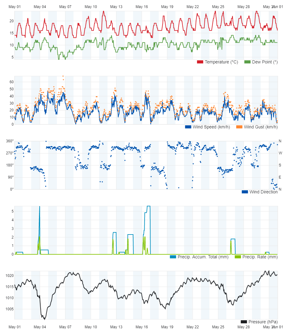
Cooler and Wetter in May 2019
May 2019 was rather cool, as below-average temperatures were recorded throughout. The mean maximum temperature of 23.9°C was exceeded on only 4 days out of 31 days. Overall, the air temperature was 2.3°C colder than the norm. Once again, the biggest margin from the mean was registered by the daytime highs. May 2019 was infact one of the coldest ever. Unseasonal anticyclones over Scandinavia persisted throughout the month. This deflected bad weather towards the Mediterranean. This bad weather brought with it frequent blasts of cold air from the north, allowing temperatures to remain colder than average throughout.
Total rainfall measured at our weather station in Għarb, at 21.1 mm was above the mean for this time of year. The number of days with rain and thunderstorms, at 8 and 4 respectively, were also greater than the norm. This observation is also the result of prevailing anticyclones over Scandinavia, deviating bad weather to the south.
A number of windy days dotted May. Winds were significantly stronger than the average for May. The wind reached Force 6 or higher on 6 days. This was the consequence of air moving from high pressure over Scandinavia towards successive low pressure systems traversing the Mediterranean. The prevailing wind direction was the Northwest. The strongest wind gust was of 68 km/h, registered on the 6th.