September 2018 to August 2019 Rainfall Report
Precipitation Totals
| Total Rainfall in September 2018 | 5.0 mm |
| Total Rainfall in October 2018 | 217.8 mm |
| Total Rainfall in November 2018 | 54.5 mm |
| Total Rainfall in December 2018 | 17.0 mm |
| Total Rainfall in January 2019 | 64.9 mm |
| Total Rainfall in February 2019 | 39.1 mm |
| Total Rainfall in March 2019 | 56.8 mm |
| Total Rainfall in April 2019 | 27.5 mm |
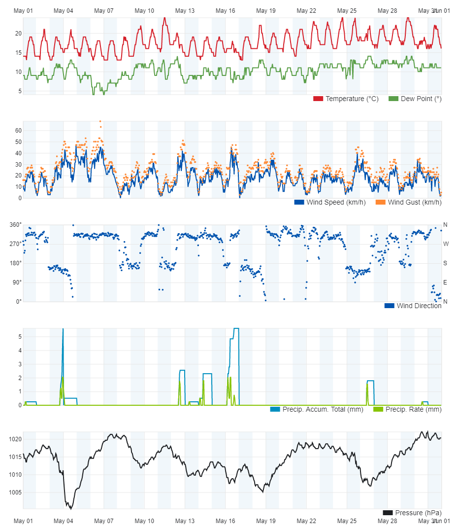
| Total Rainfall in May 2019 | 21.1 mm |
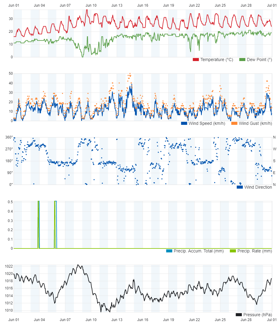
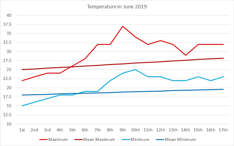
| Total Rainfall in June 2019 | 0.0 mm |
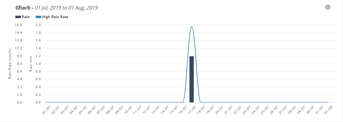
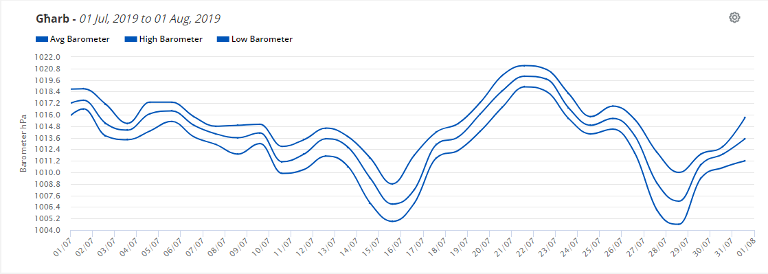
| Total Rainfall in July 2019 | 1.3 mm |
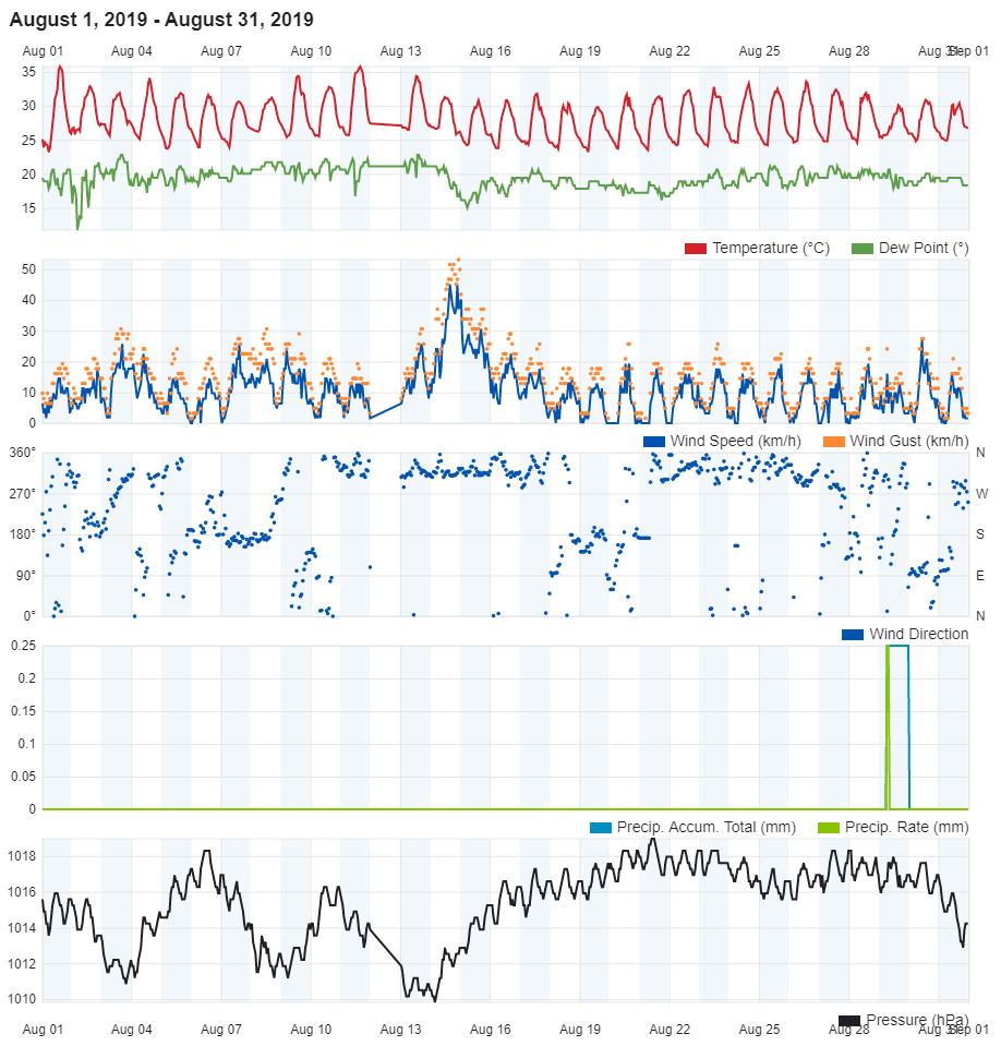
| Total Rainfall in August 2019 | 0.2 mm |
| Total Rainfall from 1st September 2018 till 31st August 2019 | 505.2 mm |
| Highest 24 Hour Total | 43.8 mm | 18th October 2018 |
| Rain Days | 90 days |
| Thunderstorm Days | 24 days |
| Hail Days | 12 days |
2018/2019 Precipitation Compared to the Climate Means
| Climate Mean | 2018/2019 | Anomaly | |
| Total Rainfall in September 2018 | 55.5 mm | 5.0 mm | -50.5 mm |
| Total Rainfall in October 2018 | 83.3 mm | 217.8 mm | +134.5 mm |
| Total Rainfall in November 2018 | 93.6 mm | 54.5 mm | -39.1 mm |
| Total Rainfall in December 2018 | 109.7 mm | 17.0 mm | -92.7 mm |
| Total Rainfall in January 2019 | 94.1 mm | 64.9 mm | -29.2 mm |
| Total Rainfall in February 2019 | 61.6 mm | 39.1 mm | -22.5 mm |
| Total Rainfall in March 2019 | 40.7 mm | 56.8 mm | +16.1 mm |
| Total Rainfall in April 2019 | 23.2 mm | 27.5 mm | -+4.3 mm |
| Total Rainfall in May 2019 | 10.6 mm | 21.1 mm | +10.5 mm |
| Total Rainfall in June 2019 | 4.4 mm | 0.0 mm | -4.4 mm |
| Total Rainfall in July 2019 | 0.3 mm | 1.3 mm | +1.0 mm |
| Total Rainfall in August 2019 | 8.6 mm | 0.2 mm | -8.4 mm |
| Total Rainfall Since Last 01/09 | 585.6 mm | 505.2 mm | -80.4 mm |
| Total Rain Days | 84 | 90 | +6 days |
| Total Thunderstorm Days | 26 | 24 | -2 days |
| Total Hail Days | 8 | 12 | +4 days |
Rainfall Events
| Date | Rainfall | Description |
| 14/09/2018 | 0.8 mm | Light Rain Shower |
| 20/09/2018 | 0.5 mm | Light Thunderstorm |
| 21/09/2018 | 0.8 mm | Light Rain Shower |
| 25/09/2018 | 1.5 mm | Shower |
| 27/09/2018 | 1.4 mm | Shower |
| 02/10/2018 | 16.2 mm | Thunderstorm; Steady Rain |
| 03/10/2018 | 3.0 mm | Shower |
| 04/10/2018 | 30.2 mm | Thunderstorm |
| 05/10/2018 | 0.5 mm | Light Rain Shower |
| 08/10/2018 | 6.8 mm | Thunderstorm |
| 11/10/2018 | 1.6 mm | Light Rain Shower |
| 12/10/2018 | 42.7 mm | Downpour; Thunderstorm |
| 13/10/2018 | 16.0 mm | Downpour |
| 14/10/2018 | 17.4 mm | Showers; Light Rain; Thunderstorm |
| 18/10/2018 | 43.8 mm | Thunderstorm |
| 22/10/2018 | 1.2 mm | Light Rain |
| 23/10/2018 | 15.1 mm | Thunderstorm |
| 29/10/2018 | 0.3 mm | Light Rain Shower |
| 31/10/2018 | 23.0 mm | Steady Rain |
| 01/11/2018 | 7.8 mm | Isolated Showers |
| 02/11/2018 | 3.7 mm | Isolated Showers |
| 10/11/2018 | 18.5 mm | Thunderstorms |
| 11/11/2018 | 3.6 mm | Light Rain |
| 15/11/2018 | 3.4 mm | Light Rain |
| 16/11/2018 | 0.3 mm | Light Rain Shower |
| 17/11/2018 | 5.6 mm | Isolated Showers |
| 18/11/2018 | 1.5 mm | Light Rain Shower |
| 20/11/2018 | 0.3 mm | Light Rain Shower |
| 25/11/2018 | 0.8 mm | Drizzle |
| 26/11/2018 | 0.3 mm | Drizzle |
| 28/11/2018 | 7.7 mm | Isolated Showers |
| 29/11/2018 | 1.3 mm | Light Rain Shower |
| 01/12/2018 | 2.2 mm | Thunderstorm |
| 02/12/2018 | 4.2 mm | Shower |
| 04/12/2018 | 0.3 mm | Drizzle |
| 07/12/2018 | 6.7 mm | Thunderstorm; Shower |
| 08/12/2018 | 0.3 mm | Drizzle |
| 15/12/2018 | 1.4 mm | Thunderstorm |
| 18/12/2018 | 1.3 mm | Light Rain |
| 21/12/2018 | 0.3 mm | Drizzle |
| 24/12/2018 | 0.3 mm | Drizzle |
| 03/01/2019 | 1.3 mm | Light Rain/Hail |
| 06/01/2019 | 2.5 mm | Light Rain/Hail |
| 09/01/2019 | 12.1 mm | Showers |
| 10/01/2019 | 1.0 mm | Light Rain |
| 11/01/2019 | 2.0 mm | Light Rain |
| 12/01/2019 | 0.3 mm | Drizzle |
| 13/01/2019 | 2.0 mm | Showers |
| 14/01/2019 | 7.9 mm | Showers |
| 17/01/2019 | 2.4 mm | Showers |
| 19/01/2019 | 3.6 mm | Showers |
| 20/01/2019 | 6.6 mm | Thundery Rain/Hail Showers |
| 22/01/2019 | 2.8 mm | Showers |
| 23/01/2019 | 0.8 mm | Light Rain |
| 24/01/2019 | 8.4 mm | Rain/Hail Showers |
| 25/01/2019 | 6.4 mm | Rain/Hail Showers |
| 26/01/2019 | 1.7 mm | Shower |
| 27/01/2019 | 0.3 mm | Drizzle |
| 29/01/2019 | 2.3 mm | Thundery Rain/Hail Showers |
| 30/01/2019 | 0.5 mm | Drizzle |
| 03/02/2019 | 3.2 mm | Thundery Rain/Hail Showers |
| 04/02/2019 | 10.2 mm | Showers; Steady Rain |
| 05/02/2019 | 11.6 mm | Thundery Rain/Hail Showers; Steady Rain |
| 07/02/2019 | 0.6 mm | Shower |
| 09/02/2019 | 0.9 mm | Shower |
| 16/02/2019 | 0.8 mm | Shower |
| 23/02/2019 | 6.9 mm | Rain/Hail Showers |
| 24/02/2019 | 2.8 mm | Rain/Hail Showers |
| 28/02/2019 | 3.0 mm | Shower |
| 02/03/2019 | 0.5 mm | Isolated Shower |
| 06/03/2019 | 0.5 mm | Heavy Dewfall |
| 10/03/2019 | 0.3 mm | Heavy Dewfall |
| 12/03/2019 | 0.3 mm | Light Rain Shower |
| 15/03/2019 | 2.0 mm | Light Rain |
| 18/03/2019 | 0.3 mm | Heavy Dewfall |
| 21/03/2019 | 27.4 mm | Thunderstorm |
| 22/03/2019 | 2.5 mm | Light Rain |
| 24/03/2019 | 0.3 mm | Heavy Dewfall |
| 27/03/2019 | 22.7 mm | Thunderstorm |
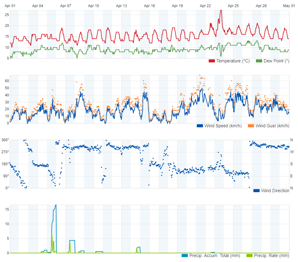
| 04/04/2019 | 1.8 mm | Light Rain |
| 05/04/2019 | 19.1 mm | Thunderstorm |
| 07/04/2019 | 4.3 mm | Isolated Showers |
| 14/04/2019 | 2.0 mm | Isolated Showers |
| 22/04/2019 | 0.3 mm | Light Thunderstorm |
| 03/05/2019 | 7.8 mm | Showers |
| 04/05/2019 | 0.5 mm | Light Thunderstorm |
| 12/05/2019 | 2.5 mm | Light Thunderstorm |
| 13/05/2019 | 0.3 mm | Drizzle |
| 14/05/2019 | 2.3 mm | Light Rain |
| 16/05/2019 | 5.6 mm | Thunderstorm |
| 26/05/2019 | 1.8 mm | Light Thunderstorm |
| 30/05/2019 | 0.3 mm | Light Rain |
| 16/07/2019 | 1.3 mm | Shower |
| 29/08/2019 | 0.2 mm | Light Rain |