Reports

End of Month Reports

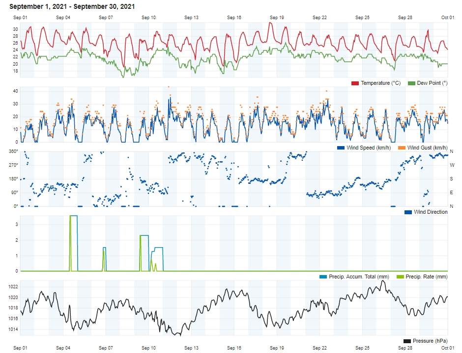
Warmer and Drier September 2021

Air Temperature

Highest Maximum 31.9°C 18th
Lowest Maximum 27.1°C 9th
Highest Minimum 26.0°C 18th 
Lowest Minimum 18.5°C 8th


Mean Maximum 28.9°C
Mean Minimum 22.8°C
Mean 25.9°C


Relative Humidity

Lowest Relative Humidity 47% 15th


Mean Relative Humidity 77.7%


Atmospheric Pressure

Highest Atmospheric Pressure 1023.2hPa 26th
Lowest Atmospheric Pressure 1012.5hPa 12th


Mean Atmospheric Pressure 1017.8hPa


Wind

Highest Gust 43.5km/h 11th


Mean Wind Speed 5.4km/h
Mean Gust Speed 13.3km/h
Mean Wind + Gust Speed 9.3km/h spójrz tutaj
Most Frequent Wind Direction North Northwest


Precipitation

Total Rainfall During September 2021 9.6 mm
Total Rainfall Since Last 01/09 9.6 mm


Highest 24 Hour Total 3.6 mm 4th


Rain Days 5 days
Thunderstorm Days 4 days
Hail Days 0 days


Rainfall Events

04/09/2021 3.6 mm Thunderstorm
06/09/2021 1.5 mm Isolated Thunderstorm
09/09/2021 2.6 mm Isolated Shower; Distant Thunder
10/09/2021 1.5 mm Isolated Shower; Distant Thunder
11/09/2021 0.4 mm Isolated Shower


September 2021 Compared to the Climate Means

  Climate Mean September 2021 Anomaly
Mean Maximum Temperature 28.3°C 28.9°C +0.6°C
Mean Minimum Temperature 20.8°C 22.8°C +2.0°C
Mean Temperature 24.6°C 25.9°C +1.3°C
Mean Relative Humidity 77% 77.7% +0.7%
Mean Atmospheric Pressure 1017.4hPa 1017.8hPa +0.4hPa
Mean Wind Speed 13.7 km/h 9.3 km/h -4.4km/h
Total Rainfall 55.5 mm 9.6 mm -45.9 mm
Total Rainfall Since Last 01/09 55.5 mm 9.6 mm -45.9 mm
Total Rain Days 4 days 5 days +1 day
Total Thunderstorm Days 3 days 4 days +1 day
Total Hail Days 1 day 0 days -1 day


Warmer and Drier in September 2021

Overall, October 2021 turned out to be significantly warmer than the climate norm. At 25.9°C, temperatures were 1.3°C warmer than the mean. Temperatures were above average on 19 days. This may be attributed to the central Mediterranean being covered by a persistent north African high pressure system. This fanned hot air from the Sahara Desert towards our region, maintaining air temperatures at an elevated level. The hottest day last month was on the 18th, when the mercury spiked to 31.9°C.

September 2021 was also drier than average. The 9.6 mm of rain measured last month all fell in the first week. This accounted for far less than a quarter of the climate mean. This was the result of anticyclonic conditions that prevailed over the central Mediterranean for a large part of the month. These acted as a barrier, which prevented low pressure systems from reaching the central Mediterranean.

The more stable meteorological conditions also meant weaker winds.


Rainfall Totals around the Maltese Islands in September 2021 (and since last September 1st):

Għarb – 9.6 mm (9.6 mm)

Marsalforn – 15.2 mm (15.2 mm)

Victoria – 18.4 mm (18.4 mm)

Xewkija – 14.8 mm (14.8 mm)

Nadur – 12.9 mm (12.9 mm)

Mellieħa – 16.8 mm (16.8 mm)

Buġibba – 34.3 (34.3 mm)

Naxxar – 34.3 mm (34.3 mm)

Dingli – 46.2 mm (46.2 mm)

Mġarr – 25.9 mm (25.9 mm)

Mosta – 25.0 mm (25.0 mm)

Msida – 22.8 mm (22.8 mm)

Sliema – 25.4 mm (25.4 mm)

Valletta – 21.1mm (21.1 mm)

Imqabba – 13.3 mm (13.3 mm)

Żabbar – 12.5 mm (12.5 mm)

Birżebbuġa – 12.1 mm (12.1 mm)

NATIONAL MEAN – 21.2 mm (21.2 mm)

End of Month Reports

October 2021 One of the Wettest Ever

Air Temperature

Highest Maximum 27.6°C 4th and 5th
Lowest Maximum 18.4°C 29th
Highest Minimum 21.4°C 1st 
Lowest Minimum 13.9°C 21st


Mean Maximum 23.5°C
Mean Minimum 17.7°C
Mean 20.6°C


Relative Humidity

Lowest Relative Humidity 48% 15th


Mean Relative Humidity 78.0%


Atmospheric Pressure

Highest Atmospheric Pressure 1029.6hPa 20th
Lowest Atmospheric Pressure 1008.0hPa 14th


Mean Atmospheric Pressure 1017.3hPa


Wind

Highest Gust 49.9km/h 16th


Mean Wind Speed 7.2km/h
Mean Gust Speed 16.8km/h
Mean Wind + Gust Speed 11.6km/h
Most Frequent Wind Direction South Southeast


Precipitation

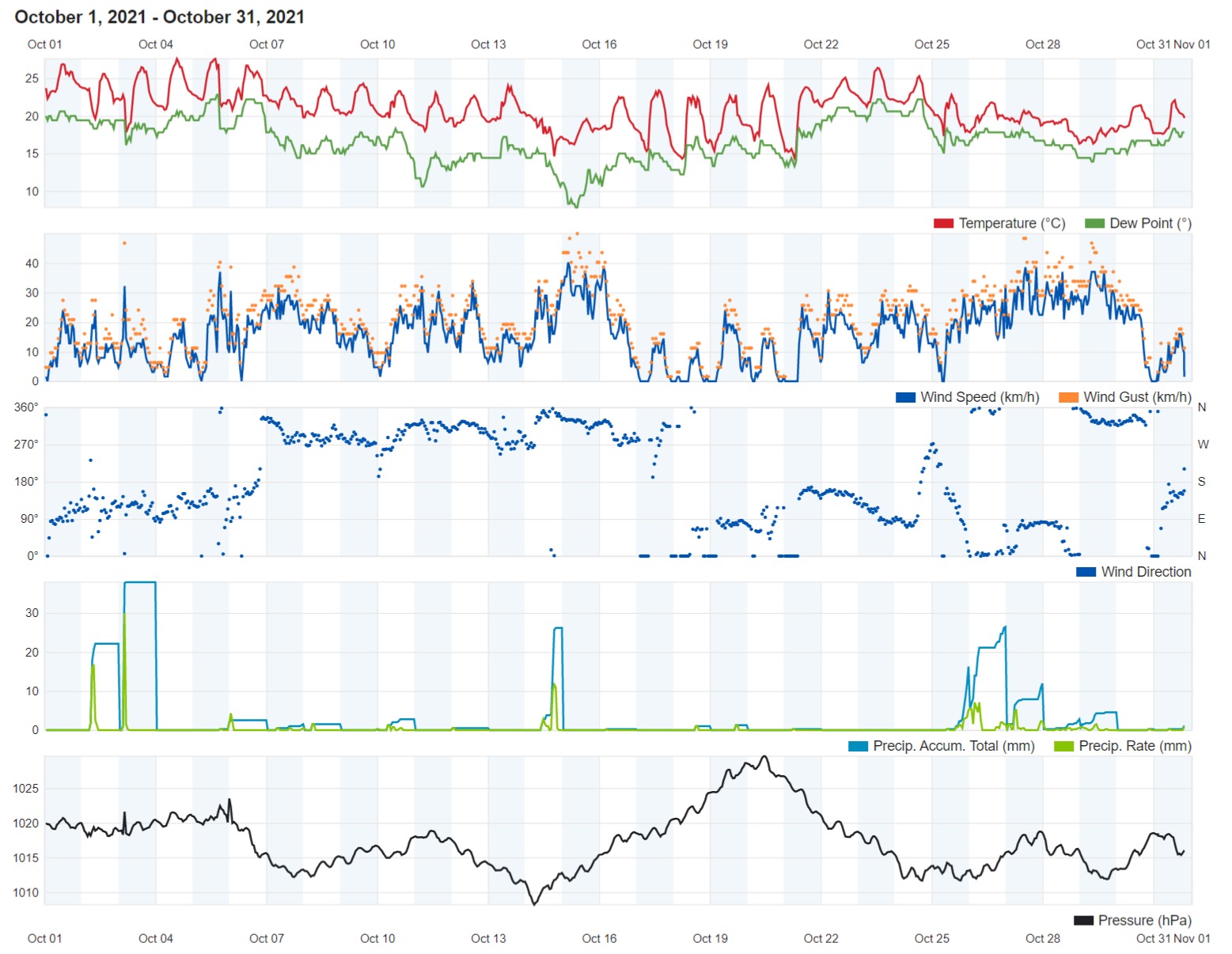
Total Rainfall During October 2021 241.0 mm
Total Rainfall Since Last 01/09 250.6 mm


Highest 24 Hour Total 69.5 mm 3rd


Rain Days 20 days
Thunderstorm Days 10 days
Hail Days 2 days


Rainfall Events

02/10/2021 32.1 mm Thunderstorm; Hail
03/10/2021 69.5 mm Thunderstorm; Hail
05/10/2021 2.4 mm P.M. Isolated Thunderstorm
06/10/2021 3.0 mm A.M. Isolated Thunderstorm
07/10/2021 1.2 mm Isolated Showers
08/10/2021 2.1 mm Isolated Showers
09/10/2021 0.3 mm Isolated Showers
10/10/2021 3.7 mm Isolated Showers; Distant Thunder
12/10/2021 0.4 mm Isolated Showers
14/10/2021 34.5 mm Steady Rain; Thunder
15/10/2021 0.5 mm Isolated Showers
16/10/2021 0.2 mm Light Rain
18/10/2021 1.0 mm Isolated Showers; Distant Thunder
25/10/2021 24.1 mm P.M. Steady Rain; Thunder
26/10/2021 39.7 mm A.M. Steady Rain; Thunder; P.M. Showers
27/10/2021 11.9 mm Showers
28/10/2021 2.8 mm Showers
29/10/2021 4.6 mm Light Rain
30/10/2021 0.3 mm Light Rain
31/10/2021 6.7 mm Light Rain; P.M. Steady Rain


October 2021 Compared to the Climate Means

  Climate Mean October 2021 Anomaly
Mean Maximum Temperature 24.8°C 23.5°C -1.3°C
Mean Minimum Temperature 17.9°C 17.7°C -0.2°C
Mean Temperature 21.4°C 20.6°C -0.8°C
Mean Relative Humidity 78% 78.0% /
Mean Atmospheric Pressure 1017.6hPa 1017.3hPa -0.3hPa
Mean Wind Speed 14.1 km/h 11.6 km/h -2.5km/h
Total Rainfall 83.3 mm 241.0 mm +157.7 mm
Total Rainfall Since Last 01/09 138.8 mm 250.6 mm +111.8 mm
Total Rain Days 10 days 20 days +10 days
Total Thunderstorm Days 5 days 10 days +5 days
Total Hail Days 1 day 2 days + 1 day


October 2021 One of the Wettest Ever

October 2021 turned out to be noticeably cooler than average. With a mean temperature of 20.6°C, last month was a solid 0.8°C cooler than the climate norm. Last month started off on a relatively warm note. This was short-lived, however. Successive pockets of cooler air from over Europe, coupled with the cooling effect of rain on a staggering 20 days, ensured a pattern of consistently cooler than average temperatures. A 13.9°C low, the coldest for October 2021, was registered on the 21st. This was measured at around dawn, after a night of cooling under anticyclonic conditions. The very warm days at the start of the month were brought about by southerly winds which fanned hot air from north Africa towards the central Mediterranean. Last months warmest temperature of 27.6°C was measured on two days, the 4th and 5th.

The 241.0 mm of rain measured last month was almost three times more than the 83.3 mm expected in a typical October. This made October 2021 the third wettest October since record keeping began a century ago. Rain fell on 20 days last month, with rainfall events having been evenly distributed, bar for a brief dry spell in the third week of the month. Thunder was heard on 10 days. Hail was observed on 2 days. Total 24-hour rainfall exceeded 25 mm on 4 days. The wettest day was the 3rd, when 69.5 mm of rain were recorded. Much of this rain fell in a few minutes in the very early hours, during an intense thunderstorm that packed rainfall rates of over 300 mm/hr, winds of up to Force 7 and dangerous cloud-to-ground lightning. Xlendi, notable for frequent in storms, bore the brunt of it all. The valley system that empties in Xlendi collects run-off from the localities which received the most rainfall from these thunderstorms. Cars were carried to the sea and debris littered the streets. Rainfall during the thunderstorm was most intense between 3:28 a.m. and 3:39 a.m. when a staggering 37.8 mm of rain were dumped in just 11 minutes.


Rainfall Totals around the Maltese Islands in October 2021 (and since last September 1st):

Għarb – 241.0 mm (250.6 mm)

Marsalforn – 259.3 mm (274.5 mm)

Victoria – 253.5 mm (271.9 mm)

Xewkija – 205.6 mm (220.4 mm)

Nadur – 236.1 mm (249.0 mm)

Mellieħa – 177.4 mm (194.2 mm)

Buġibba – 207.2 mm (241.5 mm)

Naxxar – 197.0 mm (231.3 mm)

Dingli – 185.5 mm (231.7 mm)

Mġarr – 226.3 mm (252.2 mm)

Mosta – 165.5 mm (190.5 mm)

Msida – 227.4 mm (250.2 mm)

Sliema – 213.5 mm (238.9 mm)

Valletta – 140.5 mm (161.6 mm)

Imqabba – 262.8 mm (276.1 mm)

Żabbar – 292.5 mm (305.1 mm)

Birżebbuġa – 212.2 mm (224.3 mm)

NATIONAL MEAN – 218.0 mm (239.2 mm)
Severe Weather Reports

Heavy Thunderstorms on 2&3/10/2021

The sea surface temperature around the Maltese Islands this summer peaked at 30⁰C, a full 3⁰C warmer than the average. The high sea surface temperature contributed to increased rates of evaporation, which in turn, lead to an increase in humidity levels. From 1/10 through to 3/10, a series of heavy thunderstorms occurred around the central Mediterranean. A short-wave upper-level low pressure system passed across our region bringing relatively cold air over a very warm sea, creating a great deal of instability. In addition to this, a greater amount of moisture was available to be advected into these thunderstorms. The end product were thunderstorms with intense rainfall.

Most thunderstorms were localized, affecting a few localities at a time. At least two main thunderstorms affected the Maltese Islands. The first came in the early hours of Saturday 2/10, whilst the second hit some 24 hours later, in the early hours of Sunday 3/10. Gozo got the most rainfall from both thunderstorms. The second thunderstorm was the more intense one. It packed rainfall rates of over 300 mm / hr, winds of up to Force 7 and dangerous cloud-to-ground lightning. The coastal town of Xlendi, notable for frequent flooding in storms, bore the brunt of it all. The valley system that empties in Xlendi collects run-off from the localities which received the most rainfall from these thunderstorms. Cars were carried to sea and debris littered the roads. Rainfall during the second thunderstorm was most intense between 3:28 a.m. and 3:39 a.m. when a staggering 37.8 mm of rain were dumped in just 11 minutes. The temperature dropped from 23.6°C to 17.9°C during the thunderstorm. The wind gusted up to 56.3 km/h. In addition to these two main storms, a few other showers and isolated thunderstorms also affected the islands over a period of some 48 hours. The absence of wind at the upper levels of the atmosphere meant that the entire zone of instability, along with all the individual thunderstorms within it were extremely slow-moving. This exacerbated further the amount of rainfall dumped by the storms. Below are values for total rainfall gathered in several localities around the Maltese Islands:

Għarb – 32.1 mm + 69.5 mm = 101.6 mm

Victoria – 26.3 mm + 59.7 mm = 66.0 mm

Xewkija – 21.8 mm + 37.4 mm = 59.2 mm

Nadur – 26.9 mm + 60.9 mm = 87.8 mm

Marsalforn – 38.1 mm + 55.5 mm = 93.6 mm

Mellieħa = 8.8 mm + 32.4 mm = 41.2 mm

Buġibba – 15.0 mm + 25.2 mm = 40.2 mm

Mġarr – 13.7 mm + 31.0 mm = 44.7 mm

Naxxar – 12.2 mm + 26.4 mm = 38.6 mm

Mosta – 9.8 mm + 14.7 mm = 24.5 mm

Dingli – 24.3 mm + 28.6 mm = 52.9 mm

Msida – 22.4 mm + 21.1 mm = 43.5 mm

Valletta – 19.8 mm + 23.6 mm = 43.4 mm

Sliema – 23.4 mm + 18.3 mm = 41.7 mm

Mqabba – 22.6 mm + 24.9 mm = 47.5 mm

Żabbar – 17.5 mm + 16.3 mm = 33.8 mm

Birżebbuġa – 12.2 mm + 12.0 mm = 24.2 mm

Thanks to these thunderstorms, the total rainfall all round the Maltese Islands for October 2020 is already more than half than the climate average for the same month.


A series of waterspouts were observed, particularly on Friday. These start their existence as a funnel cloud below a cumuliform cloud when a column of swirling air begins to rotate, causing the surrounding moisture to condense into water droplets. This vortex begins to move downward, creating a funnel shape which protrudes for a distance below the cloud. Often, it is too weak to extend all the way down and make contact with the ground. When it does manage contact with the ground, it takes the form of a weak waterspout or landspout. Most funnels which form locally are of this kind, and rarely of their stronger relatives, the tornadoes.

Severe Weather Reports

Funnel on 11/9/2021

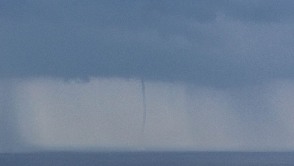
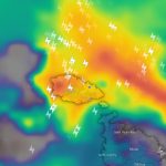
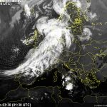
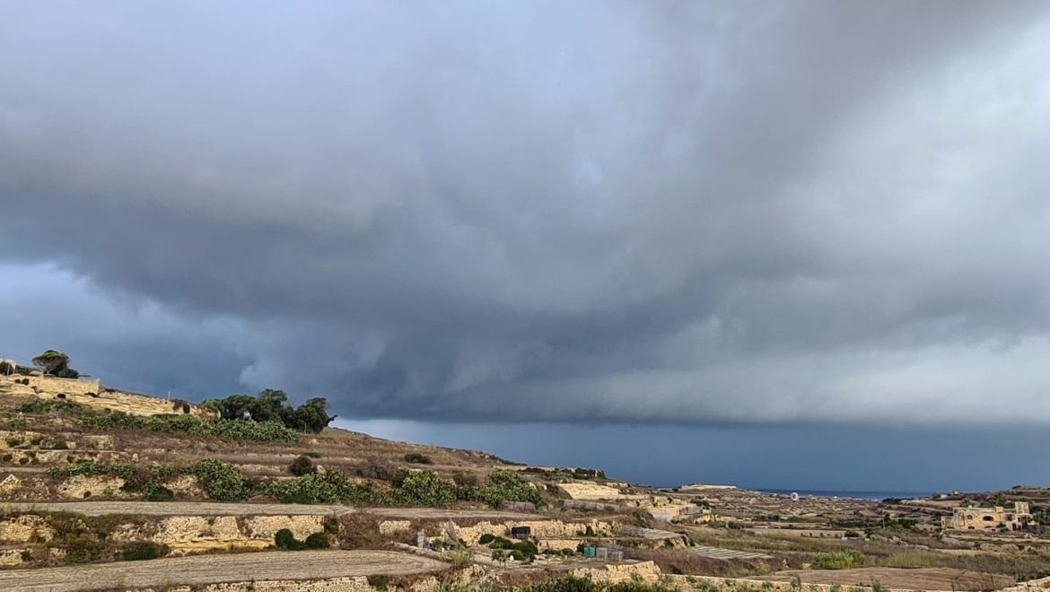
A moist and unstable atmosphere was present over the central Mediterranean, together with some wind shear (a difference in wind speed or direction over a relatively short distance in the atmosphere). A thunderstorm with an intense updraft (a current of rising air) ingested and tightened a rotating layer of air. This led to the formation of a confirmed funnel over fields near Għarb in Gozo. The funnel developed at around 10 a.m. and lasted for less than 5 minutes. It whipped dust and lose debris. The same cloud produced a downpour along the northeast coast of Gozo and Malta. Several other funnel clouds were reported over the past few days. The instability that led to the formation of this funnel was also responsible for the series of isolated thunderstorms that affected the Maltese Islands from Saturday 4/9 through to Sunday 12/9.

Thanks to Andrea Muscat and Joseph Casha for the photos and video!


Reports

A change in weather / Taqliba fit-temp

ENGLISH/INGLIŻ

The anticyclone that has dominated the meteorological scene across the central Mediterranean for weeks has weakened. We’ve already seen this over the weekend, a the first showers in months drenched parts of the Maltese Islands. The atmosphere above our region will become increasingly unstable and signs of the arrival of autumn will become more apparent. Air temperatures will likely stop exceeding 30°C, although real-feels will remain very warm due to high levels of humidity. Nights will become noticeably cooler. Sea surface temperatures will soon begin a downward trend too. The air will also be cleaner and not as hazy, after airborne dust is cleared away by the rain.

An unstable atmosphere above the central Mediterranean will mean incursions of cooler air from the north can reach us more easily. When this is pushed over the very warm sea, showers and thunderstorms form. We will experience this at the start of this week. There will be a chance of rain from the very early hours of Monday 6/9 till the very early hours of Wednesday 8/9. We will likely experience isolated thunderstorms which will be heavy and gusty at times. These showers will form erratically, making it extremely difficult to determine exactly when and where they will occur from well before-hand. Not all localities will be affected the same at a time. We still expect rainfall to be sufficient enough to continue easing the drought slowly, however. We will provide you with regular updates on the meteorological situation as the days progress.


MALTI / MALTESE

L-antiċklun li ddomina s-sitwazzjoni metereoloġika madwar il-Mediterran għal dawn l-aħħar ġimgħat qed jidgħajjef sew. Diġa rajna dawn matul tmiem il-ġimgħa, meta numru ta’ ħalbiet tax-xita laqtu xi lokalitijiet tal-Gżejjer Maltin. L-atmosfera fuq ir-reġjun tagħna se ssir dejjem aktar instabbli, u s-sinjali tal-ħarifa se jsiru dejjem aktar ċari. It-temperaturi ta’ l-arja mistenni jieqfu jaqbżu l-livell ta’ 30°C, għalkemm l-livelli għoljin ta’ umdita se jfissru aktar tidlik. L-iljieli se jkunu notevolment aktar friski. It-temperatura tal-baħar ukoll daqt tibda nieżla bil-mod. L-arja se ssir dejjem anqas imdaħħna, hekk kif it-trab fin jinżel max-xita.

L-atmosfera nstabbli ta’ fuq iċ-ċentru tal-Mediterran se tfisser li rqajja ta’ arja friska minn fuq l-Ewropa se jkunu jistgħu jibdew jilħquna aktar faċilment. Meta din tkun imbuttata fuq il-baħar sħun ta’ madwarna, jibdew jiżviluppaw il-ħalbiet tax-xita u maltempati bir-ragħad. Dan se nesperjenzawh fil-bidu ta’ din il-ġimgħa. Se jkun hemm ċans ta’ xita mis-siegħat bikrijin tat-Tnejn 6/9 sas-siegħat bikrijin ta’ l-Erbgħa 8/9. Jidher biċ-ċar li għandna nistennew maltempati bir-ragħad iżolati li se jkunu qawwijin u mirjieħa kultant. Dawn il-ħalbiet tax-xita se jkunu qed jiffurmaw b’mod erratiku, u b’hekk se jkun diffiċli ferm li ngħidu fejn se jkunu qed jaħkmu minn ħafna qabel. Mhux il-lokalitajiet kollha se jkunu qed jiġu affetwati ndaqs fl-istess waqt. Minekjja dan, xorta naħsbu li għandha tagħmel xita biżejjed biex tibda ttaffi n-nixfa li hemm madwar il-Gżejjer Maltin. Se nkunu qed inżommukom aġġornati kontinwament bl-aħħar żviluppi meterjoloġiċi.

End of Month Reports

Significantly Hotter than Average in August 2021

Air Temperature

Highest Maximum 37.3°C 1st
Lowest Maximum 29.1°C 30th 
Highest Minimum 27.7°C 5th
Lowest Minimum 21.1°C 20th


Mean Maximum 32.4°C
Mean Minimum 24.9°C
Mean 28.7°C


Relative Humidity

Highest Relative Humidity 94% 10th
Lowest Relative Humidity 27% 1st


Mean Relative Humidity 71.4%


Atmospheric Pressure

Highest Atmospheric Pressure 1021.2hPa 13th
Lowest Atmospheric Pressure 1010.0hPa 29th


Mean Atmospheric Pressure 1015.1hPa


Wind

Highest Gust 49.9km/h 1st


Mean Wind Speed 5.4km/h
Mean Gust Speed 12.2km/h
Mean Wind + Gust Speed 8.8km/h
Most Frequent Wind Direction Northwest


Precipitation

Total Rainfall During August 2021 0.0 mm
Total Rainfall Since Last 01/09 414.7 mm


Highest 24 Hour Total / /


Rain Days 0
Thunderstorm Days 0
Hail Days 0


August 2021 Compared to the Climate Means

  Climate Mean August 2021 Anomaly
Mean Maximum Temperature 31.4°C 32.4°C +1.0°C
Mean Minimum Temperature 22.7°C 24.9°C +2.2°C
Mean Temperature 27.1°C 28.7°C +1.6°C
Mean Relative Humidity 73% 71.4% -1.6%
Mean Atmospheric Pressure 1015.4hPa 1015.1hPa -0.3hPa
Mean Wind Speed 13.0 km/h 8.8 km/h -4.2 km/h
Most Frequent Wind Direction Northwest Northwest
Total Rainfall 7.9 mm 0.0 mm -7.9 mm
Total Rainfall Since Last 01/09 555.7 mm 414.7 mm -141.0 mm
Total Rain Days 0 days 0 days /
Total Thunderstorm Days 0 days 0 days /
Total Hail Days 0 days 0 days /


Significantly Hotter than Average in August 2021

August 2021 was the hottest month of the year. The mean temperature exceeded the norm by a staggering 1.6°C. Maximum temperatures were 1°C hotter than average. Nighttime lows were 2.2°C warmer than average. This wider anomaly may be attributed to the warmer than average sea surrounding the Maltese Islands. A very warm sea inhibits nighttime cooling. The hottest day was the 1st, with a maximum temperature of 37.3°C. Temperatures exceeded the 40°C mark on the day, in more central spots on Malta. A total of eighteen days registered a maximum temperature greater than the climate mean. The coolest temperature of 21.1°C was measured at dawn on the 20th. This was one of only a handful of nights with a minimum temperature dipping to below average.

A heavy rain shower was observed over a handful of localities in central Malta on 22nd August. Most places remained dry on the day, however. This extended the dry run for the driest of localities to 150 days.

Rainfall Reports

September 2020 to August 2021 Rainfall Report

The report is based on rainfall readings from our main weather station in Għarb. using a manual rain gauge set-up as per standards established by the World Meteorological Organization (WMO). Obviously, rainfall distribution varies widely from one location to another. For this reason, we have included a list of localities around the Maltese Islands along with their respective rainfall totals at the end of the report.


Precipitation Totals

Total Rainfall in September 2020 133.7 mm
Total Rainfall in October 2020 32.5 mm
Total Rainfall in November 2020 86.6 mm
Total Rainfall in December 2020 94.1 mm
Total Rainfall in January 2021 41.4 mm
Total Rainfall in February 2021* 3.4 mm
Total Rainfall in March 2021 21.6 mm
Total Rainfall in April 2021 1.4 mm
Total Rainfall in May 2021 0.0 mm
Total Rainfall in June 2021 0.0 mm
Total Rainfall in July 2021 0.0 mm
Total Rainfall in August 2021 0.0 mm

* February 2021 was among the driest Februaries on record


Total Rainfall from 1st September 2020 till 31st August 2021 414.7 mm


Highest 24 Hour Total 112.1 mm 14th September 2020


Rain Days 72 days
Thunderstorm Days 29 days
Hail Days 14 days


2020/2021 Precipitation Compared to the Climate Means

  Climate Mean 2020/2021 Anomaly
Total Rainfall in September 49.9 mm 133.7 mm +83.8 mm
Total Rainfall in October 89.0 mm 32.5 mm -56.5 mm
Total Rainfall in November 90.1 mm 86.6 mm -3.5 mm
Total Rainfall in December 97.1 mm 94.1 mm -3.0 mm
Total Rainfall in January 85.4 mm 41.4 mm -44.0 mm
Total Rainfall in February 61.5 mm 3.4 mm -58.1 mm
Total Rainfall in March 39.8 mm 21.6 mm -18.2 mm
Total Rainfall in April 20.9 mm 1.4 mm -19.5 mm
Total Rainfall in May 9.9 mm 0.0 mm -9.9 mm
Total Rainfall in June 3.9 mm 0.0 mm -3.9 mm
Total Rainfall in July 0.3 mm 0.0 mm -0.3 mm
Total Rainfall in August 7.9 mm 0.0 mm -7.9 mm


  Climate Mean 2020/2021 Anomaly
Total Rainfall Since Last 01/09 555.7 mm 414.7 mm -141.0 mm


  Climate Mean 2020/2021 Anomaly
Total Rain Days 77 days 72 days -5 days
Total Thunderstorm Days 26 days 29 days +3 days
Total Hail Days 8 days 14 days +6 days


Rainfall Events

Date Rainfall Description
06/09/2020 0.3 mm Light Rain Shower (Distant Thunderstorms)
07/09/2020 TR mm Spots of Rain (Isolated Thunderstorm in Malta)
13/09/2020 15.3 mm Moderate Thunderstorm; Light Rain
14/09/2020 112.1 mm Heavy Thunderstorm and Hail
16/09/2020 2.5 mm Isolated Thunderstorm (Heavier in Malta)
22/09/2020 0.1 mm Spots of Rain
23/09/2020 1.1 mm Isolated Shower
27/09/2020 2.3 mm Blustery Thundery Shower
05/10/2020 0.5 mm Drizzle; Distant Thunder
06/10/2020 1.4 mm Isolated Thunderstorm
12/10/2020 3.6 mm Intermittent Light Rain
13/10/2020 0.3 mm Isolated Shower
19/10/2020 7.6 mm Periods of Rain
27/10/2020 12.3 mm Thunderstorm; Brief Light Rain
28/10/2020 6.8 mm Heavy Rain Shower
08/11/2020 0.1 mm Spots of Rain
15/11/2020 3.2 mm Isolated Shower
17/11/2020 17.9 mm Thunderstorm; Periods of Rain
21/11/2020 13.8 mm Isolated Showers; Thunderstorm
22/11/2020 9.4 mm Light Rain; Thunderstorm with Hail
23/11/2020 6.2 mm Showers; Distant Thunder
24/11/2020 8.3 mm Showers; Distant Thunder
25/11/2020 10.8 mm Showers; Distant Thunder
26/11/2020 0.8 mm Light Rain
02/12/2020 4.7 mm Showers
03/12/2020 6.9 mm Showers; Distant Thunder
04/12/2020 0.3 mm Light Rain
06/12/2020 2.9 mm Showers; Distant Thunder; Hail
07/12/2020 1.4 mm Showers
09/12/2020 3.6 mm A.M. Light Rain; P.M. Thundery Rain/Hail Shower
10/12/2020 0.7 mm Light Rain
11/12/2020 8.0 mm Showers
12/12/2020 16.0 mm Thundery Rain/Hail Shower
13/12/2020 1.3 mm P.M. Shower
19/12/2020 6.9 mm P.M. Thunderstorm
20/12/2020 6.8 mm Showers; Distant Thunder
21/12/2020 20.6 mm Thunderstorm with Hail
26/12/2020 1.7 mm P.M. Isolated Shower
27/12/2020 12.3 mm Blustery Rain/Hail Showers
01/01/2021 0.6 mm P.M. Shower
02/01/2021 8.5 mm Isolated Thunderstorm
03/01/2021 4.3 mm P.M. Rain/Hail Showers; Distant Thunder
04/01/2021 3.2 mm A.M. Rain/Hail Showers
08/01/2021 0.3 mm Light Rain
12/01/2021 2.3 mm Rain/Hail Showers
13/01/2021 0.5 mm Light Rain
14/01/2021 0.3 mm Light Rain
15/01/2021 1.5 mm Isolated Shower
16/01/2021 1.7 mm Isolated Rain/Hail Shower
17/01/2021 1.6 mm Isolated Shower (Hailstorm in Malta)
18/01/2021 2.1 mm Shower
23/01/2021 0.3 mm Light Rain
24/01/2021 0.3 mm Light Rain
26/01/2021 5.9 mm Showers
27/01/2021 0.5 mm Light Rain
28/01/2021 7.2 mm Showers
31/01/2021 0.3 mm Light Rain
02/02/2021 1.8 mm Isolated Shower
13/02/2021 1.1 mm Light Rain
14/02/2021 0.5 mm Light Rain
08/03/2021 1.3 mm Light Rain
09/03/2021 0.3 mm Light Rain
10/03/2021 0.9 mm Light Rain
16/03/2021 3.7 mm Isolated Thundery Shower (Hailstorm in Malta)
18/03/2021 3.6 mm Isolated Showers
20/03/2021 0.5 mm Light Rain
21/03/2021 4.6 mm Showers
22/03/2021 0.8 mm Light Rain
23/03/2021 5.6 mm Showers (Hailstorm in Malta)
30/03/2021 0.3 mm Heavy Dew
05/04/2021 1.4 mm Isolated Shower


Comparing 2020/2021 to Previous Years

2010/2011 – 508.4 mm

2011/2012 – 668.0 mm

2012/2013 – 461.3 mm

2013/2014 – 454.7 mm

2014/2015 – 657.0 mm

2015/2016 – 265.0 mm

2016/2017 – 349.1 mm

2017/2018 – 441.2 mm

2018/2019 – 505.2 mm

2019/2020 – 406.0 mm

2020/2021 – 414.7 mm


Comparing Different Localities

Għarb – 414.7 mm

Victoria – 421.6 mm

Xewkija – 400.1 mm

Nadur – 348.8 mm

Mellieħa – 282.6 mm

Buġibba – 345.6 mm

Mġarr (Malta) – 308.1 mm

Għargħur – 415.4 mm

Attard – 505.0 mm

Dingli – 334.8 mm

Msida – 452.9 mm

Valletta – 267.5 mm

Luqa – 444.3 mm

Imqabba – 408.1 mm

Żabbar – 479.2 mm

Birżebbuġa – 317.6 mm

Average – 368.5 mm

End of Month Reports

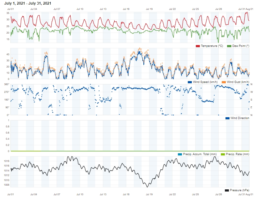
Hotter than Average in July 2021

Air Temperature

Highest Maximum 35.8°C 31st
Lowest Maximum 26.4°C 17th 
Highest Minimum 26.3°C 31st
Lowest Minimum 21.8°C 19th


Mean Maximum 30.9°C
Mean Minimum 23.7°C
Mean 27.3°C


Relative Humidity

Highest Relative Humidity 93% Several Days
Lowest Relative Humidity 18% 3rd and 4th


Mean Relative Humidity 71.0%


Atmospheric Pressure

Highest Atmospheric Pressure 1020.0hPa 8th
Lowest Atmospheric Pressure 1006.7hPa 18th


Mean Atmospheric Pressure 1015.0hPa


Wind

Highest Gust 49.9km/h 17th


Mean Wind Speed 8.1km/h
Mean Gust Speed 15.4km/h
Mean Wind + Gust Speed 11.8km/h
Most Frequent Wind Direction Northwest


Precipitation

Total Rainfall During July 2021 0.0 mm
Total Rainfall Since Last 01/09 414.7 mm


Highest 24 Hour Total / /


Rain Days 0
Thunderstorm Days 0
Hail Days 0


July 2021 Compared to the Climate Means

  Climate Mean July 2021 Anomaly
Mean Maximum Temperature 31.2°C 30.9°C -0.3°C
Mean Minimum Temperature 21.8°C 23.7°C +1.9°C
Mean Temperature 26.5°C 27.3°C +0.8°C
Mean Relative Humidity 69% 71.0% +2.0%
Mean Atmospheric Pressure 1015.7hPa 1015.0hPa -0.7hPa
Mean Wind Speed 13.3 km/h 11.8 km/h -1.5 km/h
Most Frequent Wind Direction Northwest Northwest
Total Rainfall 0.3 mm ed-hrvatski.com 0.0 mm -0.3 mm
Total Rainfall Since Last 01/09 548.3 mm 414.7 mm -133.6 mm
Total Rain Days 0 days 0 days /
Total Thunderstorm Days 0 days 0 days /
Total Hail Days 0 days 0 days /


Hotter than Average in July 2021

Sixteen July days registered a maximum air temperature that surpassed the climate norm of 31.2°C. A spell of cool, windy weather halfway through the month meant a slightly cooler than average mean monthly maximum temperature. In a stark contrast to this, nighttime minimum temperatures were a staggering 1.9°C warmer than average. This may be attributed to the warmer than average sea surrounding the Maltese Islands. A very warm sea inhibits nighttime cooling. On the last day of July, the air temperature peaked at 35.8°C in Għarb, with a handful of localities around Malta registering a maximum temperature as high as 40°C. Other parts of Europe sizzled in even hotter temperatures as well.

The month of July was generally calm. The mean wind speed of 11.8km/h was in line with the climate norm. The maximum gust last month was registered on the 17th, at 49.9 km/h, when a zone of instability brought a spell of cool, windy weather to the Maltese Islands.

Unsurprisingly, July lived up to its expectation of being a bone dry month across Malta. There was no rain across the Maltese Islands at any point last month.

End of Month Reports

June 2021 brings Record-Breaking Temperatures

Air Temperature

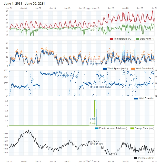
Highest Maximum 40.8°C 30th
Lowest Maximum 23.3°C 8th and 9th
Highest Minimum 27.2°C 23rd
Lowest Minimum 17.8°C 5th


Mean Maximum 30.2°C
Mean Minimum 21.4°C
Mean 25.8°C


Relative Humidity

Highest Relative Humidity 93% Several Days
Lowest Relative Humidity 18% 25th and 28th


Mean Relative Humidity 63.4%


Atmospheric Pressure

Highest Atmospheric Pressure 1025.8hPa schweiz-libido.com 4th
Lowest Atmospheric Pressure 1012.2hPa 22nd


Mean Atmospheric Pressure 1017.5hPa


Wind

Highest Gust 56.3km/h 26th


Mean Wind Speed 7.6km/h
Mean Gust Speed 15.4km/h
Mean Wind + Gust Speed 11.5km/h
Most Frequent Wind Direction Northwest


Precipitation

Total Rainfall During June 2021 0.0 mm
Total Rainfall Since Last 01/09 414.7 mm


Highest 24 Hour Total / /


Rain Days 0
Thunderstorm Days 0
Hail Days 0


June 2021 Compared to the Climate Means

  Climate Mean June 2021 Anomaly
Mean Maximum Temperature 28.2°C 30.2°C +2.0°C
Mean Minimum Temperature 19.3°C 21.4°C +1.1°C
Mean Temperature 23.8°C 25.8°C +2.0°C
Mean Relative Humidity 71% 63.4% -7.6%
Mean Atmospheric Pressure 1015.8hPa 1017.5hPa +1.7hPa
Mean Wind Speed 15.2 km/h 11.5 km/h -3.7 km/h
Most Frequent Wind Direction Northwest Northwest
Total Rainfall 4.4 mm 0.0 mm -4.4 mm
Total Rainfall Since Last 01/09 548.0 mm 414.7 mm -133.3 mm
Total Rain Days 1 day 0 days -1 day
Total Thunderstorm Days 0 days 0 days /
Total Hail Days 0 days 0 days /


June 2021 brings Record-Breaking Temperatures

With a monthly average temperature of 25.8°C, June 2021 was a solid 2.0°C hotter than the climate norm. It was also the third hottest June on record in the Maltese Islands. Only those of 2019 and 2003 were hotter. The average maximum temperature was calculated at 30.2°C, surpassing the average for a normal June by 2.0°C. Nights were also rather warm. The average minimum temperature of 21.4°C exceeded the mean by 1.1°C. Using the national criteria for a heatwave, we can conclude that the Maltese Islands experienced one heatwaves during this month. This heat wave broke records. Lasting from 20th June through to 30th June (both days included), it ended up being the longest heatwave experienced locally. The previous record of 10 days was set in August 2017. The heat wave’s final day, 30th June, broke the record for the hottest June day ever. The temperature at our weather station in Għarb soared to 40.8°C on that day. An even higher value of 41.5°C was recorded at Malta International Airport. One other thing worth noting were the unseasonably cool first half of June. All days up till the 18th were cooler than average.

The difference in pressure between instability over the western Mediterranean and seasonal high pressure over the Sahara Desert set-up a stream of air from the Sahara Desert towards the western Mediterranean. This helped blow very hot air from the Sahara Desert across the central and southern Mediterranean. This state of affairs resulted in what we know as a heat dome. A heat dome is a weather phenomenon in which high-pressure atmospheric conditions trap air coming in from the Sahara Desert. The trapped air heats up at an alarming rate as it is compressed, like what happens under the lid on a saucepan. In normal conditions, winds are able to move a heat dome around, but because this particular heat dome stretched high into the atmosphere, it wasn’t easy to move about. This led to the persistent heatwave. The heat dome caused air pollution, desert sand and moisture to become stagnant, leading to a choked up atmosphere.

With the exception of an isolated shower on the 2nd, June 2021 was completely dry across the Maltese Islands. The last time a shower of over 1 mm affected our weather station in Għarb was way back in April.

Levels of relative humidity were also extremely low when compared to the norm. This was due to the relentless intense heat in the second half of the month. Several consecutive days with an average relative humidity in the region of 50% were registered. The driest days were the 25th and the 28th, with minimum readings of 18% on both.

Atmospheric pressure was slightly higher than the mean for this time of year, as stronger and more persistent anticyclonic behavior.


r was noted.

Maximum wind gusts reached at least Force 5 on eighteen days last month. The highest wind gust was of 56.3 km/h, on the 26th.


End of Month Reports

Completely Dry and Warmer in May 2021

Air Temperature

Highest Maximum 31.0°C 17th
Lowest Maximum 20.7°C 20th
Highest Minimum 18.6°C 29th, 30th and 31st 
Lowest Minimum 14.0°C 13th


Mean Maximum 24.5°C
Mean Minimum 16.7°C
Mean 20.1°C


Relative Humidity

Highest Relative Humidity 94% Several Days
Lowest Relative Humidity 21% 16th


Mean Relative Humidity 67.9%


Atmospheric Pressure

Highest Atmospheric Pressure 1024.1hPa 4th
Lowest Atmospheric Pressure 1014.0hPa 1st


Mean Atmospheric Pressure 1019.0hPa


Wind

Highest Gust 53.1km/h 20th


Mean Wind Speed 6.6km/h
Mean Gust Speed 16.1km/h
Mean Wind + Gust Speed 11.4km/h
Most Frequent Wind Direction Northwest


Precipitation

Total Rainfall During May 2021 0.0 mm
Total Rainfall Since Last 01/09 414.7 mm


Highest 24 Hour Total / /


Rain Days 0
Thunderstorm Days 0
Hail Days 0


May 2021 Compared to the Climate Means

  Climate Mean May 2021 Anomaly
Mean Maximum Temperature 23.4°C 24.5°C +1.1°C
Mean Minimum Temperature 15.8°C 16.7°C +0.9°C
Mean Temperature 19.6°C 20.1°C +0.5°C
Mean Relative Humidity 74% 67.9% -6.1%
Mean Atmospheric Pressure 1015.3hPa 1019.0hPa +3.7hPa
Mean Wind Speed 17.0 km/h 11.4 km/h -5.6 km/h
Most Frequent Wind Direction Northwest Northwest
Total Rainfall 9.9 mm 0.0 mm -9.9 mm
Total Rainfall Since Last 01/09 543.6 mm 414.7 mm -128.9 mm
Total Rain Days 3 days 0 days -3 days
Total Thunderstorm Days 1 day 0 days -1 day
Total Hail Days 0 days 0 days /


Completely Dry and Warmer in May 2021

May 2021 was characterized by its warmer than average temperatures. Successive pressure systems of north African origin traversed the central Mediterranean last month, carrying with them warm air masses from over the Sahara Desert. The overall mean temperature of 20.1°C was half a degree warmer than the mean. The warmest day in May 2021 was the 17th, with a daytime high of 31.0°C being registered on the day. This was the only day with a maximum temperature of 30°C +

No rain was measured over the course of May 2021. This may be down to prevalent ridges of high pressure across the eastern Mediterranean which were sufficient enough to keep rain away from the central Mediterranean. Another probable contributing factor to this was the frequent prescence of layers of warm and dry air aloft. This caused any falling precipitation to re-evaporate before reaching the ground. Evidence supporting this theory was the regular appearance of virga clouds.

May 2021 lived up to its expectation of being a breezy month. In fact, 16 days featured wind speeds of at least Force 5 at times.