Reports

End of Month Reports

Almost Completely Dry in April 2021

Air Temperature

Highest Maximum 25.4°C 29th
Lowest Maximum 14.7°C 5th
Highest Minimum 16.4°C 29th 
Lowest Minimum 8.3°C 9th


Mean Maximum 18.9°C
Mean Minimum 13.1°C
Mean 16.0°C


Relative Humidity

Highest Relative Humidity 95%  30th
Lowest Relative Humidity 40% 30th


Mean Relative Humidity 75.3%


Atmospheric Pressure

Highest Atmospheric Pressure 1029.8hPa 9th
Lowest Atmospheric Pressure 1005.6hPa 27th


Mean Atmospheric Pressure 1016.4hPa


Wind

Highest Gust 72.4km/h schweiz-libido.com 16th


Mean Wind Speed 11.4km/h
Mean Gust Speed 20.5km/h
Mean Wind + Gust Speed 15.9km/h
Most Frequent Wind Direction East Southeast


Precipitation

Total Rainfall During April 2021 1.4 mm
Total Rainfall Since Last 01/09 414.7 mm


Highest 24 Hour Total 1.4 mm 5th 


Rain Days 1
Thunderstorm Days 0
Hail Days 0


Rainfall Events


05/04/2021 1.4 mm Isolated Shower


April 2021 Compared to the Climate Means

  Climate Mean April 2021 Anomaly
Mean Maximum Temperature 19.4°C 18.9°C -0.5°C
Mean Minimum Temperature 12.8°C 13.1°C +0.3°C
Mean Temperature 16.1°C 15.9°C -0.2°C
Mean Relative Humidity 77% 75.3% -1.7%
Mean Atmospheric Pressure 1014.3hPa 1016.4hPa +2.1hPa
Mean Wind Speed 18.9 km/h 15.9 km/h -3.0 km/h
Most Frequent Wind Direction Northwest East Southeast
Total Rainfall 20.9 mm 1.4 mm -19.5 mm
Total Rainfall Since Last 01/09 533.7 mm 414.7 mm -119.0 mm
Total Rain Days 5 days 1 day -4 days
Total Thunderstorm Days 1 day 0 days -1 day
Total Hail Days 1 day 0 days -1 day


Almost Completely Dry in April 2021

April 2021 was another month with temperatures around the average. Overall, temperatures were marginally below the mean for the time of year. Days were slightly cooler, while nights were a bit warmer. This was the result of persistent anticyclones over Europe directing colder air from the north towards the central Mediterranean. A brief cool spell towards the start of the month registered April’s lowest temperature readings. With a nighttime low of 8.3°C, the morning of the 9th was the coolest last month. The warmest day in April 2021 was the 29th. A daytime high of 25.4°C was registered on the day, as a warm stream of air from the Sahara blew across the central Mediterranean.

An isolated shower on the 5th brought last month’s only measurable rain. With the exception of a few drops of dusty rain on a few days, April 2021 was otherwise completely dry. Although spring is synonymous with frequent days of grey skies and airborne fine dust, last month did exceed expectation.

With regards to wind, April 2021 featured dominant southerly winds. The most frequent wind direction last month was the East Southeast. Half of the days in April 2021 were characterized by winds blowing from the southern quadrant. April 2021 lived up to its expectation of being a wind-swept month. Gusts of at least Force 6 were recorded on a staggering 16 days, the highest of which was one of 72.4km/h (Force 8), measured on the 16th. This was during the passage of a north African low. Accompanying most windy days were grey skies and airborne fine dust.

End of Month Reports

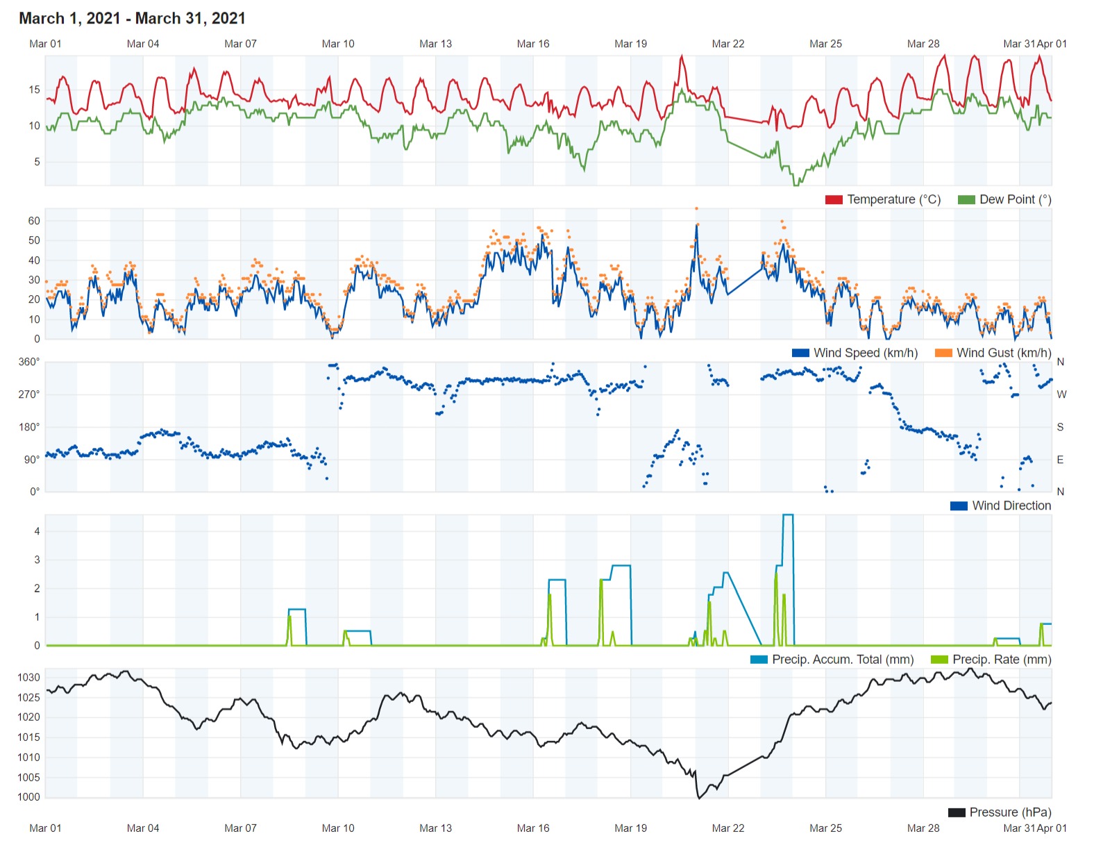
Cooler but Drier in March 2021

Air Temperature

Highest Maximum 19.7°C 29th
Lowest Maximum 12.6°C 23rd
Highest Minimum 13.3°C 6th 
Lowest Minimum 7.2°C 23rd


Mean Maximum 16.4°C
Mean Minimum 11.2°C
Mean 13.8°C


Relative Humidity

Highest Relative Humidity 95%  21st
Lowest Relative Humidity 40% 15th


Mean Relative Humidity 75.4%


Atmospheric Pressure

Highest Atmospheric Pressure 1032.2hPa 29th
Lowest Atmospheric Pressure 998.3hPa 21st


Mean Atmospheric Pressure 1020.1hPa


Wind

Highest Gust 66.0km/h 21st


Mean Wind Speed 11.2km/h
Mean Gust Speed 20.8km/h
Mean Wind + Gust Speed 16.0km/h
Most Frequent Wind Direction Northwest


Precipitation

Total Rainfall During March 2021 21.6 mm
Total Rainfall Since Last 01/09 413.3 mm


Highest 24 Hour Total 5.6 mm 23rd 


Rain Days 10
Thunderstorm Days 2
Hail Days 2


Rainfall Events

08/03/2021 1.3 mm Light Rain
09/03/2021 0.3 mm Light Rain
10/03/2021 0.9 mm Light Rain
16/03/2021 3.7 mm Isolated Showers; Thundery Shower with Hail
18/03/2021 3.6 mm Isolated Showers
20/03/2021 0.5 mm Light Rain (with heavy sand deposits)
21/03/2021 4.6 mm Showers
22/03/2021 0.8 mm Light Rain
23/03/2021 5.6 mm Showers; Thundery Shower with Hail
30/03/2021 0.3 mm Dew


March 2021 Compared to the Climate Means

  Climate Mean March 2021 Anomaly
Mean Maximum Temperature 17.0°C 16.4°C -0.6°C
Mean Minimum Temperature 10.9°C 11.2°C +0.3°C
Mean Temperature 14.0°C 13.8°C -0.2°C
Mean Relative Humidity 79% 75.4% -3.6%
Mean Atmospheric Pressure 1016.1hPa 1020.1hPa +4.0hPa
Mean Wind Speed 18.9 km/h 16.0 km/h -2.9 km/h
Most Frequent Wind Direction Northwest Northwest
Total Rainfall 39.8 mm 21.6 mm -18.2 mm
Total Rainfall Since Last 01/09 512.8 mm 413.3 mm -99.5 mm
Total Rain Days 7 days 10 days +3 days
Total Thunderstorm Days 2 days 2 days 0 day
Total Hail Days 1 day 2 days +1 day


Cooler but Drier in March 2021 

March 2021 was the first month in a while to register an overall temperature which was cooler than average. Overall, temperatures were 0.2°C. Whilst maximum temperatures were much cooler than the norm, nighttime lows were marginally warmer. This was due to anticyclones over Europe directing colder air from the north towards the central Mediterranean. The start of astronomical spring was marked by a week-long cold spell that brought temperatures as low as 7.2°C to our shores. The warmest day last month was the 29th, when a daytime high of 19.7°C was registered. This was unseasonably cool, as March is typically synonymous with the return of 20°C + temperatures locally.

With rainfall amounting to a total of 21.6 mm over the course  of last month, March 2021 was drier than average. Rainfall was just over a half of the climate norm. The rain was spread over 10 days. Although this value incorporates one occurrence of a heavy dewfall, it still is more than the value expected for March. Thunder was heard on two days. Hail was recorded on two days as well.

A number of windy days dotted the month of March. In fact, 10 days last month featured a wind speed of at least Force 6. The highest wind gust last month was measured at 66.0 km/h (Force 6) from the East Southeast. This was early on the 21st, as a vigorous low pressure system emerged from north Africa and traversed the central Mediterranean. Accompanying this strong wind were dense fog patches and light rain which deposited copious amounts of desert sand.

Several episodes of sea fog were experienced last month. Sea fog forms when a warm and moist air mass from the south is advected over a cooler area of sea. The air mass cools and its temperature falls to the dew point (the temperature at which an air mass becomes saturated and the water vapour in it condenses). As the air slides over the cooler area of sea it becomes increasingly saturated, enhancing the formation of condensation. Normally, sea fog dissipates as it moves inland. However, given that the air on land is very similar to that of the sea at this time of year, the fog persists inland too.


Rainfall Totals around the Maltese Islands in March 2021 (and since last September 1st)

Għarb – 21.6 mm (413.3 mm)

Victoria – 31.5 mm (431.0 mm)

Xewkija – 23.8 mm (347.8 mm)

Nadur – 27.8 mm (486.6 mm)

Mellieħa – 20.2 mm (284.0 mm)

Buġibba – 32.0 mm (343.6 mm)

Mġarr – 17.6 mm (306.7 mm)

Għargħur – 22.8 mm (413.1 mm)

Attard – 36.9 mm (500.2 mm)

Rabat – 27.4 mm (331.0 mm)

Msida – 32.8 mm (449.7 mm)

Valletta – 12.9 mm (266.5 mm)

Luqa – 29.3 mm (443.8 mm)

Żabbar – 37.8 mm (478.0 mm)

Birżebbuġa – 23.4 mm (325.8 mm)

End of Month Reports

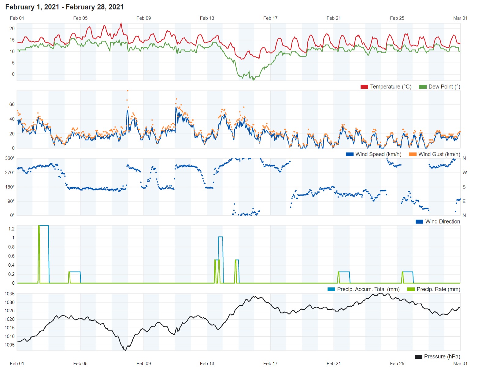
February 2021 among the driest ever

Air Temperature

Highest Maximum 22.2°C 7th
Lowest Maximum 10.2°C 15th
Highest Minimum 15.1°C 6th 
Lowest Minimum 5.9°C 16th


Mean Maximum 16.9°C
Mean Minimum 11.4°C
Mean 14.1°C


Relative Humidity

Highest Relative Humidity 94%  4th
Lowest Relative Humidity 43% 15th


Mean Relative Humidity 76.6%


Atmospheric Pressure

Highest Atmospheric Pressure 1035.2hPa 23rd and 24th
Lowest Atmospheric Pressure 1001.0hPa 7th


Mean Atmospheric Pressure 1021.9hPa


Wind

Highest Gust 78.9km/h 7th


Mean Wind Speed 9.3km/h
Mean Gust Speed 18.1km/h
Mean Wind + Gust Speed 13.7km/h
Most Frequent Wind Direction Northwest


Precipitation

Total Rainfall During February 2021 3.4 mm
Total Rainfall Since Last 01/09 391.7 mm


Highest 24 Hour Total 1.8 mm 2nd 


Rain Days 3
Thunderstorm Days 0
Hail Days 0


Rainfall Events

02/02/2021 1.8 mm Isolated Shower
13/02/2021 1.1 mm Light Rain
14/02/2021 0.5 mm Light Rain


February 2021 Compared to the Climate Means

  Climate Mean February 2021 Anomaly
Mean Maximum Temperature 15.5°C 16.9°C +1.4°C
Mean Minimum Temperature 9.6°C 11.4°C +1.8°C
Mean Temperature 12.6°C 14.1°C +1.5°C
Mean Relative Humidity 78% 76.6% -1.4%
Mean Atmospheric Pressure 1016.6hPa 1021.9hPa +5.3hPa
Mean Wind Speed 19.1 km/h 13.7 km/h -5.4 km/h
Most Frequent Wind Direction Northwest Northwest
Total Rainfall 61.5 mm 3.4 mm -58.1 mm
Total Rainfall Since Last 01/09 473.0 mm 391.7 mm -81.3 mm
Total Rain Days 10 days 3 days -7 days
Total Thunderstorm Days 3 days 0 days -3 days
Total Hail Days 1 day 0 days -1 day


February 2021 among the driest ever

Leave for a few days halfway through the month, February 2021 was a very mild one. Overall, temperatures were a staggering 1.5°C above the climate norm. With a maximum temperature of 10.2°C, the 15th was last month’s coldest day. The air temperature before dawn on the 16th dipped to a cold 5.9°C, making it the coldest night of February 2021. The vast majority of days last month featured comfortable temperatures, with daytime highs in the region of 17°C and nighttime lows of around 11°C being the most common values. The temperature also shot up to above 20°C on three days (the 5th, 6th and 7th).

Rain over the course of February 2021 was very scarce. In fact, it was among the driest ever. Only 3.4 mm were measured in Għarb. That is just 5% of the climate average. This was spread over three days. The rain was light on all three occasions. Although the situation may not have been as dire in other localities around the Maltese Islands, no area of the nation accumulated more than 10 mm of rain over the course of last month.

The mean reading of atmospheric pressure for February 2021 was of 1021.9hPa. This is much higher than the typical value for this time of year. This was due to an anticyclone that formed halfway through the month and remained stationary over the central Mediterranean till its end. This anticyclone saw readings exceeding 1030hPa on a number of days. The first half of the month was less stable.

The wind reached strengths of Force 7 on 5 days, Force 8 on 1 day and Force 9 on 1 day. All seven windy occurred in the less settled first half of the month. The strongest gust recorded was that of 78.9 km/h. This was on the 7th. The second half of last month feature a long and uninterrupted run of light winds. The wind blew from southerly quadrants on an astonishing twelve days.


Rainfall Totals around the Maltese Islands in February 2021 (and since last September 1st)

Għarb – 3.4 mm (391.7 mm)

Victoria – 4.6 mm (399.5 mm)

Xewkija – 2.7 mm (324.0 mm)

Nadur – 2.9 mm (458.8 mm)

Mellieħa – 2.0 mm (263.8 mm)

Buġibba – 3.0 mm (311.6 mm)

Mġarr – 1,8 mm (289.1 mm)

Għargħur – 1.3 mm (390.3 mm)

Attard – 3.6 mm (463.3 mm)

Rabat – 3.7 mm (303.6 mm)

Msida – 8.4 mm (416.9 mm)

Valletta – 0.0 mm (253.6 mm)

Luqa – 9.1 mm (414.5 mm)

Żabbar – 9.2 mm (440.2 mm)

Birżebbuġa – 4.1 mm (302.4 mm)

End of Month Reports

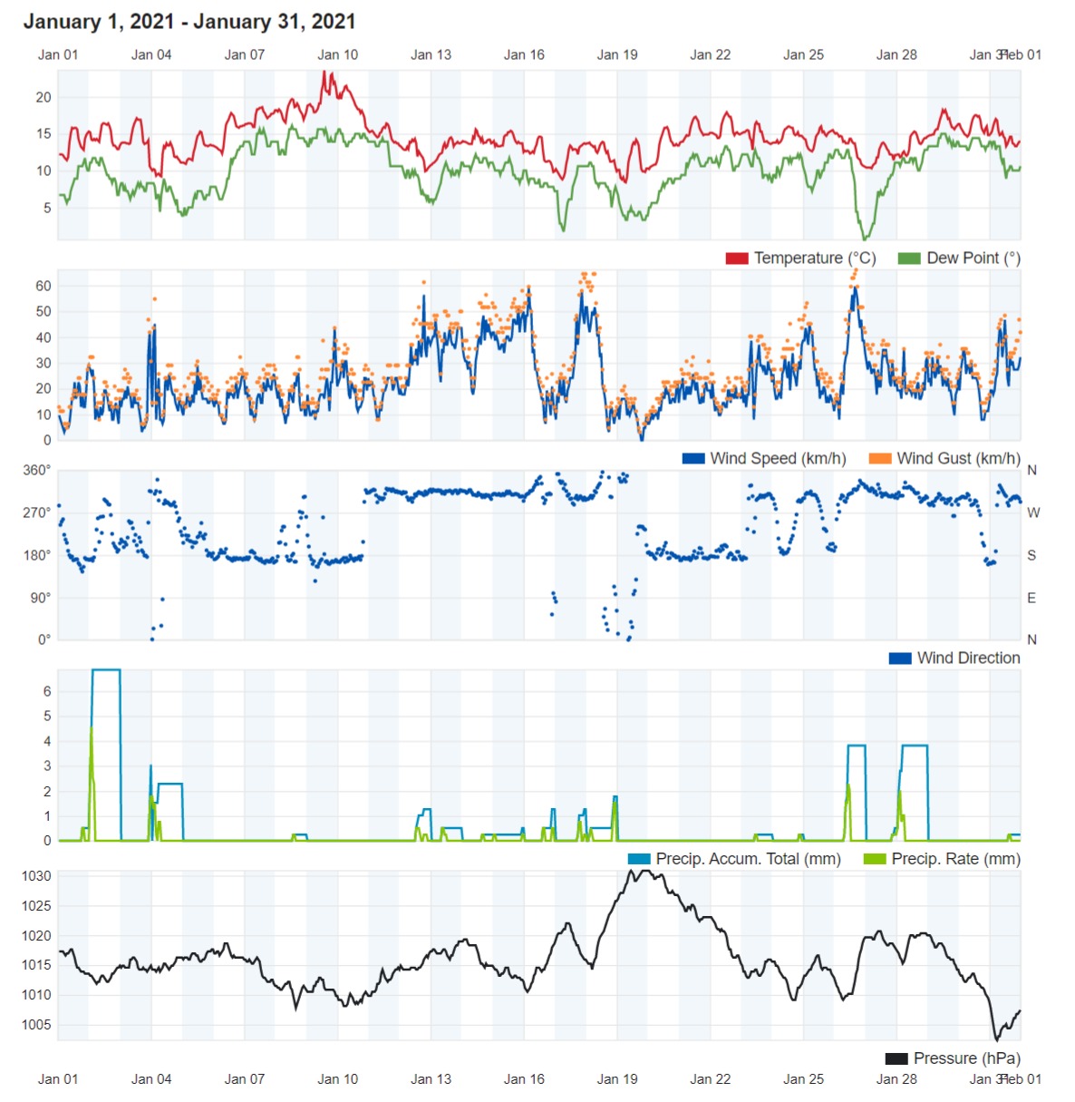
January 2021 registers warmest ever January day

Air Temperature

Highest Maximum 23.6°C 9th
Lowest Maximum 13.7°C 17th
Highest Minimum 17.1°C 9th 
Lowest Minimum 7.9°C 19th


Mean Maximum 16.4°C
Mean Minimum 11.8°C
Mean 14.1°C


Relative Humidity

Highest Relative Humidity 94%  28th
Lowest Relative Humidity 43% 26th


Mean Relative Humidity 74.5%


Atmospheric Pressure

Highest Atmospheric Pressure 1030.8hPa 19th and 20th
Lowest Atmospheric Pressure 1001.7hPa 31st


Mean Atmospheric Pressure 1015.6hPa


Wind

Highest Gust 66.0km/h 26th


Mean Wind Speed 12.1km/h
Mean Gust Speed 23.0km/h
Mean Wind + Gust Speed 17.6km/h
Most Frequent Wind Direction Northwest


Precipitation

Total Rainfall During January 2021 41.4 mm
Total Rainfall Since Last 01/09 388.3 mm


Highest 24 Hour Total 8.5 mm 2nd 


Rain Days 18
Thunderstorm Days 4
Hail Days 5


Rainfall Events


01/01/2021 0.6 mm P.M. Shower
02/01/2021 8.5 mm Isolated Thunderstorm
03/01/2021 4.3 mm P.M. Rain/Hail Showers; Distant Thunder
04/01/2021 3.2 mm A.M. Rain/Hail Showers; Distant Thunder
08/01/2021 0.3 mm Isolated Light Rain
12/01/2021 2.3 mm Rain/Hail Showers
13/01/2021 0.5 mm Light Rain
14/01/2021 0.3 mm Light Rain
15/01/2021 1.5 mm Isolated Shower
16/10/2021 1.7 mm Isolated Rain/Hail Shower
17/01/2021 1.6 mm Isolated Shower (Hailstorm in Malta)
18/01/2021 2.1 mm Shower
23/01/2021 0.3 mm Light Rain
24/01/2021 0.3 mm Light Rain
26/01/2021 5.9 mm Showers
27/01/2021 0.5 mm Light Rain
28/01/2021 7.2 mm Showers
31/01/2021 0.3 mm Light Rain


January 2021 Compared to the Climate Means

  Climate Mean January 2021 Anomaly
Mean Maximum Temperature 15.4°C 16.4°C +1.0°C
Mean Minimum Temperature 9.9°C 11.8°C +1.9°C
Mean Temperature 12.7°C 14.1°C +1.4°C
Mean Relative Humidity 79% 74.5% -4.5%
Mean Atmospheric Pressure 1018.2hPa 1015.6hPa -2.6hPa
Mean Wind Speed 18.9 km/h 17.6 km/h -1.3 km/h
Most Frequent Wind Direction Northwest Northwest
Total Rainfall 85.4 mm 41.4 mm -44.0 mm
Total Rainfall Since Last 01/09 411.5 mm 388.3 mm -23.2 mm
Total Rain Days 13 days 18 days +5 days
Total Thunderstorm Days 3 days 4 days +1 day
Total Hail Days 1 day 5 days +4 days


January 2021 registers warmest ever January day

January 2021 was an extremely mild one for the Maltese Islands. Overall, temperatures were almost 1.5°C warmer than the climate norm. With a mean minimum temperature of 11.8°C, nights were a staggering 1.9°C warmer than average. For five days, around mid-January, the Maltese Islands experienced what will likely be the coldest part of winter. The nighttime low of 7.9°C, measured on the 19th, was the coldest for this month. Saturday 9th January, on the second weekend of 2021, broke Malta’s record for the warmest temperature ever measured in January. A very warm air mass advecting across the central Mediterranean from over the Sahara Desert caused the temperature at our weather station in Għarb to shoot up to 23.6°C. An even warmer value of 25.8°C was measured at the airport in Luqa. That same day was to break the record for the warmest January night ever as well. The minimum air temperature that day dipped to only 17.1°C. The corresponding value at the airport in Luqa was of 19.4°C. This warm temperature was largely due to a dense covering of mid-level cloud which trapped heat beneath.

Rain over the course of Janaury 2021 came in frequent showery episodes and was fairly evenly distributed over the whole month. Despite at least one shower occurring on 18 days (or more than half of all days in January) last month, January 2021 will still go down as having been a drier than average one in terms of total rainfall. The 41.4 mm of rain measured in Għarb over the course of last month was just half of the rainfall normally experienced in a typical January. This situation wasn’t echoed all around the Maltese Islands. In fact, Għarb was the driest around the Maltese Islands. Although most localities still registered below average totals, they fared far better. Rainfall accumulations did exceed the climate norm in some localities. The 92.8 mm of rain garnered in Dingli, made it Malta’s wettest locality for January 2021. Hail was observed on 5 days last month. One of these saw a handful of localities in Malta experience an abundance of this frozen precipitation.

The wind, which blew mainly from a northwesterly direction, reached at least Force 7 on the Beaufort Scale on a total of nine days last month. It reached Force 8 on four of these, with the strongest gust of 66.0 km/h coming during the gale on the 26th.

The greater incidence of rainy days and an increased frequency in days with strong winds was also reflected in readings of atmospheric pressure. Overall, readings of atmospheric pressure across the central Mediterranean revealed a trend of persistent zones of instability working their way into the region.


Rainfall Totals around the Maltese Islands in January 2021 (and since last September 1st)

Għarb – 41.4 mm (388.3 mm)

Victoria – 67.5 mm (394.9 mm)

Xewkija – 59.5 mm (321.3 mm)

Nadur – 67.7 mm (455.9 mm)

Mellieħa – 50.6 mm (261.8 mm)

Buġibba – 75.3 mm (308.6 mm)

Mġarr – 78.4 mm (287.3 mm)

Għargħur – 86.7 mm (389.0 mm)

Attard – 83.9 mm (459.7 mm)

Rabat – 92.8 mm (299.9 mm)

Msida – 91.8 mm (408.5 mm)

Valletta – 53.4 mm (253.6 mm)

Luqa – 78.8 mm (405.4 mm)

Żabbar – 90.1 mm (431.0 mm)

Birżebbuġa – 61.0 mm (298.3 mm)

End of Year Reports

2020 – An Overall Warm and Dry Year

Air Temperature

Highest Maximum 35.8°C 15th August 2020
Lowest Maximum 12.4°C 6th January 2020
Highest Minimum 26.3°C 1st August 2020
Lowest Minimum 7.3°C 5th January 2020


Mean Maximum 22.8°C
Mean Minimum 16.9°C
Mean 19.8°C


Relative Humidity

Highest Relative Humidity 100% Several Days
Lowest Relative Humidity 20% 31st August 2020


Mean Relative Humidity 78.3%


Atmospheric Pressure

Highest Atmospheric Pressure 1034.7hPa 9th February 2020
Lowest Atmospheric Pressure 995.6hPa 25th March 2020


Mean Atmospheric Pressure 1017.4hPa


Wind

Highest Gust 74.0 km/h (Force 8) 5th February 2020


Mean Wind Speed 16.8 km/h
Most Frequent Wind Direction Northwest


Precipitation

Total Rainfall During 2020 381.7 mm


Highest 24 Hour Total 112.1 mm 14th September 2020


Rain Days 62 days
Thunderstorm Days 25 days
Hail Days 9 days


Rainfall Events

12/01/2020 0.5 mm Drizzle
13/01/2020 5.9 mm Isolated Showers
14/01/2020 1.5 mm Isolated Light Rain
21/01/2020 1.0 mm Isolated Light Rain
05/02/2020 0.5 mm Light Rain/Hail
04/03/2020 0.5 mm Isolated Light Rain
05/03/2020 1.6 mm Isolated Showers
09/03/2020 1.4 mm Isolated Showers
10/03/2020 10.3 mm Showers
21/03/2020 0.6 mm Isolated Light Rain
24/03/2020 0.2 mm Brief Light Rain/Drizzle
25/03/2020 9.5 mm Showers; Isolated Thunderstorm with Hail
26/03/2020 1.6 mm Isolated Light Rain
27/03/2020 1.5 mm Isolated Light Rain
30/03/2020 6.1 mm Showers; Persistent Drizzle
02/04/2020 0.5 mm Drizzle
04/04/2020 5.9 mm Isolated Thunderstorms
20/04/2020 1.6 mm Light Rain and Drizzle
29/04/2020 0.2 mm Drizzle
27/05/2020 TR mm Severe Thunderstorm in Malta; Drizzle in Għarb
30/05/2020 6.6 mm Rain Shower
20/07/2020 0.3 mm Light Rain Shower
06/09/2020 0.3 mm Light Rain Showers; Thunderstorms at Sea
07/09/2020 TR mm Few Spots of Rain; Isolated Thunderstorm in Malta
13/09/2020 15.3 mm Moderate Thunderstorm; Light Rain
14/09/2020 112.1 mm 4-Hour Long Heavy Thunderstorm; Hail
16/09/2020 2.5 mm Isolated Thunderstorm; Heavier in Malta
22/09/2020 0.1 mm Few Spots of Rain
23/09/2020 1.1 mm Isolated Shower
27/09/2020 2.3 mm Blustery Shower; Distant Thunder
05/10/2020 0.5 mm Drizzle; Distant Thunder
06/10/2020 1.4 mm Isolated Light Thunderstorm
12/10/2020 3.6 mm Frequent Light Rain
13/10/2020 0.3 mm Isolated Light Rain Shower
19/10/2020 7.6 mm Periods of Rain
27/10/2020 12.3 mm Thunderstorm; Brief Light Rain
28/10/2020 6.8 mm Heavy Rain Shower
08/11/2020 0.1 mm Early Drizzle
15/11/2020 3.2 mm Morning Shower
17/11/2020 17.9 mm Thunderstorm; Period of Steady Rain
21/11/2020 13.8 mm Isolated Showers; Thunderstorm
22/11/2020 9.4 mm Light Rain; Thunderstorm with Hail
23/11/2020 6.2 mm Showers; Distant Thunder
24/11/2020 8.3 mm Showers; Distant Thunder
25/11/2020 10.8 mm Showers; Distant Thunder
26/11/2020 0.8 mm Light Rain
29/11/2020 16.1 mm Showers; Thunderstorm
02/12/2020 4.7 mm Showers
03/12/2020 6.9 mm Showers; Distant Thunder
04/12/2020 0.3 mm Light Rain
06/12/2020 2.9 mm Showers; Distant Thunder; Hail
07/12/2020 1.4 mm Showers
09/12/2020 3.6 mm A.M. Light Rain; P.M. Thundery Rain/Hail Shower
10/12/2020 0.7 mm Light Rain
11/12/2020 8.0 mm Showers
12/12/2020 16.0 mm Thundery Rain/Hail Showers
13/12/2020 1.3 mm P.M. Shower
19/12/2020 6.9 mm P.M. Thunderstorm
20/12/2020 6.8 mm Showers; Distant Thunder
21/12/2020 20.6 mm Thunderstorm with Hail
26/12/2020 1.7 mm P.M. Isolated Shower
27/12/2020 12.3 mm Blustery Rain/Hail Showers


2020 Compared to the Climate Means

  Climate Mean 2020 Anomaly
Mean Maximum Temperature 20.8°C 22.8°C +2.0°C
Mean Minimum Temperature 15.6°C 16.9°C +1.3°C
Mean Temperature 18.2°C 19.8°C +1.6°C
Mean Relative Humidity 76% 78.3% +2.3%
Mean Atmospheric Pressure 1016.5hPa 1017.4hPa +0.9hPa
Mean Wind Speed 16.4 km/h 16.8 km/h +0.4 km/h
Most Frequent Wind Direction West Northwest Northwest +22.5°
Total Rainfall 585.6 mm 381.7 mm -203.9 mm
Total Rain Days 84 days 62 days -22 days
Total Thunderstorm Days 26 days 25 days -1 day
Total Hail Days 8 days 9 days +1 day


Month-by-Month Summary for 2020

January 2020 – Warmer and Drier (SECOND DRIEST ON RECORD)

February 2020 – Warmer and Drier (DRIEST ON RECORD)

March 2020 – Warmer and Drier

April 2020 – Warmer and Drier

May 2020 – Warmer and Drier (Wetter in areas due to severe thunderstorm on 27th)

June 2020 – Cooler and Drier

July 2020 – Average Temperature and Rainfall

August 2020 – Warmer and Drier

September 2020 – Warmer and Wetter

October 2020 – Cooler and Drier

November 2020 – Warmer with Average Rainfall

December 2020 – Warmer with Average Rainfall


2020: An Overall Warm and Dry Year

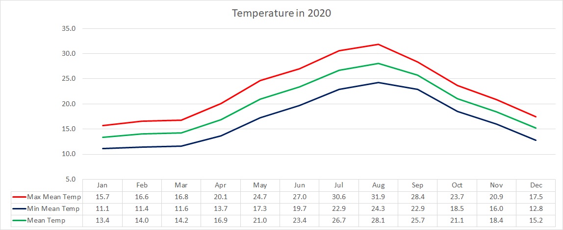
2020 was warmer than normal. With a mean temperature of 19.8˚C, the annual average was exceeded by 1.6˚C. The greatest difference from the climate mean was recorded in minimum temperatures. The months of June, July and October were the only ones with temperatures not above the norm. No month this year broke any temperature records. The hottest day in 2020 was to be 15th August, with a 35.8˚C maximum. On that same day, the mercury soared to 38˚C across central Malta. The coldest night of 2020 came in the first week of the year. The thermometer dipped to 7.3˚C on 5th January. A colder 5˚C was measured at the airport on the same night.

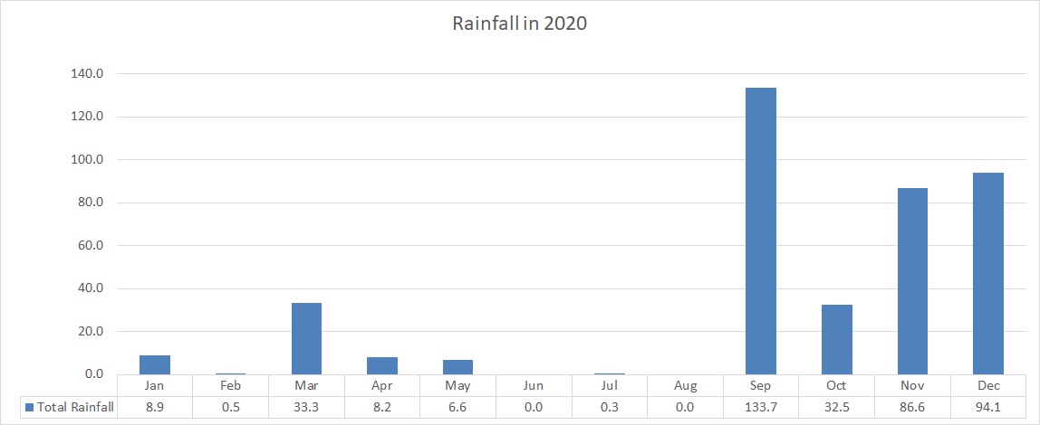
2020 was a very dry year overall. A total of 381.7 mm was measured. That is a staggering 200 mm below the climate average. January 2020 became the second driest January on record. February 2020 broke the record for the driest February ever. In fact, with just 0.5 mm of rain, it was as dry as June, July and August. By the end of June, or halfway through the year, only 57.5 mm of rain were measured. A reasonably wet autumn in the second half of 2020 eased the drought. The highest 24-hour total in 2020 was of 112.1 mm on 14th September. Much of this fell in a heavy thunderstorm that went on uninterrupted for some four hours. This value accounted for just under 30% of the year’s total rainfall. Earlier in the year, on 27th May, the central and southern stretch of Malta experienced a severe thunderstorm. There was heavy rain, large hail, damaging wind gusts and also a waterspout.

Averaging at 16.8 km/h, the wind speed conformed with the value of a typical year. A pattern worth noting was the higher frequency of windy days (Force 5 to 6), but the lower incidence of gale-force winds (Force 8 to 9). The highest gust last year was registered at 74km/h from the Northwest, during a gale on 5th February.

Overall, the average atmospheric pressure was slightly higher than the norm. The months of Janaury and February were characterised by persistent blocking anticyclones. These are areas of high pressure that remain stationary over an area for several weeks. Bringing long days of uninterrupted bright sunshine, these anticyclones were responsible for the extreme drought experienced at the start of 2020. The highest value of atmospheric pressure was recorded on the 9th of February. It reached 1034.7hPa. The lowest value of atmospheric pressure, on the other hand, was recorded on 25th March. It dropped to 995.6hPa, as an intense low pressure system traversed the central Mediterranean.

2020’s highlights were without a doubt the severe thunderstorm on 27th May and the heavy thunderstorm on 14th September.

At least two thunderstorms drenched Malta on 27th May. The second of these, which struck in afternoon, was confirmed as having been severe. It produced wind gusts of up to Force 8 (over 62 km/h), hailstones with a diameter of around 2.5 centimetres (the size of a €2 coin) and a confirmed waterspout (dissipated over the beach) close to Armier Bay. Total rainfall ranged from 6.4 mm (Birżebbuġa) to 41.2 mm (Għargħur). On the day, an upper-level low pressure system over the central Mediterranean brought relatively cold air from the Balkans over a warm central Mediterranean, creating a great deal of instability with towering cumulus and cumulonimbus clouds that sparked heavy showers and thunderstorms. The wind was very light at all levels of the troposphere, allowing the storms to build up gradually as a result of diurnal heating. Colder air in the upper levels of the atmosphere increases instability. This is because the warmer air at ground level, being lighter and more buoyant, tends to rise. This vertical movement cools the rising air, causing the moisture within to condense and form clouds.

Around mid-September, at least four main thunderstorms struck the Maltese Islands. The first came in the early afternoon of Saturday 12/09. This drenched central and southern Malta. With 67.2 mm of rain, Luqa was the wettest locality. The second thunderstorm occurred in the morning on Sunday 13/09. This affected areas further north. Nadur and Mellieħa found themselves at the centre of this storm, with rainfall values of 40 mm each. The third and most intense storm struck at noon on Monday 14/09. It packed rainfall rates of up to 167 mm / hr, gale force winds and dangerous cloud-to-ground lightning. The island of Gozo bore the brunt of it all. It had to endure nothing less than four hours of torrential rain. In the end, the localities of Għarb and Xagħra had received the most rainfall, with 112.1 mm and 102.0 mm respectively. The 112.1 mm total from Għarb is equal to 1/5 of a typical year’s rain and almost three times the typical September’s rain. The sea surface temperature around the Maltese Islands last summer peaked at 29⁰C, a full 2⁰C warmer than the average. The high sea surface temperature contributed to increased rates of evaporation, which in turn, led to an increase in humidity levels. Around that time, a short-wave upper-level low pressure system passed across our region bringing relatively cold air over a very warm sea. This created a great deal of instability. In addition to this, a greater amount of moisture was available to be advected into these thunderstorms. The end product were the thunderstorms with intense rainfall. The absence of wind aloft meant that the entire zone of instability, along with all the individual thunderstorms within it, were extremely slow-moving. This exacerbated further the amount of rainfall dumped by the storms.
 

End of Month Reports

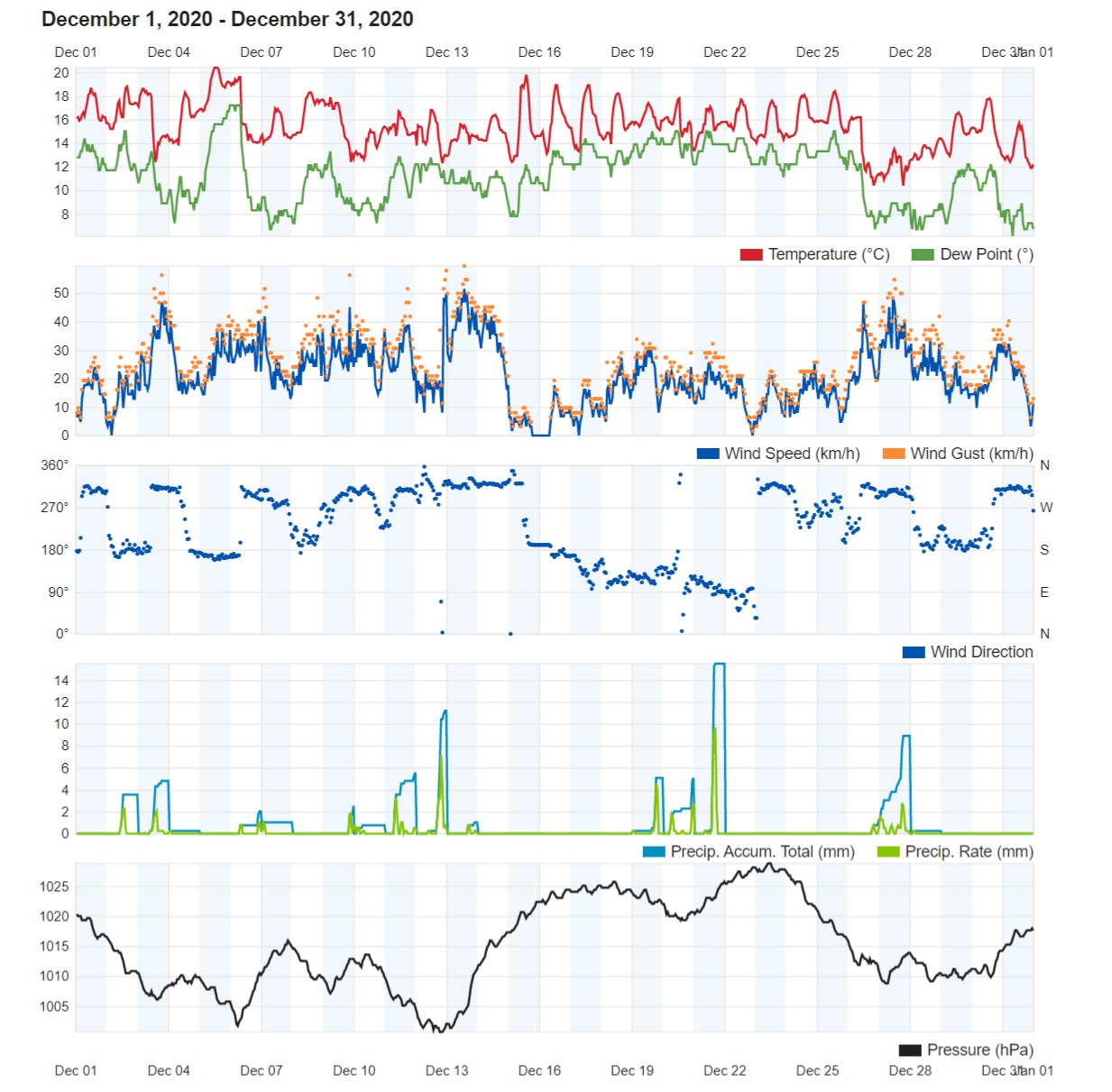
Warmer December 2020

Air Temperature

Highest Maximum 20.4°C 5th
Lowest Maximum 13.5°C 27th
Highest Minimum 16.4°C 5rh 
Lowest Minimum 9.4°C 27th


Mean Maximum 17.5°C
Mean Minimum 12.8°C
Mean 15.2°C


Relative Humidity

Highest Relative Humidity 94% Several Days
Lowest Relative Humidity 49% 7th


Mean Relative Humidity 75.8%


Atmospheric Pressure

Highest Atmospheric Pressure 1028.8hPa 23rd
Lowest Atmospheric Pressure 999.7hPa 12th


Mean Atmospheric Pressure 1014.6hPa


Wind

Highest Gust 59.5km/h 13th


Mean Wind Speed 10.5km/h
Mean Gust Speed 21.5km/h
Mean Wind + Gust Speed 16.0km/h
Most Frequent Wind Direction Southwest


Precipitation

Total Rainfall During December 2020 94.1 mm
Total Rainfall Since Last 01/09 346.9 mm


Highest 24 Hour Total 20.6 mm 21st


Rain Days 15
Thunderstorm Days 7
Hail Days 5


Rainfall Events

02/12/2020 4.7 mm Showers
03/12/2020 6.9 mm Showers; Distant Thunder
04/12/2020 0.3 mm Light Rain
06/12/2020 2.9 mm Showers; Distant Thunder; Hail
07/12/2020 1.4 mm Showers
09/12/2020 3.6 mm Light Rain; Thundery Rain/Hail Shower
10/12/2020 0.7 mm Light Rain
11/12/2020 8.0 mm Showers
12/12/2020 16.0 mm Thundery Rain/Hail Showers
13/12/2020 1.3 mm Shower
19/12/2020 6.9 mm Thunderstorm
20/12/2020 6.8 mm Showers; Distant Thunder
21/12/2020 20.6 mm Thunderstorm with Hail
26/12/2020 1.7 mm Isolated Shower
27/12/2020 12.3 mm Blustery Rain/Hail Showers


December 2020 Compared to the Climate Means

  Climate Mean December 2020 Anomaly
Mean Maximum Temperature 16.9°C 17.5°C +0.6°C
Mean Minimum Temperature 11.7°C 12.8°C +1.1°C
Mean Temperature 14.3°C 15.2°C +0.9°C
Mean Relative Humidity 79% 75.8% -3.2%
Mean Atmospheric Pressure 1017.3hPa 1014.6hPa -2.7hPa
Mean Wind Speed 18.2 km/h 16.0 km/h -2.2km/h
Most Frequent Wind Direction Northwest Southwest -45°
Total Rainfall 97.1 mm 94.1 mm -3 mm
Total Rainfall Since Last 01/09 326.1 mm 346.9 mm +20.8 mm
Total Rain Days 13 15 +2
Total Thunderstorm Days 4 7 +3
Total Hail Days 1 5 +4


Warmer December 2020

December’s air temperature peaked on the 5th, with a daytime high of 20.4°C and a nighttime low of 16.4°C. Conversely, with a daytime high of 13.5°C and a nighttime low of 9.4°C, the 27th was last month’s coolest day. The 27th was one of only two days with a minimum temperature below 10°C, as the Maltese Islands missed out on a cold snap that is normally experienced around Christmas. Overall, December 2020 was warmer than normal. The mean temperature of 15.2°C was almost a full degree above the climate mean.

The month of December 2020 maintained the trend set in the second half of November. Rain came in frequent showery episodes and was evenly distributed over the whole month. With a 24 hour total of 20.6 mm, the first day of winter (the 21st) was the wettest. A total of 94.1 mm of rain was measure in Għarb last month. This value falls just a few millimetres short of the climate average. This puts rainfall in Għarb at 346.9 mm since last September 1st, a good 20.8 mm higher than the norm. We had rain on 15 days last December. Thunder was heard on 7 of these, whilst hail accompanied the rain on 5 of these.

The month was generally calmer than the norm, maintaining a mean wind speed of 16.0 km/h rather than the expected 18.2 km/h. Whilst windy days were not lacking, the abscence of any extremely strong gales contributed to the lower mean wind speed. The wind reached Force 7 (50km/h) or stronger on 7 occasions. It reached Force 8 (62km/h) on one of these. Winds from the Southwest were characteristic of December 2020. A Southwest wind advects warm and moist air from the south across the central Mediterranean. This attributed to the significantly warmer than average temperatures experienced over the course of last month. It was also the chief cause behind the frequent showery episodes experienced. The persistent availability of warm and moist air around the Maltese Islands helped generate instability whenever cold air aloft reached our region from the north.


Rainfall Totals around the Maltese Islands in December 2020 (and since last September 1st)

Għarb – 94.1 mm (346.9 mm)

Victoria – 82.6 mm (327.4 mm)

Xewkija – 68.0 mm (261.8 mm)

Nadur – 98.4 mm (388.2 mm)

Mellieħa – 56.2 mm (211.2 mm)

Buġibba – 70.0 mm (233.3 mm)

Mġarr – 62.2 mm (208.9 mm)

Għargħur – 56.3 mm (302.3 mm)

Attard – 69.3 mm (375.8 mm)

Rabat – 67.8 mm (207.1 mm)

Msida – 81.6 mm (316.7 mm)

Valletta – 55.8 mm (200.2 mm)

Luqa – 68.2 mm (326.6 mm)

Żabbar – 85.6 mm (340.9 mm)

Birżebbuġa – 51.1 mm (237.3 mm)

End of Month Reports

The Two Faces of November 2020

Air Temperature

Highest Maximum 23.6°C 16th
Lowest Maximum 18.7°C 21st
Highest Minimum 18.3°C 16rh 
Lowest Minimum 12.9°C 29th


Mean Maximum 20.9°C
Mean Minimum 16.0°C
Mean 18.4°C


Relative Humidity

Highest Relative Humidity 93% 25th
Lowest Relative Humidity 56% 12th


Mean Relative Humidity 77.7%


Atmospheric Pressure

Highest Atmospheric Pressure 1027.8hPa 7th and 8th
Lowest Atmospheric Pressure 1006.8hPa 29th


Mean Atmospheric Pressure 1021.4hPa


Wind

Highest Gust 54.7km/h 20th


Mean Wind Speed 5.9km/h
Mean Gust Speed 12.4km/h
Mean Wind + Gust Speed 9.2km/h
Most Frequent Wind Direction West Northwest


Precipitation

Total Rainfall During November 2020 86.6 mm
Total Rainfall Since Last 01/09 252.8 mm


Highest 24 Hour Total 17.9 mm 17th


Rain Days 10
Thunderstorm Days 7
Hail Days 1


Rainfall Events

08/11/2020 0.1 mm Early Drizzle
15/11/2020 3.2 mm Morning Shower
17/11/2020 17.9 mm Thunderstorm; Period of Steady Rain
21/11/2020 13.8 mm Isolated Showers; Thunderstorm
22/11/2020 9.4 mm Light Rain; Thunderstorm with Hail
23/11/2020 6.2 mm Showers; Distant Thunder
24/11/2020 8.3 mm Showers; Distant Thunder
25/11/2020 10.8 mm Showers; Distant Thunder
26/11/2020 0.8 mm Light Rain
29/11/2020 16.1 mm Showers; Thunderstorm


November 2020 Compared to the Climate Means

  Climate Mean November 2020 Anomaly
Mean Maximum Temperature schweiz-libido.com 20.5°C 20.9°C +0.4°C
Mean Minimum Temperature 14.8°C 16.0°C +1.2°C
Mean Temperature 17.7°C 18.4°C +0.7°C
Mean Relative Humidity 77% 77.7% +0.7%
Mean Atmospheric Pressure 1017.9hPa 1021.4hPa +3.5hPa
Mean Wind Speed 16.3 km/h 9.2 km/h -7.1km/h
Most Frequent Wind Direction Northwest West Northwest -22.5°
Total Rainfall 90.1 mm 86.6 mm -3.5 mm
Total Rainfall Since Last 01/09 229.0 mm 252.8 mm +23.8 mm
Total Rain Days 11 10 -1
Total Thunderstorm Days 4 7 +3
Total Hail Days 1 1 0


The Two Faces of November 2020

The first half of November 2020 was characterized by uninterrupted warm temperatures and dry weather. This changed almost like a switch midway through. The second half of last month was dominated by rainy days and cooler temperatures. This abrupt change in meteorological conditions can be attributed to the sudden collapse of an anticyclone which had covered the central Mediterranean for weeks. This allowed cool air from the north to infiltrate our area and clash with the warm and moist air locally to generate successive zones of instability.

Overall, November 2020 turned out to be warmer than the climate norm. At 16.0°C, nights were a solid 1.2°C warmer than normal. Daytime highs on the other hand, with an 20.9°C mean, were only fractionally warmer than the norm. All days up to the 16th featured warmer than average temperatures. From then on, most days recorded temperatures cooler than the norm. Air temperatures ranged from the coolest of 12.9°C (on the 29th) to the warmest of 23.6°C (on the 16th).

It has to be said that a wet second half of the month saved an otherwise bone dry November 2020. All of the 86.6 mm of rain measured in Għarb last month fell during the last two weeks. The rain was spread over 10 days, with the wettest being the 17th, when 17.9 mm of rain were measured by our rain gauge in Għarb. Thunder was heard on 7 of these. Hail was observed once. Rainfall during the month of November 2020 conformed with the climate norm. This eased the fears of drought created by the lack of rain in October.

A notable observation was the significantly higher than average atmospheric pressure. Mean atmospheric pressure was at a staggering 1021.4hPa. The probable cause of this was the lack of cyclonic activity across the central Mediterranean. Much of the instability was the result of local instability. The stable atmosphere was reflected by the lack of windy days. In fact, the wind reached Force 6 or stronger on just 5 days. It reached Force 7 on just 2 of these. That is a stark contrast from a typical November. November is usually synonymous with the start of gales.


Rainfall Totals around the Maltese Islands in November 2020 (and since last September 1st)

Għarb – 86.6 mm (252.8 mm)

Victoria – 94.7 mm (244.8 mm)

Xewkija – 79.0 mm (193.8 mm)

Nadur – 121.9 mm (289.8 mm)

Mellieħa – 40.6 mm (155.0 mm)

Buġibba – 53.0 mm (163.3 mm)

Mġarr – 57.6 mm (146.7 mm)

Għargħur – 88.0 mm (246.0 mm)

Attard – 72.0 mm (306.5 mm)

Rabat – 54.1 mm (139.3 mm)

Msida – 59.7 mm (235.1 mm)

Valletta – 42.8 mm (144.4 mm)

Luqa – 86.4 mm (258.4 mm)

Żabbar – 79.5 mm (255.3 mm)

Birżebbuġa – 78.9 mm (186.2 mm)

End of Month Reports

A Marginally Cooler but Significantly Drier October 2020

Air Temperature

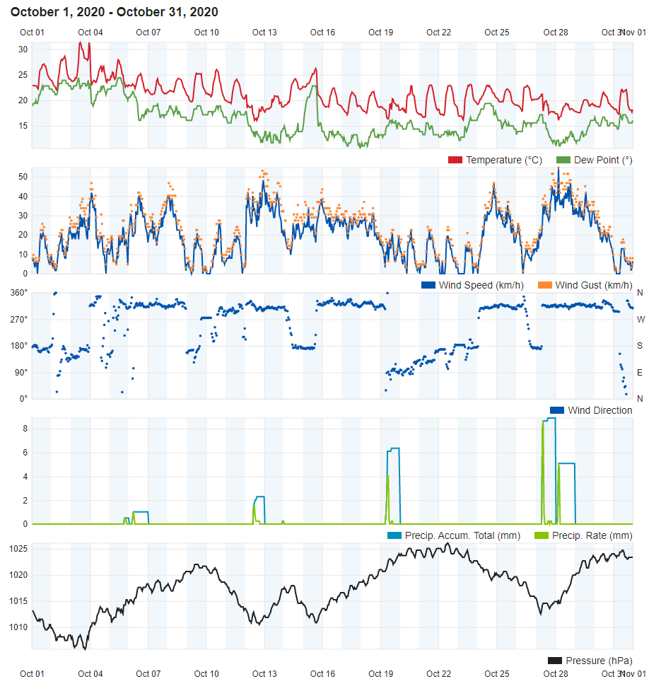
Highest Maximum 31.3°C 3rd
Lowest Maximum 19.4°C 28th
Highest Minimum 23.4°C 3rd 
Lowest Minimum 13.5°C 28th


Mean Maximum 23.7°C
Mean Minimum 18.5°C
Mean 21.1°C


Relative Humidity

Highest Relative Humidity 93% Several Days
Lowest Relative Humidity 44% 6th


Mean Relative Humidity 72.4%


Atmospheric Pressure

Highest Atmospheric Pressure 1026.1hPa 22nd
Lowest Atmospheric Pressure 1005.8hPa 3rd


Mean Atmospheric Pressure 1017.4hPa


Wind

Highest Gust 54.7km/h 28th


Mean Wind Speed 11.0km/h
Mean Gust Speed 19.6km/h
Mean Wind + Gust Speed 15.3km/h
Most Frequent Wind Direction West Southwest


Precipitation

Total Rainfall During October 2020 32.5 mm
Total Rainfall Since Last 01/09 166.2 mm


Highest 24 Hour Total 12.3 mm 27th


Rain Days 7
Thunderstorm Days 3
Hail Days 0


October 2020 Compared to the Climate Means

  Climate Mean October 2020 Anomaly
Mean Maximum Temperature 24.5°C 23.7°C -0.8°C
Mean Minimum Temperature 18.2°C 18.5°C +0.3°C
Mean Temperature 21.4°C 21.1°C -0.3°C
Mean Relative Humidity 78% 72.4% -5.6%
Mean Atmospheric Pressure 1017.6hPa 1017.4hPa -0.2hPa
Mean Wind Speed 14.1 km/h 15.3 km/h +1.2km/h
Most Frequent Wind Direction Northwest West Southwest -67.5°
Total Rainfall 89.0 mm 32.5 mm -56.5 mm
Total Rainfall Since Last 01/09 138.9 mm 166.2 mm +27.3 mm
Total Rain Days 9 7 -2
Total Thunderstorm Days 5 3 -2
Total Hail Days 1 0 -1


A Marginally Cooler but Significantly Drier October 2020

Overall, October 2020 turned out to be marginally cooler than the climate norm. At 23.7°C, daytime highs were almost a solid 0.8°C cooler than normal. Nights on the other hand, with an 18.5°C mean, were slightly warmer. Last month started off on a very warm note. It was the third October in the past decade to record a maximum temperature of over 30°C. This was on the 3rd, when the mercury shot up to 31.3°C. The transition to the cool season gained strong momentum during the second half of the month. Successive pockets of cooler air from over Europe meant a good number of days with cooler than average temperatures. A 13.5°C low, the coldest for October 2020, was registered on the 29th. This was accompanied by rain and strong winds brought about by a sharp cold front.

In a stark contrast to the previous month, October 2020 was very dry. The 32.5 mm of rain accumulated over the course of this month accounted for much less than half of October’s climate average. This was the result of anticyclonic conditions that prevailed over the central Mediterranean. These acted as a barrier, which weakened storms as soon as they reached the Maltese Islands. The 7 days of rain and 3 days of thunder observed last month were less than the norm for this time of year. October is renowned locally for being the stormiest month of the year. This year was different, as no severe rainfall events were experienced.

The average wind speed of 15.3 km/h almost confirmed with the climate mean. Winds from the West Southwest were more dominant. Two near gales (Force 7 winds) swept the Maltese Islands in October 2020, on the 12th / 13th and 27th / 28th.

Rainfall Totals around the Maltese Islands in October 2020

Għarb – 32.5 mm

Victoria – 26.3 mm

Xewkija – 26.4 mm

Nadur – 44.4 mm

Mellieħa – 33.0 mm

Buġibba – 36.3 mm

Mġarr – 23.1 mm

Għargħur – 51.5 mm

Attard – 61.7 mm

Rabat – 31.4 mm

Msida – 41.0 mm

Valletta – 20.0 mm

Luqa – 28.4 mm

Żabbar – 33.0 mm

Birżebbuġa – 34.0 mm

End of Month Reports

Hotter September 2020

Air Temperature

Highest Maximum 32.1°C 10th
Lowest Maximum 24.3°C 26th
Highest Minimum 24.8°C 4th 
Lowest Minimum 19.4°C 14th


Mean Maximum 28.4°C
Mean Minimum 22.9°C
Mean 25.7°C


Relative Humidity

Highest Relative Humidity 95% 14th
Lowest Relative Humidity 45% 26th


Mean Relative Humidity 74.7%


Atmospheric Pressure

Highest Atmospheric Pressure 1023.4hPa 4th
Lowest Atmospheric Pressure 1005.1hPa 27th


Mean Atmospheric Pressure 1015.7hPa


Wind

Highest Gust 61.2km/h 26th


Mean Wind Speed 8.5km/h
Mean Gust Speed 16.7km/h
Mean Wind + Gust Speed 12.6km/h
Most Frequent Wind Direction Northwest


Precipitation

Total Rainfall During September 2020 133.7 mm
Total Rainfall Since Last 01/09 133.7 mm


Highest 24 Hour Total 112.1 mm 14th


Rain Days 8
Thunderstorm Days 1
Hail Days 6


September 2020 Compared to the Climate Means

  Climate Mean September 2020 Anomaly
Mean Maximum Temperature 28.1°C 28.4°C +0.3°C
Mean Minimum Temperature 21.1°C 22.9°C +1.8°C
Mean Temperature 24.6°C 25.7°C +1.1°C
Mean Relative Humidity 77% 74.7% -2.3%
Mean Atmospheric Pressure 1017.4hPa 1015.7hPa -1.7hPa
Mean Wind Speed 13.7 km/h 12.6 km/h -1.1km/h
Most Frequent Wind Direction Northwest Northwest
Total Rainfall 49.9 mm 133.7 mm +83.8 mm
Total Rainfall Since Last 01/09 49.9 mm 133.7 mm +83.8 mm
Total Rain Days 4 8 +4
Total Thunderstorm Days 3 6 +3
Total Hail Days 1 1 0


Hotter September 2020

A hotter than average September brought summer 2020 to an end. With a mean temperature of 25.7°C, September 2020 was 1.1°C warmer than the climate norm. Nights were particularly warm. The mean minimum temperature of 22.9°C exceeded the climate mean by a staggering 1.8°C. Temperatures dropped to below average on only two occasions. These were the 13th and 14th, thanks to widespread thunderstorms. A cold front which swept Europe at the end of the month also reached the Maltese Islands. This ensured a cool final five days.

September 2020 produced 133.7 mm of precipitation at our weather station in Għarb. That is just under three times the amount in a typical September. 83% of this fell in just a few hours, during a torrential thunderstorm in the afternoon of the 14th. There were 8 days of rain in total last month. Thunder was heard on 6 of these. Some hail was observed on 1 of these, the 14th. Of the 8 rainy days, 6 had a total rainfall of 2.5 mm or less. Statistically, September 2020 was much wetter than normal when compared to the climate average. When you dig into the numbers, however, you’ll see that much of the rain fell in one or two heavy rainfall events halfway through the month.

September 2020 was not as windy. The wind reached Force 7 on only four days. The highest wind gust of 61.2 km/h (from the Northwest) was measured on the 26th. 17 of 30 days were characterised by a wind speed of Force 2 (light breeze).

Rainfall Totals around the Maltese Islands in September 2020

Għarb – 133.7 mm

Victoria – 123.7 mm

Xewkija – 88.4 mm

Nadur – 123.5 mm

Mellieħa – 79.4 mm

Buġibba – 74.0 mm

Mġarr – 66.0 mm

Għargħur – 106.0 mm

Attard – 172.8 mm

Rabat – 53.8 mm

Msida – 134.4 mm

Valletta – 81.6 mm

Luqa – 143.4 mm

Żabbar – 142.8 mm

Birżebbuġa – 73.0 mm

Severe Weather Reports

Heavy Thunderstorms on 12,13,14&16/09/2020

The sea surface temperature around the Maltese Islands this summer peaked at 29⁰C, a full 2⁰C warmer than the average. The high sea surface temperature contributed to increased rates of evaporation, which in turn, lead to an increase in humidity levels. From 12/09 through to 16/09, a series of heavy thunderstorms occurred around the central Mediterranean. A short-wave upper-level low pressure system passed across our region bringing relatively cold air over a very warm sea, creating a great deal of instability. In addition to this, a greater amount of moisture was available to be advected into these thunderstorms. The end product were thunderstorms with intense rainfall.

Most thunderstorms were localised, affecting a few localities at a time. At least four main thunderstorms affected the Maltese Islands. The first came in the early afternoon of Saturday 12/09. This drenched central and southern Malta. With 67.2 mm of rain, Luqa was the wettest locality. The second thunderstorm occurred in the morning on Sunday 13/09. This affected areas further north. Nadur and Mellieħa found themselves at the centre of this storm, with rainfall values of 40 mm each. The third and most intense storm struck at noon on Monday 14/09. It packed rainfall rates of up to 167 mm / hr, gale force winds and dangerous cloud-to-ground lightning. The island of Gozo bore the brunt of it all. It had to endure nothing less than four hours of torrential rain. In the end, the localities of Għarb and Xagħra had received the most rainfall, with 112.1 mm and 102.0 mm respectively. The 112.1 mm total from Għarb is equal to 1/5 of a typical year’s rain and almost three times the typical September’s rain. Some areas around Malta experienced the third thunderstorm too, with hardest-hit Attard recording 68.5 mm of rainfall. A final thunderstorm formed in the evening of Wednesday 16/09 and swept across parts of the Maltese Islands, affecting central and southern particularly intensely clique neste link. 37.0 mm of rain were measured in Msida. In addition to the four main storms, a number of showers and isolated thunderstorms also affected the islands. The absence of wind at the upper levels of the atmosphere meant that the entire zone of instability, along with all the individual thunderstorms within it were extremely slow-moving. This exacerbated further the amount of rainfall dumped by the storms. Below are values for total rainfall gathered in several localities around the Maltese Islands:

Għarb – 129.9 mm

Victoria – 121.1 mm

Nadur – 117.0 mm

Xewkija – 84.6 mm

Mellieħa – 68.4 mm

Buġibba – 63.3 mm

Mġarr – 44.1 mm

Attard – 132.8 mm

Għargħur – 80.5 mm

Msida – 123.4 mm

Rabat – 40.3 mm

Valletta – 77.8 mm

Luqa – 134.7 mm

Żabbar – 136.7 mm

Birżebbuġa – 70.6 mm

Thanks to these thunderstorms, the total rainfall all round the Maltese Islands for September 2020 is already higher than the climate average for the same month.

A series of waterspouts were observed, particularly on Sunday. These start their existence as a funnel cloud below a cumuliform cloud when a column of swirling air begins to rotate, causing the surrounding moisture to condense into water droplets. This vortex begins to move downward, creating a funnel shape which protrudes for a distance below the cloud. Often, it is too weak to extend all the way down and make contact with the ground. When it does manage contact with the ground, it takes the form of a weak waterspout or landspout. Most funnels which form locally are of this kind, and rarely of their stronger relatives, the tornadoes.