Updates

For the latest updates related to the weather in the Maltese Islands. So keep yourself updated by visiting this page frequently or like our Facebook page.

Updates

Why is the weather still unstable? / Għalfejn għadu nstabbli t-temp?

ENGLISH/INGLIŻ

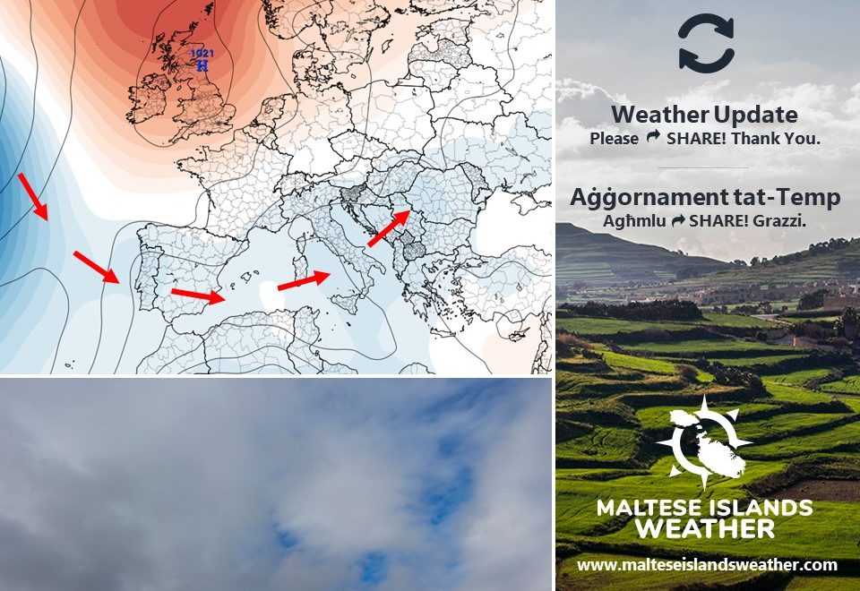
June’s here, but the weather is not quite as settled yet. We’re experiencing frequent strong winds, cooler than average temperatures and days with grey skies (and the odd rain shower). This is the result of an anticyclone spanning the British Isles and Scandinavia, coupled with unseasonal zones of low pressure across the central Mediterranean. This meteorological setting deviates zones of instability which originate over the Atlantic to the south, away from northern Europe and towards the Mediterranean region (as shown by the arrows). The sea, which is now much warmer, charges these zone of instability with moisture. As a result, cloudy skies develop. The spatial differences in atmospheric pressure which arise from these systems generate breezy winds. Finally, being of north Atlantic origin, these zones of instability drag cooler air masses with them, causing the many spells of cooler than average temperatures. The anticyclone over the British Isles and Scandinavia will weaken. Meanwhile, the anticyclone which expands to cover the Mediterranean region every summer will strengthen steadily, ensuring the gradual arrival of proper summer weather in the coming weeks.


MALTI / MALTESE

Ġunju wasal imma t-temp bħal donnu għadu ma jridx jissoda. Spiss qed nesperjenzaw riħ qawwi, temperaturi f’livelli anqas mill-medja u xi jiem griżi (b’xi ħalba xita iżolata). Dan it-temp huwa riżultat ta’ antiċiklun mifrux fuq il-Gżejjer Brittaniċi u l-Iskandinavja, flimkien ma’ żoni ta’ pressjoni baxxa mhux staġġjonali madwar iċ-ċentru tal-Mediterran. Din is-sitwazzjoni meterjoloġika twassal biex żoni nstabbli li jorriġinaw fuq l-Atlantiku jiġu mbuttati lejn ir-reġjun tal-Mediterran, lil hinn mit-tramuntana ta’ l-Ewropa (kif indikat mill-vleġġeġ). Dawn iż-żoni ta’ instabbilita’ jiġbru ħafna fwar minn fuq il-baħar ta’ madwarna li issa beda jisħon sew. Riżultat ta’ dan, jifforma aktar sħab. Id-differenza fil-pressjoni atmosferika li tinħoloq kaġun ta’ din l-instabbilita’ ta’ spiss toħloq riħ qawwi. Fl-aħħar minn l-aħħar, dawn iż-żoni nstabbli jġibu magħhom arja aktar friska minn naħa ta’ fuq ta’ l-Ewropa u b’hekk kultant ibaxxu t-temperaturi għal livelli taħt il-medja. L-antiċiklun fuq il-Gżejjer Brittaniċi u l-Iskandinavja se jidgħajjef. Sadattant, l-antiċiklun li ssoltu jespandi u jgħatti r-reġjun tal-Mediterran matul is-sajf se jissaħħaħ bilmod, u b’hekk jimmarka l-wasla gradwali ta’ temp propja sajf matul il-ġimgħat li ġejjin.

Updates

This week: Midweek instability

June will be off to a slightly unstable start. A low pressure system of north African origin should bring grey skies, a strong easterly wind and haze to the central Mediterranean around midweek. A little dusty rain is possible too, particularly on Wednesday 2/6. The remaining days are likely to be characterized by largely settled weather conditions. With the exception of Wednesday 2/6 and Thursday 3/6, we’re expecting winds to be mainly light and from regularly alternating directions schweiz-libido.com. Temperatures will be colder than average over the first half of this week, before warming up over the weekend. Daytime highs will vary from 24°C to 29°C. Nighttime lows will be more stable, hovering in the range of 17°C to 20°C.

Updates

This week: Becoming warmer and calmer

This week’s weather will be a step closer to summer. Temperatures will be warmer and stable. Daytime highs will be at 27°C/28°C. Nighttime lows, on the other hand, will hover at 18°C/19°C. The wind will be appreciably lighter, with only Monday 24/5 bringing a brief episode of strong wind libido-de.com/. The wind should not exceed Force 4 on remaining days. Wind direction will vary widely. Most days will be characterized by sunny or mainly sunny skies. Having said that, a few moments of cloudier skies cannot be completely ruled out. Another parameter worth mentioning is sea surface temperature. This will rise to 20°C now.

Updates

This week: At least two windy days

Strong winds will prevail on some days this week, but the situation is clearly stabilizing as spring slowly progresses into summer. Most days this week will enjoy mainly sunny to partly cloudy skies. As one would expect, the chance of rain will be close to negligible. We’re expecting temperatures to vary fairly widely, especially where daytime highs are concerned. We’re looking at values in the range of 24°C to 29°C. Days with a breezy wind will be the cooler ones. Calmer days will obviously be warmer. Nighttime lows will be more uniform, hovering at 16°C to 18°C. A breezy northwesterly wind is likely around midweek. The remaining days will be characterized by a lighter wind, from the Northwest at first, before shifting South towards the week’s end. No fine dust is expected.

Updates

This week: Plenty of sunshine on most days

The weather across the Maltese Islands this week will be the result of successive zones of high pressure to the east, and persistent low pressure to the west. We’re in for a breezy week, with wind speeds likely to reach at least Force 5 at some point on all seven days. The wind this week will alternate between the Southeast and Northwest. There’s likely to be at least one day of grey skies this week. Chances are this will coincide with the weekend. The remaining days will enjoy mainly sunny or partly cloudy skies. Temperatures will hover at levels which are slightly cooler than average for this time of year. We’re expecting daytime highs in the range of 22°C to 25°C. Nighttime lows will vary between 15°C and 18°C.

Updates

This week: A few more grey days

Cut-off lows from north Africa will continue to traverse the central Mediterranean this week. These will maintain a current of very warm air across the region. Consequently, temperatures will remain stable, with 25°C + daytime highs and 16°C + nighttime lows. These temperature values are above average for this time of year. Needless to say, the sustained movement of north African lows across the central Mediterranean will mean winds from the Southeast to Northeast are likely to persist. Whilst most days will feature a light to moderate wind, a windy episode is possible, particularly on Thursday 6/5 or Friday 7/5. Once again, it is important to keep in mind that the warm temperatures and lighter winds don’t mean that days of grey skies are behind us. In fact, it’s  likely that two to three days this week will feature grey skies. The remaining days will be brighter. We may also get a drop of light rain on grey days too. Mist or fog patches may also develop on calm nights.

Updates

3 Hourly Forecast for Workers’ Day (01/05/2021)

00:00 to 03:00 -cloudy; 17°C / 18°C; East Force 3 to 4
03:00 to 06:00 – cloudy; 17°C / 18°C; East to East Northeast Force 3 to 4
06:00 to 09:00 – cloudy; 17°C / 18°C to 21°C; East Northeast Force 4 to 5
09:00 to 12:00 – cloudy; 21°C to 24°C / 25°C; East Northeast Force 4 to 5
12:00 to 15:00 – cloudy; 24°C / 25°C; East Northeast Force 4 to 5
15:00 to 18:00 – cloudy; 24°C / 25°C; Northwest Force 3 to 4
18:00 to 21:00 – cloudy; 24°C / 25°C to 21°C; Northwest Force 3 to 4
21:00 to 00:00 – cloudy; 21°C to 19°C; Northwest Force 3 to 4

Workers’ Day (or Labour Day) is an annual holiday celebrated all over the world, recognizing the economic and social achievements of workers. Popularly known as May Day or International Workers’ Day, the 1st of May is also a public holiday in Malta and Gozo. It also marks the legal establishment of the eight-hour working day. The date also coincides with the religious feast of St. Joseph the Worker celebrated in the town of Birkirkara. It is also 17 years since Malta joined the European Union.

Updates

This week: Temperatures going up

A plume of very warm air from north Africa will extend towards the central Mediterranean. It will cover the Maltese Islands for much of this week. Temperatures will be substantially warmer. With a daytime high of 21°C and nighttime low of 13°C, Monday 26/4 will be this week’s coldest days https://southafrica-ed.com/kamagra-in-south-africa/. From Tuesday 27/4 onward, we expect maximum temperatures to reach 25°C + on all days. Nighttime lows should not dip below 16°C. The wind will be noticeably lighter too, with Monday 26/4 likely to bring this week’s only windy episode. The wind from the Southeast should reach gusts of up to Force 8 then. The rest of the week should be characterized by a light wind. The easterlies will continue to dominate. The warmer temperatures and lighter winds do not mean we’re done with the grey skies just yet, though. In fact, the latest weather maps suggest that two to three days this week will feature grey skies. The remaining days will be brighter. We may also get a drop of light rain on grey days too.

Updates

Temperatures and UV Index to rise / It-temperaturi u l-Indiċi UV se jogħlew

ENGLISH/INGLIŻ

Much warmer weather is on the cards for the Maltese Islands, as the recent colder than average temperatures come to an end with the arrival of warmer air from over the desert. By midweek, we expect temperatures to start reaching daytime highs of 25°C (and warmer) frequently. Nights will obviously become warmer too, with minimum temperatures not likely to continue dipping to below 15°C after midweek. The rise in temperatures does not automatically mean day-in day-out of uninterrupted bright sunshine. The southeasterly wind, which is forecast to prevail for now, is likely to continue bringing some more grey sky days. The UV Index will climb higher in the scale too. As of this weekend it will start reaching Level 9. This is considered to be ‘Very High’. A UV index reading of 8 to 10 indicates a very high risk of harm from unprotected exposure to the Sun. You should take extra precautions because unprotected skin and eyes will be damaged and could burn quickly. It is advised that you minimize exposure to the sun between 10 a.m. and 4 p.m. If extremely essential to be outdoors; seek shade and wear Sun protective clothing. These include a wide-brimmed hat, UV-blocking sunglasses and SPF 30+ sunscreen. Bright surfaces, such as sand and water, will increase UV exposure. All in all, we’re certain that the transition to summer is at an advanced stage now!

A frequently asked question: “Are we done with the dusty rain?” Our answer: “There’s still some more to go, but they will obviously become less frequent as the weeks progress.”


MALTI / MALTESE

Qed nantiċipaw li l-Gżejjer Maltin se jibdew igawdu minn temp aktar sħun, hekk kif l-episodju ta’ arja aktar kiesħa mill-medja ta’ l-aħħar ġimgħat se jkun qed jiġi fi tmiemu bil-wasla ta’ arja aktar sħuna minn fuq id-deżert. Nistennew li minn nofs il-ġimgħa li ġejja, it-temperaturi massimi se jibdew jilħqu l-livell ta’25°C (u ogħla) aktar ta’ spiss. L-iljieli wkoll se jkunu aktar sħan, bl-anqas temperaturi mhux mistennija jibqgħu jaqgħu taħt 15°C minn nofs il-ġimgħa li ġejja. Din il-bidla fit-temperaturi mhux se tfisser it-tmiem ta’ ġranet b’ajru ċlampu pero’. Ir-riħ mix-Xlokk li għandu jkompli jippersisti għalissa, xorta se jkompli jġib miegħu jiem iddominati minn temp griż. L-Indiċi UV ukoll se jibda tiela. Minn dawn il-jiem, din se tkun qed tlħaq livell 9. Din hija kkunsidrata ‘Għolja Ħafna’. Indiċi UV minn 8 sa 10 tindika riskju għoli ħafna ta’ ħsara minn espożizzjoni diretta għax-xemx. Għandek tieħu prekawzzjonijiet addizzjonali biex tevita ħsara lil ġilda u għajnejn. Jekk inhu possibbli, naqqas il-ħin li tqatta fix-xemx bejn 10 a.m. u 4 p.m. Jekk ma tistax tagħmel mod ieħor; fittex li toqgħod fid-dell kull x’ħin tista u ara li tilbes ilbies li joffri protezzjoni mix-xemx. Dawn jinkludu beritta/kappell, nuċċali tax-xemx li jilqa għal UV kif ukoll li tuża sunscreen SPF 30+. Uċuħ jgħajjtu bħal ramel u ilma iżidu l-qawwi ta’ l-UV.

Il-mistoqsija ta’ bħalissa: “Lesti mix-xita tal-ħamrija?” It-tweġiba tagħna: “Għad fadal ftit x’jagħmel, imma ovvjament, kull ma jmur se tnaqqas fil-frekwenza tagħha.”


Updates

This week: Possible return of consistent 20°C temperatures

More instability is likely to affect the central Mediterranean over the coming week, as high pressure shows no sign of taking over just yet. We expect this week to be characterized by at least a few days of grey skies, and possibly also some haze due to airborne fine desert sand. Some days will be brighter, however. Some light rain may fall on or two days as well. For yet another week, it’s very likely that we’ll experience a couple of windy days. Whilst the week will start off with a strong breeze from the Northwest, the second half of the week should bring a few days of strong wind from the East. With the exception of the first one or two days, the easterly wind will be dominant this week. Temperatures will present a more convincing hint of spring, however, as daytime highs start reaching 20°C more frequently from this week. Nights will also warm up, with minimum temperatures likely to be around the 14°C / 15°C from midweek onward.