Updates

For the latest updates related to the weather in the Maltese Islands. So keep yourself updated by visiting this page frequently or like our Facebook page.

Updates

GALE-FORCE WIND WARNING / TWISSIJA TA’ RIEFNU

ENGLISH/INGLIŻ

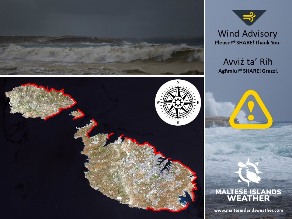
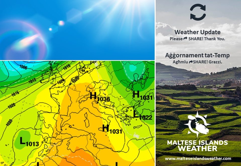
An intense low pressure system emerging from north Africa will move into the Gulf of Gabes on Friday 16th April. Air from high pressure over the Sahara Desert will rush in to fill this low pressure system https://polska-ed.com/kupic-generic-cialis/. This rushing air will generate a gale-force Scirocco. This warning is valid from 00:00 till 21:00 on Friday 16th April. The warning will be updated when and if necessary. The information below describe how the situation will develop over this time period.


Friday 16th April

00:00 to 03:00 – East Force 5 to 6

03:00 to 06:00 – East Force 6 to 7

06:00 to 09:00 – East Force 7 to 8

09:00 to 12:00 – East Force 7 to 8 (with gusts of up to Force 9)

12:00 to 15:00 –  East Force 7 to 8

15:00 to 18:00 – East to East Northeast Force 6 to 7

18:00 to 21:00 – East Northeast 5 to 6


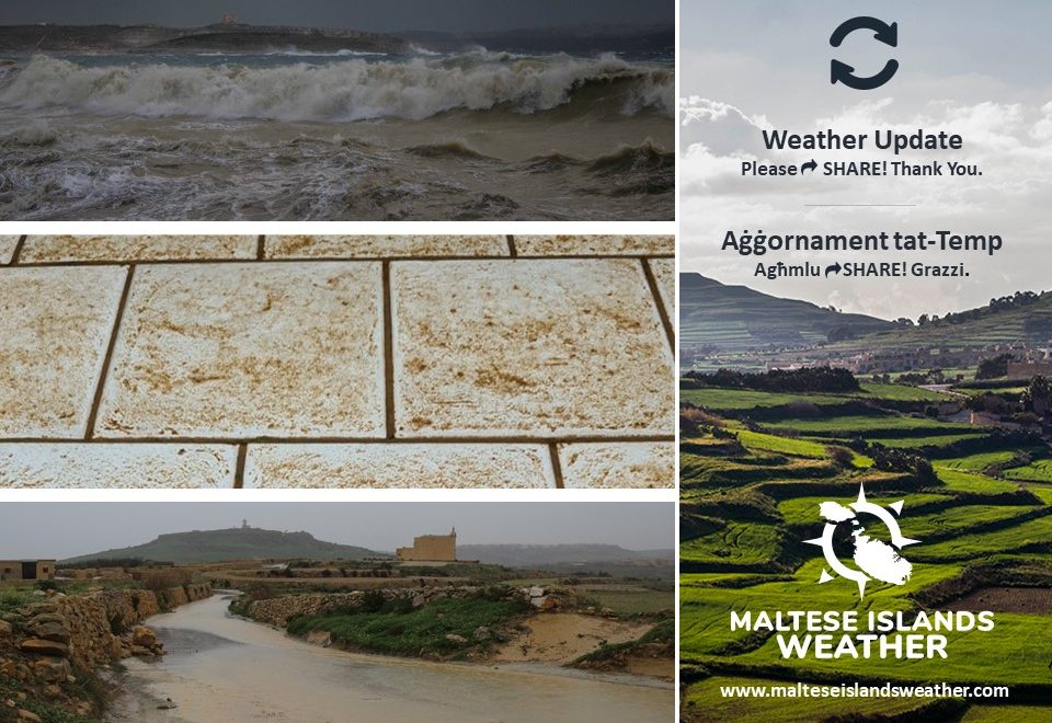
The peak gusts will blow across the Maltese Islands in the morning, when they could reach Force 9 at times across exposed areas of the Maltese Islands. The sea will be very rough, with wave heights of up to 6 metres in peak gusts. The swell will be a low to moderate East, especially in the second half of the day. The map indicates the coast most exposed to this gale-force wind and very rough sea. Airborne fine desert sand will be present in abundance.

The wind will decline gradually to become mainly moderate (Force 4 to 5) by morning on Saturday 17th April, before shifting Northwest.


MALTI / MALTESE

Sistema ta’ pressjoni baxxa intensa minn l-Afrika ta’ fuq se tersaq fuq il-Golf ta’ Gabes nhar il-Ġimgħa 16 ta’ April. Arja minn pressjoni għolja fuq id-Deżert tas-Saħara se timla din is-sistema ta’ pressjoni baxxa bilmod u timmanifesta ruħha bħala riefnu mix-Xlokk. Din it-twissija se tkun fis-seħħ minn 00:00 sa 21:00 ta’ nhar il-Ġimgħa 16 ta’ April u se tkun aġġornata kif u jekk ikun meħtieġ. L-informazzjoni ta’ hawn isfel tindika kif se tiżviluppa s-sitwazzjoni mal-ħin.


Il-Ġimgħa 16 ta’ April

00:00 sa 03:00 – Lvant Forza 5 għal 6

03:00 sa 06:00 – Lvant Forza 6 għal 7

06:00 sa 09:00 – Lvant Forza 7 għal 8

09:00 sa 12:00 – Lvant Forza 7 għal 8 (b’buffuri sa Forza 9)

12:00 sa 15:00 –  Lvant Forza 7 għal 8

15:00 sa 18:00 – Lvant għal Grieg il-Lvant Forza 6 għal 7

18:00 sa 21:00 – Grieg il-Lvant Forza 5 għal 6


Il-buffuri l-aktar qawwija se jolqtu l-Gżejjer Maltin matul filgħodu, meta jistgħu jlaħħqu sa Forza 9 fl-inħawi l-aktar esposti tal-Gżejjer Maltin. Il-baħar se jkun qawwi b’mewġ għoli 6 metri fil-buffuri l-aktar qawwija. L-imbatt se jkun baxx għal-moderat mill-Lvant, speċjalment fit-tieni nofs tal-jum. Il-mappa ta’ hawn taħt tindika l-kosta l-aktar esposta għal dan ir-riefnu u baħar imqalleb ħafna. Se jkun hemm preżenza abbundanti ta’ trab fin fl-arja.

Ir-riħ se jonqos gradwalment u jsir il-biċċa l-kbira moderat (Forza 4 għal 5) sa filgħodu tas-Sibt 17 ta’ April, qabel ma jaqleb Majjistral.

Updates

Stormy weather ahead / Ġej il-maltemp

ENGLISH/INGLIŻ

An intense low pressure system of north African origin will traverse the central Mediterranean over the next few days, bringing an episode of stormy weather to the Maltese Islands. Starting from early on Thursday 15/4, and lasting for up to five days, the Maltese Islands will see strong winds, rain and also airborne desert sand. This update gives a general overview of how the situation will unfold. More specific updates, and were necessary warnings, will be posted accordingly as the stormy spell progresses.

Strong Wind: The wind from the East will reach up to Force 8 (possibly gusting up to Force 9) on Friday 16/4, with the latest models predicting that the wind will be at its strongest during the morning and early afternoon. A shift in wind direction to the Northwest is likely over the weekend. Another episode of strong wind is possible on Monday 19/4, with current maps indicating the possibility of a Force 7 wind from the Northwest on that day.

Airborne Desert Sand and Rain: We’re expecting the coming days to be characterized by increased cloudiness. Thursday 15/4 and Friday 16/4 should feature an overcast sky along with hazy air (due to airborne desert sand), weather conditions synonymous with low pressure systems of north African origin. Patchy light rain is possible on both days, with any rain certainly depositing copious amounts of desert sand. The levels of airborne desert sand will decline as the weekend progresses, due to a shift in the wind direction. A clash between cold air from the north and warm air from the south will occur over the central Mediterranean late on Sunday 18/4. Some rain is almost guaranteed then. Depending on where the two meet, the Maltese Islands may get anything from a few isolated showers to a downpour. This will be confirmed closer to the date. Heavier rain will naturally be cleaner.

We’re looking at daytime highs in the region of 17°C / 18°C on these days. Nighttime lows will be at the level of 12°C / 13°C. Both are cooler than average for this time of year https://southafrica-ed.com/kamagra-in-south-africa/.


MALTI / MALTESE

Sistema ta’ pressjoni baxxa intensa li se tizviluppa lejn in-naħa ta’ fuq ta’ l-Afrika u li se tgħaddi minn fuq iċ-ċentru tal-Mediterran fil-jiem li ġejjin, se twassal għal perjodu ta’ maltemp ġewwa l-Gżejjer Maltin. Jibda minn kmieni l-Ħamis 15/4, u jkompli għal minn ta’ l-anqas ħamest ijiem, il-Gżejjer Maltin se jesperjenzaw riħ qawwi, xita u anke trab fin fl-arja. Dan l-aġġornament jagħti indikazzjoni ħafifa ta’ kif se tiżvolġi s-sitwazzjoni matul dawn il-jiem. Aġġornamenti aktar dettaljait jingħataw mal-ħin u kif ikun meħtieġ.

Riħ Qawwi: Ir-riħ mill-Lvant se jilħaq sa Forza 8 (b’buffuri possibilment jilħqu Forza 9) nhar il-Ġimgħa 16/4, bl-aħħar mapep tat-temp jindikaw li r-riħ se jkun l-aktar qawwi matul filgħodu u kmieni wara nofsinhar. Qalba fir-riħ lejn il-Majjistral imbassra li sseħħ matul tmiem il-ġimgħa. Episodju ieħor ta’ riħ huwa possibli nhar it-Tnejn 19/4, bil-mapep kurrenti jsostnu l-possibilita ta’ riħ sa Forza 7 mill-Majjistral matul dak il-jum.

Trab Fin fl-Arja u Xita: Qed nistennew li l-jiem li ġejjin ikunu ddominati minn sema aktar imsaħħab. Nhar il-Ħamis 15/4 u l-Ġimgħa 16/4 għandhom ikunu kkaratteriżżati minn sema ċlampu u arja mdaħħna (minħabba trab fin fl-arja), kundizzjonijiet tat-temp sinonimi ma’ sistemi ta’ pressjoni baxxa b’oriġini Afrikani. Jaf tagħmel xi xita ħafifa matul dawn il-jiem. F’dak il-każ, ix-xita tkun tal-ħamrija. L-ammont ta’ trabe fin fl-arja se jonqos matul tmiem il-ġimgħa, hekk kif ir-riħ idur. Jidher ukoll li massa ta’ arja kiesħa mit-tramuntana se tiltaqgħa ma’ arja sħunn minn fuq id-deżert sewwa sew fuq iċ-ċentru tal-Mediterran tard nhar il-Ħadd 18/4. Minħabba dan, għandna garanzija ta’ xi ftit xita dakinhar. Tagħmilx biss ħalba xita iżolata jew inkella episodju ta’ xita aktar qawwija u mifruxa jiddependi fuq fejn jiltaqgħu dawn il-masses ta’ arja kuntrastanti. Dan ikun ikkonfermat kif toqrob aktar il-ġurnata. Naturalment, xita qawwija tkun aktar nadifa.

Nantiċipaw temperaturi massimi fir-reġjun ta’ 17°C matul dawn il-jiem. It-temperaturi minimi se jkunu fil-livell ta’ 12°C / 13°C. Dawn il-valuri huma anqas mill-medja għal dan iż-żmien tas-sena.

Updates

This week: Remaining windy

As the spring transition continues, so will the frequent strong winds. The central Mediterranean will continue to find itself caught in between different pressure systems over the course of this week. The wind will reach at least Force 6 on up to five days. One or two of these could see the wind gusting up to Force 8. An easterly wind will predominate throughout the week, with the only exceptions likely to be Tuesday 13/4 and Wednesday 14/4. These two days will be characterized by a northwesterly air flow. Hovering at 16°C / 17°C, daytime will continue to be well below the norm for this time of year. Nighttime lows will vary more widely, from a cool 10°C to a more seasonal 13°C / 14°C. Days with an easterly wind will bring grey skies and haze due to airborne dust. Days with a northwesterly wind, on the other hand, will result in mainly sunny skies.

Updates

This week: Becoming windier

A zone of instability that developed across the central Mediterranean over Easter weekend will linger on into this week. Apart from the possibility of light rain (that will deposit fine desert sand) on Monday 5/4, this week will be generally dry. With the exception of Monday 5/4, this week will be characterized by partly cloudy skies, with cloudier episodes developing at times. Temperatures will be overall cooler this week. Daytime highs will be in the range of 16°C to 18°C. Nighttime lows, on the other hand, will vary widely. They may range from 9°C on the colder nights to 14°C on milder ones. The central Mediterranean will find itself caught in between different pressure systems over the course of this week. Winds will be rather strong at times, possibly reaching Force 6 at times on up to 5 days. The Northeast to Northwest will be the dominant wind direction in the first half of the week. This will give way to an East to Southeast wind after midweek libido-de.com/.

Updates

3 Hourly Forecast for Good Friday (2/4/2021)

00:00 to 03:00 – clear; 12°C / 13°C; Calm
03:00 to 06:00 – clear; 12°C / 13°C; Calm
06:00 to 09:00 – clear; 12°C / 13°C to 17°C; Calm becoming Southwest Force 3 to 4
09:00 to 12:00 – mainly clear; 17°C to 22°C; Southwest to South Force 3 to 4
12:00 to 15:00 – mainly clear; 21°C / 22°C; South Force 3 to 4
15:00 to 18:00 – mainly clear; 21°C / 22°C to 19°C; South to Southeast Force 3 to 4
18:00 to 21:00 – clear; 19°C to 16°C; Southeast Force 3 to 4
21:00 to 00:00 – clear; 16°C to 14°C / 15°C; Southeast Force 3 to 4

In the Maltese Islands it is commemorated with long standing traditions of religious celebrations. A solemn function is held in the hours of mid-afternoon marking Jesus’s death. With the participation of many, numerous communities hold processions which commemorate the Passion of Christ. In some parts of Malta, these processions may include some penitents dressed in white robes and hoods, walking barefoot and with chains tied to their ankles) as an act of penance or in fulfilment of a vow. This is a unique, medieval tradition which still survives today. For this year, due to the situation with COVID-19, all celebrations are cancelled. Nonetheless, it remains a public holiday.

Updates

3 Hourly Forecast for Freedom Day (31/03/2021)

00:00 to 03:00 – low clouds with mist or fog patches; 12°C / 13°C; Calm
03:00 to 06:00 – low clouds with mist or fog patches; 12°C / 13°C; Calm
06:00 to 09:00 – low clouds with mist or fog patches; 12°C / 13°C to 15°C; Calm becoming Northeast Force 2 to 3
09:00 to 12:00 – clear; 15°C to 20°C; Northeast Force 2 to 3, at times 4
12:00 to 15:00 – clear; 19°C / 20°C; Northeast Force 2 to 3, at times 4
15:00 to 18:00 – clear; 19°C / 20°C to 17°C; Northeast Force 2 to 3, at times 4
18:00 to 21:00 – clear; 17°C to 14°C; Northeast Force 2 to 3 becoming Calm
21:00 to 00:00 – low clouds with mist or fog patches; 14°C to 12°C / 13°C; Calm

Freedom Day, or Jum il-Ħelsien in Maltese, is a Maltese national holiday celebrated annually on 31 March. This is the anniversary of the withdrawal of British troops and the Royal Navy from Malta in 1979. The Government had been wanting to re-negotiate the lease agreement with the United Kingdom throughout the 1970s. Following protracted and sometimes tense talks, a new agreement was signed whereby the lease was extended till the end of March 1979 at a vastly increased rent. On 31 March 1979 the last British Forces left Malta. For the first time in a millennium, Malta was no longer a military base of a foreign power and it became independent de facto as well as de jure. Normally, the main events of the activities commemorating this date take place at the Freedom Day Monument in Birgu and at the War Memorial in Floriana. In the afternoon, the Grand Harbour would normally host a competitive regatta. For this year, due to the situation with COVID-19, all celebrations are cancelled. Nonetheless, it remains a national holiday.

Updates

This week: A warm, but possibly dusty, Easter weekend

This week will be off to a very bright start, with back-to-back hours of uninterrupted bright sunshine in the first half of the week. A cloudier sky, the one synonymous with a southerly wind, is likely to develop at some point later in the week. Some airborne fine desert sand may accompany this, especially over the weekend. A slight chance of light rain exists for the weekend. If this materializes, expect it to deposit fine desert sand. Whilst the wind will be mainly light and variable during the week, we may get a strong breeze from the northeast on Wednesday 31/3. Easter wind is very likely to be characterized by a gusty southerly wind. We’re expecting daytime highs to hover in the region of 19°C to 21°C. Nighttime lows will climb from 12°C on week days to 15°C for Easter weekend, as the southerly wind will push a very warm air mass over the central Mediterranean.

Updates

Summer time begins / Jibda l-ħin tas-sajf

ENGLISH/INGLIŻ

We set clocks forward an hour tonight. The German Empire and its World War I ally Austria-Hungary were the first to use Daylight Saving Time (DST) as a means of conserving coal during wartime. Others followed suit. Numerous countries abandoned it in the years following World War II. Since then, the world has seen several enactments, adjustments, and repeals. Much of Africa, Asia, South America and Oceania do not follow it anymore. There are several arguments about this, both in favor and against. Back in 2019, MEPs have voted to end the summer and winter time switch in 2021. Due to delays caused by the current pandemic, the process is still in the legislative process, with a decision by the European Council expected later in the year. If we stick to summer time, it will be darker in the mornings in winter, but there will be much more light in the evening. If we stick to winter time, there will be more light in the mornings in winter, but it will get dark earlier in the summer. Daylight Saving Time (DST) begins tonight, so do not forget to move your clock forward one hour before going to bed tonight. Tomorrow, the sun rises at 06:54 and sets at 19:20, as summer slowly sets in.


MALTI / MALTESE

Illejla nmexxu il-ħin siegħa il-quddiem. L-Imperu Ġermaniż u l-alleati tagħhom l-Awstrija-Ungerija kienu l-ewwel li użaw id-Daylight Saving Time (DST) fl-Ewwel Gwerra Dinjija. Dan għamluh biex jikkonservaw il-faħam fi żmien il-gwerra. Oħrajn imxew fl-eżempju tagħhom. Numru ta’ pajjiżi abbandunaw din is-sistema fis-snin ta’ wara i-Tieni Gwerra Dinjija. Minn dakinhar l-hawn, diversi pajjiżi raw promulgazzjoni, aġġustamenti u tibdil. Il-biċċa l-kbira ta’ l-Afrika, l-Asja, l-Amerika ta’ Isfel u l-Awstralja ma għadhomx juzawha din is-sistema. Hemm diversi argument, kemm favur kif ukoll kontra d-Daylight Saving Time (DST). Lura fl-2019, l-MPEs ivvutaw biex itemmu din is-sistema ta’ tibdil fl-Ewropa matul is-sena 2021. Minħabba dewmien ikkawżat mill-pandemija ta’ bħalissa, il-proċess għadu fl-istadju leġislattiv, b’deċiżjoni mill-Kunsill ta’ l-Ewropa mistennija aktar tard din is-sena. Jekk inżommu l-ħin tas-sajf, se jkollna aktar dlam filgħodu fix-xitwa, imma aktar dawl filgħaxija. Jekk inżommu l-ħin tax-xitwa, se jkun hemm aktar dawl filgħodu fix-xitwa, imma se jidlam aktar kmieni fis-sajf. Daylight Saving Time (DST) jibda llejla. Għalhekk, tinsewx tmexxu l-arloġġi siegħa ‘l quddiem qabel tidħlu torqdu. Għada x-xemx titla fis-06:54 u tinżel fis-19:20, hekk kif qed joqrob is-sajf.

Updates

World Meteorological Day 2021 – The Ocean, Our Climate and Weather

The date of the establishment of the World Meteorological Organisation (WMO) on 23rd March 1950, was named World Meteorological Day. The organization announces a slogan for this day every year. This day is celebrated in all member countries (including Malta). The day is marked with conferences, symposia and exhibitions designed for meteorological professionals and the general public alike. This year’s theme is ‘The Ocean, Our Climate and Weather’. Covering roughly 70% of the Earth’s surface, the ocean is a major driver of the world’s weather and climate. Hence, it also plays a central role in climate change. The ocean is also a major driver of the global economy, carrying more than 90% of world trade and sustaining the 40% of humanity that lives within 100 km of the coast.

Over 90% of the extra heat produced by human action is stored in the ocean. The ocean’s tightknit connection with the atmosphere makes understanding its behavior essential for forecasting weather and projecting climate conditions. The ocean absorbs most of the solar energy reaching the Earth. As the Equator receives much more solar energy than do the Poles, enormous horizontal and vertical ocean currents form and circulate this heat around the planet. Some of these currents carry heat for thousands of kilometers before releasing much of it back into the atmosphere. The ocean warms and cools more slowly than the atmosphere, thus coastal weather tends to be more moderate than continental weather, with fewer hot and cold extremes. Evaporation from the ocean, especially in the tropics, creates most rain clouds, influencing the location of wet and dry zones on land. The enormous amount of energy captured by the ocean creates the world’s most powerful and destructive storms and extreme events such as hurricanes. Since the vast majority of extra heat is stored in the ocean, the atmosphere is warming less quickly than it otherwise would. This should not lull us into inaction, however, as ocean warming only delays the full impact of climate change. Excess heat contributes to sea level rise due to thermal expansion.

Weather forecasters combine ocean observations and knowledge of how ocean–atmosphere interactions shape weather, seasonal and long-term climate and ocean patterns with meteorological observations to forecast the weather

In addition to influencing the geography of the planet’s climate zones, the ocean causes the climate to vary over periods of weeks to decades through regular oscillations. Examples are the El Nino and La Niña extremes, the Indian Ocean Dipole and the North Atlantic Oscillation. Oscillations are caused when changing patterns of sea-surface temperature, atmospheric pressure and wind produce climatic periods that are warmer or cooler, or wetter or drier, than normal.

Updates

Finer weather to return / Se jirritorna it-temp bnazzi

ENGLISH/INGLIŻ

A ridge of high pressure will build up across the central Mediterranean by midweek. This will ensure the return of fine weather to the Maltese Islands. We’re expecting mainly sunny or partly cloudy skies to characterize our days from Wednesday 24/3 onward. The wind will also be mainly light, with the predominant northwesterly giving way to currents from the south on most days. Temperatures will also climb gradually, and will settle at daytime highs in the region of 18°C / 19°C by the weekend. Nighttime lows will likely hover at 11°C to 13°C on most nights. This turn towards finer weather will coincide with the start of summer time. We set clocks forward an hour early on Sunday 28/3, as Daylight Saving Time (DST) begins this weekend. The sun will rise at 06:54 and set at 19:20 on Sunday 28/3, as summer slowly starts setting in.


MALTI / MALTESE

Firxa ta’ pressjoni għolja se testendi madwar iċ-ċentru tal-Mediterran minn nofs il-ġimgħa. Din se tiżgura r-ritorn ta’ temp bnazzi lejn il-Gżejjer Maltin. Qed nistennew temp li jkun il-biċċa l-kbira xemxi jew ftit imsaħħab f’ħafna mill-jiem minn nhar il-Erbgħa 24/3 ‘il quddiem. Ir-riħ ukoll se jsir il-biċċa l-kbira ħafifa, filwaqt li r-riħ fuq jċedi għal riħ isfel għal ħafna mill-ħin. It-temperaturi ukoll se jitilgħu daqsxejn, bl-ogħla matul il-jum tibda tilħaq il-medja ta’ 18°C / 19°C  minn tmiem il-ġimgħa. L-anqas matul il-lejl għandha tibda tkun ta’ madwar 11°C sa 13°C f’ħafna mid-drabi. Il-qalba lejn temp aktar stabbli se taħbat mal-bidu tal-ħin tas-sajf. Nhar il-Ħadd 28/3 inmexxu il-ħin siegħa il-quddiem. Daylight Saving Time (DST) jibda fi tmiem din il-ġimgħa, Ix-xemx titla fis-06:54 u tinżel fis-19:20 nhar il-Ħadd 28/3, hekk kif qed joqrob is-sajf.