According to climate data, the mean temperature in December is of 14.5°C (a 17.1°C high and an 11.8°C low). Total precipitation in a typical December amounts to 109.7 mm. December is the first month of meteorological winter ed-danmark.com. Temperatures continue to gradually cool down. The first cold snaps normally start affecting us towards the end of the month. December is climatically the year’s wettest month. This month brings to an end the season of strong thunderstorms which are synonymous with autumn in the Maltese Islands. The bulk of the rain that falls in December is often the product of a weather pattern referred to locally as ‘Pruvenz’. This refers to a series of days characterized by cool to cold westerly currents and brief but intense showers that may be accompanied by hail and a rumble or two of thunder. With this weather, the rain does not come in downpours but at a rate that allows the soil to soak in the water more efficiently without unnecessary damage. Some frontal systems also bring the occasional episode of continuous light to moderate rainfall with the potential of producing significant rainfall amounts. Northwesterly gales become far more common during December.
The majority of long-term weather models expect December 2021 to bring temperatures which are around the norm. A cold snap could occur around Christmas or New Year’s. Episodes of strong wind will be frequent. The same models are NOT expecting December 2021 to be drier than average. Whether or not it ends up being average or wetter than average depends on whether storm systems that form around us end up affecting land or not. This is because one or two stormy episodes and one or two misses, may easily produce plentiful precipitation, pushing values to above or below average respectively.
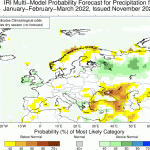
- Long-term seasonal model for precipitation for January/February/March 2022
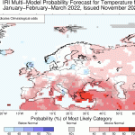
- Long-term seasonal model for temperature for January/February/March 2022
FURTHER OUTLOOK (TEMPERATURE) FOR JAN-FEB-MAR 2021/2022 – Warmer than Average
FURTHER OUTLOOK (PRECIPITATION) FOR JAN-FEB-MAR 2021/2022 – Average*
* An ‘Average’ outlook means that maps are pointing towards normal storm system activity around the central Mediterranean. Whether or not a month ends up being drier or wetter than average will depend on whether any rain-producing systems that form affect land or not. This is because one or two stormy episodes may easily produce plentiful precipitation, pushing values to above average. Conversely, one or two near misses may leave the Maltese Islands land area dry, pushing values to below average.


0 comments
Write a comment