Air Temperature
| Highest Maximum | 22.2°C | 7th |
| Lowest Maximum | 10.2°C | 15th |
| Highest Minimum | 15.1°C | 6th |
| Lowest Minimum | 5.9°C | 16th |
| Mean Maximum | 16.9°C |
| Mean Minimum | 11.4°C |
| Mean | 14.1°C |
Relative Humidity
| Highest Relative Humidity | 94% | 4th |
| Lowest Relative Humidity | 43% | 15th |
| Mean Relative Humidity | 76.6% |
Atmospheric Pressure
| Highest Atmospheric Pressure | 1035.2hPa | 23rd and 24th |
| Lowest Atmospheric Pressure | 1001.0hPa | 7th |
| Mean Atmospheric Pressure | 1021.9hPa |
Wind
| Highest Gust | 78.9km/h | 7th |
| Mean Wind Speed | 9.3km/h |
| Mean Gust Speed | 18.1km/h |
| Mean Wind + Gust Speed | 13.7km/h |
| Most Frequent Wind Direction | Northwest |
Precipitation
| Total Rainfall During February 2021 | 3.4 mm |
| Total Rainfall Since Last 01/09 | 391.7 mm |
| Highest 24 Hour Total | 1.8 mm | 2nd |
| Rain Days | 3 |
| Thunderstorm Days | 0 |
| Hail Days | 0 |
Rainfall Events
| 02/02/2021 | 1.8 mm | Isolated Shower |
| 13/02/2021 | 1.1 mm | Light Rain |
| 14/02/2021 | 0.5 mm | Light Rain |
February 2021 Compared to the Climate Means
| Climate Mean | February 2021 | Anomaly | |
| Mean Maximum Temperature | 15.5°C | 16.9°C | +1.4°C |
| Mean Minimum Temperature | 9.6°C | 11.4°C | +1.8°C |
| Mean Temperature | 12.6°C | 14.1°C | +1.5°C |
| Mean Relative Humidity | 78% | 76.6% | -1.4% |
| Mean Atmospheric Pressure | 1016.6hPa | 1021.9hPa | +5.3hPa |
| Mean Wind Speed | 19.1 km/h | 13.7 km/h | -5.4 km/h |
| Most Frequent Wind Direction | Northwest | Northwest | 0° |
| Total Rainfall | 61.5 mm | 3.4 mm | -58.1 mm |
| Total Rainfall Since Last 01/09 | 473.0 mm | 391.7 mm | -81.3 mm |
| Total Rain Days | 10 days | 3 days | -7 days |
| Total Thunderstorm Days | 3 days | 0 days | -3 days |
| Total Hail Days | 1 day | 0 days | -1 day |
February 2021 among the driest ever
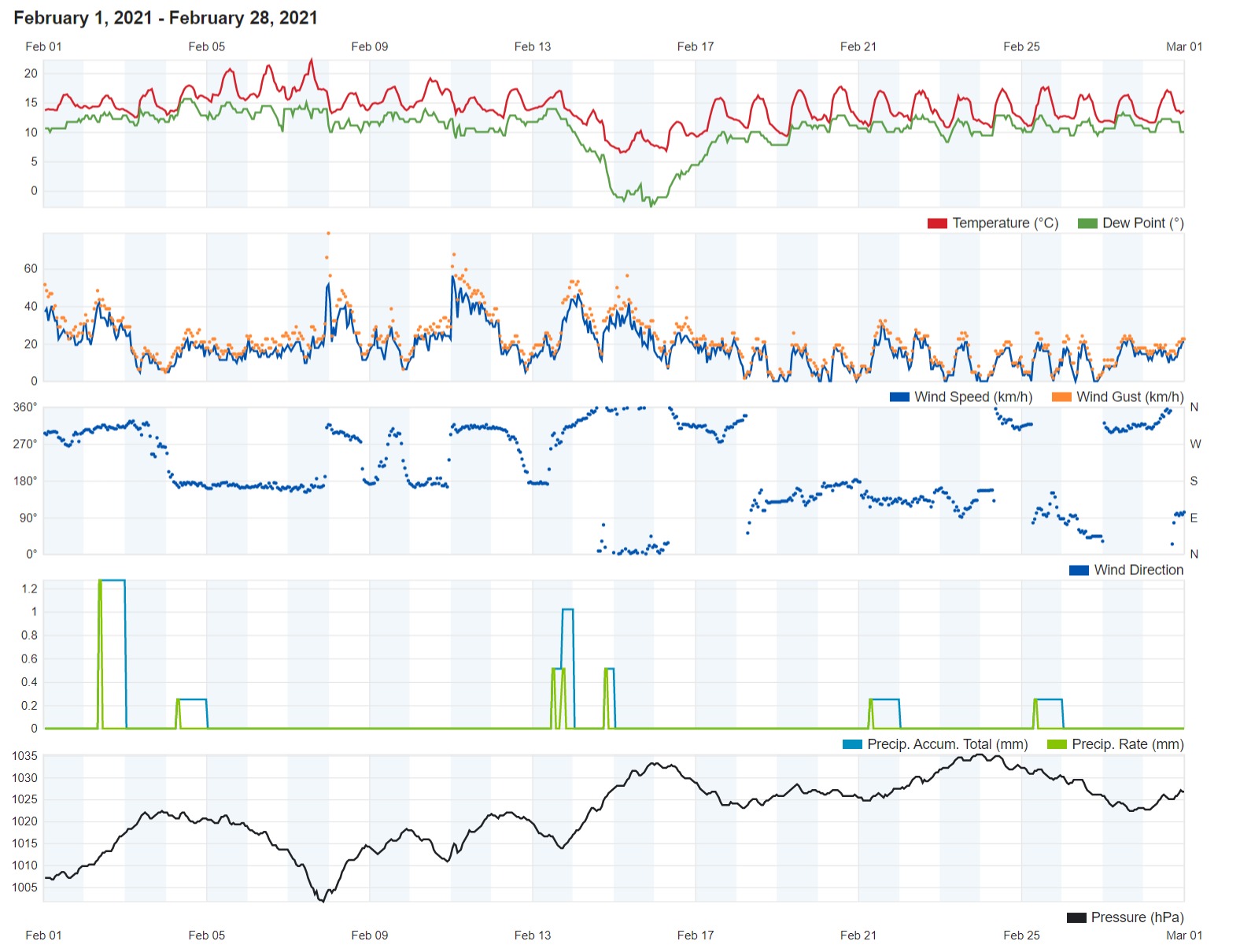
Leave for a few days halfway through the month, February 2021 was a very mild one. Overall, temperatures were a staggering 1.5°C above the climate norm. With a maximum temperature of 10.2°C, the 15th was last month’s coldest day. The air temperature before dawn on the 16th dipped to a cold 5.9°C, making it the coldest night of February 2021. The vast majority of days last month featured comfortable temperatures, with daytime highs in the region of 17°C and nighttime lows of around 11°C being the most common values. The temperature also shot up to above 20°C on three days (the 5th, 6th and 7th).
Rain over the course of February 2021 was very scarce. In fact, it was among the driest ever. Only 3.4 mm were measured in Għarb. That is just 5% of the climate average. This was spread over three days. The rain was light on all three occasions. Although the situation may not have been as dire in other localities around the Maltese Islands, no area of the nation accumulated more than 10 mm of rain over the course of last month.
The mean reading of atmospheric pressure for February 2021 was of 1021.9hPa. This is much higher than the typical value for this time of year. This was due to an anticyclone that formed halfway through the month and remained stationary over the central Mediterranean till its end. This anticyclone saw readings exceeding 1030hPa on a number of days. The first half of the month was less stable.
The wind reached strengths of Force 7 on 5 days, Force 8 on 1 day and Force 9 on 1 day. All seven windy occurred in the less settled first half of the month. The strongest gust recorded was that of 78.9 km/h. This was on the 7th. The second half of last month feature a long and uninterrupted run of light winds. The wind blew from southerly quadrants on an astonishing twelve days.

Rainfall Totals around the Maltese Islands in February 2021 (and since last September 1st)
Għarb – 3.4 mm (391.7 mm)
Victoria – 4.6 mm (399.5 mm)
Xewkija – 2.7 mm (324.0 mm)
Nadur – 2.9 mm (458.8 mm)
Mellieħa – 2.0 mm (263.8 mm)
Buġibba – 3.0 mm (311.6 mm)
Mġarr – 1,8 mm (289.1 mm)
Għargħur – 1.3 mm (390.3 mm)
Attard – 3.6 mm (463.3 mm)
Rabat – 3.7 mm (303.6 mm)
Msida – 8.4 mm (416.9 mm)
Valletta – 0.0 mm (253.6 mm)
Luqa – 9.1 mm (414.5 mm)
Żabbar – 9.2 mm (440.2 mm)
Birżebbuġa – 4.1 mm (302.4 mm)


0 comments
Write a comment