
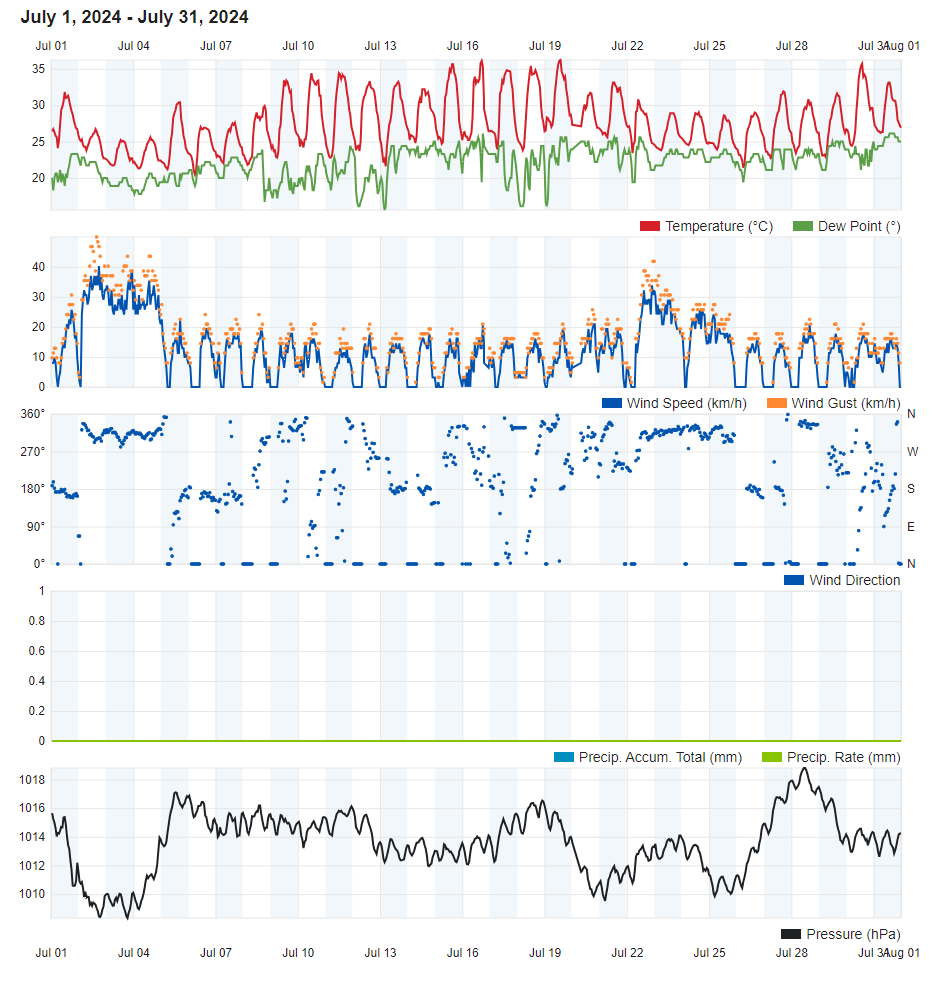
Air Temperature
| Highest Maximum | 36.2°C | 19th |
| Lowest Maximum | 25.2°C | 3rd |
| Highest Minimum | 26.3°C | 20th |
| Lowest Minimum | 19.6°C | 6th |
| Mean Maximum | 31.5°C |
| Mean Minimum | 22.8°C |
| Mean | 27.2°C |
Relative Humidity
| Highest Relative Humidity | 93% | Numerous days |
| Lowest Relative Humidity | 29% | 16th |
| Mean Relative Humidity | 73.7% |
Wind
| Highest Gust | 49.9km/h | 2nd |
| Mean Wind Speed | 9.1km/h |
| Most Frequent Wind Direction | Northwest |
Atmospheric Pressure
| Highest Atmospheric Pressure | 1018.8hPa | 28th |
| Lowest Atmospheric Pressure | 1007.0hPa | 2nd |
| Mean Atmospheric Pressure | 1013.3hPa |
Precipitation
| Total Rainfall During July 2024 | 0.0 mm |
| Total Rainfall Since Last 01/09 | 272.7 mm |
| Highest 24 Hour Total | / | / |
| Rain Days | 0 days |
| Thunderstorm Days | 0 days |
| Hail Days | 0 days |
Rainfall Events
| 08/07/2024 | Mist | |
| 14/07/2024 | Fog | |
| 29/07/2024 | Mist |
July 2024 Compared to the Climate Means
| Climate Mean | July 2024 | Anomaly | |
| Mean Maximum Temperature | 31.6°C | 31.5°C | -0.1°C |
| Mean Minimum Temperature | 22.5°C | 22.8°C | +0.3°C |
| Mean Temperature | 27.0°C | 27.2°C | +0.2°C |
| Mean Relative Humidity | 70.2% | 73.7% | +3.5% |
| Mean Atmospheric Pressure | 1014.6hPa | 1013.3hPa | -1.3hPa |
| Total Rainfall | 0.2 mm | 0.0 mm | -0.2 mm |
| Total Rainfall Since Last 01/09 | 518.8 mm | 272.7 mm | -246.1 mm |
| Total Rain Days | 0 days | 0 days | / |
| Total Thunderstorm Days | 0 days | 0 days | / |
| Total Hail Days | 0 days | 0 days | / |
Typical Summer Weather in JULY 2024
With a mean air temperature of 22.8°C, July was marginally warmer than average. This value by itself doesn’t reveal much. A heat spell with sweltering temperatures from the 9th through to the 22nd was countered by a cooler than average first week of the month. This was brought about by cooler air from the north thanks to an episode of strong Northwesterly winds. This episode accounted for the month’s highest wind gust of 49.9km/h on the 2nd. The final nine days of the month contained a fair mix of days with temperatures above and below the norm. Once again this was the result of fresh, albeit less strong, Northwesterly winds. The maximum temperature peaked at 36.2°C on the 19th. The fourteen-day heat spell comprised a mean maximum temperature of 34.1°C at our weather station in Għarb. Values were higher across Malta. Mean minimum temperatures experienced a gradual rise. This corresponded with a more rapid rise in mean sea surface temperature. The mean sea surface temperature around the Maltese Islands stood at 29°C. That is some 2°C warmer than average. A very warm sea inhibits nighttime cooling of the air. Values of relative humidity were higher than the norm. This made the air feel rather clammy and uncomfortable at times.
July 2024 also lived up to its expectation of being a completely dry month. No rain made it to the Maltese Islands throughout. Some mist or fog patches were observed.
Rainfall Totals around the Maltese Islands in July 2024 (and since last September 1st):
Għarb: 0.0 mm (269.4 mm)
Victoria: 0.0 mm (291.6 mm)
Xewkija: 0.0 mm (184.1 mm)
Nadur: 0.0 mm (277.6 mm)
Marsalforn: 0.0 mm (213.3 mm)
Mellieħa: 0.0 mm (226.1 mm)
Buġibba: 0.0 mm (279.9 mm)
Mġarr: 0.0 mm (259.5 mm)
Naxxar: 0.0 mm (284.7 mm)
Mosta: 0.0 mm (278.8 mm)
Dingli: 0.0 mm (267.3 mm)
Msida: 0.0 mm (279.8 mm)
Valletta: 0.0 mm (217.6 mm)
Imqabba: 0.0 mm (270.3 mm)
Birżebbuġa: 0.0 mm (235.2 mm)
Sliema: 0.0 mm (253.5 mm)
Fgura: 0.0 mm (242.2 mm)
NATIONAL MEAN: 0.0 mm (254.8 mm)